Teachers guide students to use Exploring Society India and Beyond Class 8 Solutions and Class 8 Social Science SST Part 2 Chapter 1 World Geography Some Glimpses Question Answer NCERT Solutions for quick learning.
World Geography Some Glimpses Class 8 Questions and Answers
World Geography Some Glimpses Class 8 Question Answer
The Big Questions (NCERT Page No. 1)
Question 1.
What are the unique physical features of the continents?
Answer:
The unique physical features of continents are as follows
- Continents have high mountain ranges with steep slopes and narrow summits that influence climate, store water in the form of snow, and are rich in minerals and forests.
- They have plateaus which are raised flat lands formed by tectonic forces and are important sources of minerals and major rivers.
- Continents include vast plains formed by river deposition, having fertile soil that supports agriculture, trade, and dense population.
- They also have deserts and grasslands with very little rainfall or seasonal rainfall, supporting specially adapted
plants, animals, and nomadic communities.
Question 2.
Why do we need to understand world geography?
Answer:
We need to understand world geography because of the following reasons
- It helps us know about different landforms and water bodies such as mountains, plains, deserts, rivers, and
oceans, and how they are formed by natural processes. - It explains how these physical features influence climate, ecosystems, agriculture, settlement, and trade in different parts of the world.
- It makes us aware of environmental problems like deforestation, pollution, desertification, biodiversity loss,
and climate change caused by human activities. - It helps us understand the importance of managing natural resources wisely for sustainable development and
protecting the balance of nature.

Question 3.
How do human actions trigger environmental Issues?
Answer:
Human actions trigger environmental issues in the following ways
- Deforestation destroys forests and wildlife habitats, leading to loss of biodiversity and disturbing the natural
balance of ecosystems. - Overuse of natural resources such as minerals, water, and fossil fuels reduces their availability and damages
land and water bodies. - Pollution of air, water, and soil from industries, vehicles, and waste harms living beings and affects climate and
health. - Rapid industrialisation and burning of fuels increase greenhouse gases. causing global warming, melting of
ice, rising sea levels, and climate change, which disturb weather patterns and natural systems.
Class 8 World Geography Some Glimpses Question Answer
Let’s Explore (NCERT Page No.11)
Question 1.
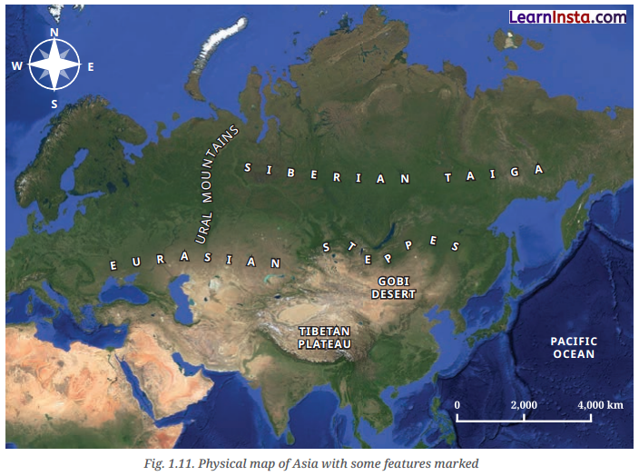
Study the map given below. What are the different physical features represented here?
Answer:
The different physical features represented on the physical map of Asia are as follows
- The map shows high mountain ranges in dark brown colour, such as the Himalayas, which are very high and influence climate and rivers.
- It shows plateaus in yellow or brown colour, like the
- Tibetan Plateau, which is the highest and largest plateau in the world.
- Plains are shown in green colour. These are flat and fertile areas that support agriculture and dense population.
- Deserts and water bodies are also shown. Deserts like the Gobi are marked in light yellow, and oceans, seas, and rivers are shown in blue colour.
Let’s Explore (NCERT Page No. 18)
Question 2.
Observe the area covered by the European Plain. Now turn to the political map of the world at the end of this
textbook. List the countries that are part of the European Plain.
Answer:
The countries that are part of the European Plain include France, Belgium, Netherlands, Germnay, Poland,Denmark, Belarus, Ukraine and Russia. The European Plain stretches across these countries and forms one of the largest flat and fertile regions in the world.
Let’s Explore (NCERT Page No. 22)
Question 3.
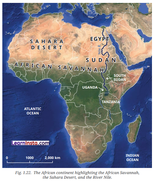
On the map given below locate the course of the River Nile. Where does ¡t originate from and in which direction does it flow? Turn to the political map at the end of the book, and identify some of the areas that the river flows through.
Answer:
- The River Nile originates from the region around Lake Victoria in East Africa.
- It flows in a Northward direction, which is unusual as most rivers flow South.
- The river passes through countries such as South Sudan, Sudan, and Egypt. Finally, it drains into the Mediterranean Sea. The Nile and its basin have supported agriculture and settlements for thousands of years,
especially in Egypt, where it helped in the development of ancient civilisation.
Let’s Explore (NCERT Page No. 24)
Question 4.
The Amazon Rainforest has been called the Lungs of the Earth, Why do you think this might be so?
Answer:
The Amazon Raintorest has been called the ‘Lungs of the Earth’ because of the following reasons
- It has a vast number of trees and plants that absorb carbon dioxide and release oxygen through photosynthesis
- It helps in maintaining the balance of gases in the atmosphere, which is essential for life on Earth.
- It supports rich biodiversity and plays an important role in regulating the global climate and rainfall patterns.
- It helps reduce the effects of climate change and protects the planet’s environment.
Question 5.
The countries in this region need land for development but risk losing the Amazon Rainforest. Discuss In groups: What are the short and long-term effects of deforestation, and how can we protect the Amazon for the planet?
Answer:
The short and long-term effects of deforestation are
| Short-term Effects | Long-term Effects |
| Ravi chooses not to join a protest march because he disagrees with it. | Increase in carbon dioxide levels leading to climate change. |
| Soil becomes exposed, leading to quick loss of fertility and risk of floods. | Disturbance in rainfall patterns causing droughts and long-term environmental imbalance. |
Ways to Protect Amazon
We can protect the Amazon for the planet through the following ways
- By controlling deforestation and enforcing strict laws against illegal cutting of trees.
- By promoting sustainable development, where land and forest resources are used carefully without destroying
nature. - By supporting indigenous communities and conservation efforts to preserve the rainforest and its rich biodiversity.
Class 8 SST Part 2 Chapter 1 Question Answer
Question and Activities (NCERT Page No. 31-32)
Question 1.
Why do all map projections have some amount of distortion?
Answer:
All map projections have some amount of distortion because of the following reasons
- The Earth is an oblate spheroid, and its curved surface cannot be shown perfectly on a flat sheet of paper.
- Flattening a curved surface always causes stretching or shrinking of some areas.
When the globe is projected onto a flat surface, the shapes of continents and countries, especially near the
poles, become distorted. - Some projections preserve shape and direction but distort size, while others show correct size but change shape. It is not possible to show all features accurately at once.
- Distance and direction between places also change in many projections, leading to further distortion on world maps.
Question 2.
What makes the Tibetan Plateau unique?
Answer:
The Tibetan Plateau is unique because of the following reasons
- It was formed due to the collision of the Indo-Australian and Eurasian tectonic plates, which also resulted in the formation of the Himalayan mountain range.
- The plateau stretches about 2500 km from East to West and about 1,000 km from north to south, making it a vast elevated region.
- It plays a very important role in influencing the climate of Asia and is the source of major rivers such as the
Indus, Brahmaputra, and Yangtze. - It contains the largest reserves of freshwater outside the polar regions and is often called the ‘Third Pole’
because of its snow and ice.
Question 3.
Why are coral reefs called the rainforests of the sea?
Answer:
Coral reefs are called the rainforests of the sea because of the following reasons
- They provide food and shelter to about one-quarter of all ocean species, including fish, crabs, turtles, and
sponges. - They form complex and interconnected habitats built by tiny sea animals called corals, supporting many kinds of marine life.
- Like rainforests on land, they support a very large number of species living together in a small area.
- They help maintain the balance of marine ecosystems, but are seriously threatened by overfishing, pollution, and climate change.
Question 4.
How do the oceans help to regulate the Earth’s climate?
Answer:
The oceans help to regulate the Earth’s climate in the following ways
- Oceans absorb a large amount of heat from the Sun and store it, preventing the Earth from becoming too hot.
- They slowly release the stored heat into the atmosphere, which helps maintain balanced temperatures across the planet.
- Oceans add moisture to the air through evaporation, leading to the formation of clouds and rainfall that influence weather patterns.
- Ocean currents, both warm and cold, move heat from the equator toward the poles and from the poles toward the equator, helping to control global climate and temperature distribution.
Question 5.
What is the main reason for the Great Barrier Reef facing threats today?
Answer:
The main reasons for the Great Barrier Reef facing threats today are as follows
- Overfishing disturbs the balance of marine life and reduces the number of species that depend on the reef for
food and shelter. - Pollution from human activities changes the chemical composition of ocean waters harming corals and other
sea organisms. - Climate change increases ocean temperatures, leading to coral bleaching and death of corals.
- Human actions such as careless tourism and coastal activities damage the reef structure, making conservation
efforts necessary to protect this important ecosystem.
Question 6.
Why is the Amazon Rainforest often called the ‘Lungs of the Earth’?
Answer:
The Amazon Rainforest has been called the ‘Lungs of the Earth’ because of the following reasons
- It has a vast number of trees and plants that absorb carbon dioxide and release oxygen through photosynthesis.
- It helps in maintaining the balance of gases in the atmosphere, which is essential for life on Earth.
- It supports rich biodiversity and plays an important role in regulating the global climate and rainfall patterns.
- It helps reduce the effects of climate change and protects the planet’s environment.
Question 7.
Choose two different types of geographical features you have explored in this chapter. Write short paragraphs on how they influence the flora and fauna or human lives in that area. Do they also have an Implication for the whole globe?
Answer:
I have chosen the Sahara Desert and the Amazon Rainforest as two geographical features explored in this chapter. Their infLuence on the flora and fauna or human lives and implications on the whole globe are as follows: The Sahara Desert. The Sahara Desert influences the flora, fauna, and human life in that area because its hot and dry climate allows only specially adapted plants and animals to survive. People live a nomadic life and depend on oases and livestock. It also has a global impact as dust from the Sahara reaches the Amazon and supports plant growth there.
The Amazon Rainforest: The Amazon Rainforest influences the flora, fauna, and human life in that area because its warm climate and heavy rainfall support dense forests and rich biodiversity. Thousands of plant and animal species live there, many of which are unique to the region. Indigenous communities depend on the forest for food and shelter. It also has a global impact because it absorbs carbon dioxide, regulates climate, and influences rainfall patterns across the world.
Question 8.
Discuss how oceans influence climate and trade. Use examples from the Indian and Pacific Oceans.
Answer:
Oceans influence climate and trade in the following ways
Influence on Climate
- Oceans absorb and store heat from the Sun and slowly release it, helping to regulate climate. The Indian Ocean influences the monsoon in the Gangetic Plains, affecting rainfall and agriculture.
- Ocean currents distribute heat across the globe. The Pacific Ocean, being the largest and deepest, plays an important rote in controlling global temperature patterns.
Influence on Trade
- Oceans serve as major water highways for trade and transport. The Indian Ocean has historically been important for international trade between Asia, Africa, and Europe.
- The Pacific Ocean supports busy shipping routes and rich fishing grounds. making it vital for global trade and
economic activities.
Question 9.
Choose one environmental issue (deforestation, reef bleaching, or desertification) and explain its causes,
Impacts, and possible solutions.
Answer:
Deforestation is an environmental issue in which a large number of forests are cleared by human activitIes. The
causes, impacts, and possible solutions of the deformatior are as follows
Causes
- Forests are cleared for farming, roads, industries, and settlements.
- Trees are cut for resources and development, especially in regions like the Amazon Rainforest.
Impacts
- It destroys wildlife habitats and reduces biodiversity.
- It increases carbon dioxide in the atmosphere, leading t climate change and disturbed rainfall patterns.
Possible Solutions
- Enforce strict laws to control illegal cutting of trees.
- Promote sustainable development and support conservation of forests and indigenous communities.
Question 10.
Imagine you are a geographer asked to advise a government about protecting one major landscape in your country. Which one would you choose, and why?
Answer:
If I were a geographer, I would choose to protect the Himalayan mountain range in my country. The Himalayas are very important because they influence the climate and help in bringing rainfall through the monsoon system. They are also the source of major rivers that provide water for drinking, irrigation, and electricity.
The mountains support rich biodiversity, forests, and wildlife. Many people depend on them for farming, tourism, and livelihood. However, deforestation, pollution, and climate change are causing glacier melting and environmental damage. Protecting the Himalayas is necessary to maintain ecological balance, ensure water security, and prevent natural disasters like floods and landslides in the future.
Question 11.
Imagine that someone ¡s funding a group of you for a road trip across two continents. There are differences of opinion on which two they should be. Make a pitch for the ones you would like everyone to go to. Use a blank map, trace your route and locate the places on it, and try to convince the others to your point of view. You could use a variety of creative ways.
Answer:
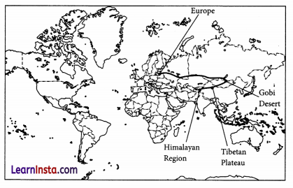
If I had to choose two continents for our road trip, I would choose Asia and Europe. We would begin our journey in Asia from the Himalayan region, cross the Tibetan Plateau, and travel towards the Gobi Desert. From there, we would move westwards and cross the Ural Mountains, which form a natural boundary between Asia and Europe. Entering Europe. we would travel across the vast European Plain and finally reach the beautiful Alps.
This route would allow us to see high mountains, plateaus, deserts, plains, and river valleys-all in one trip. We would experience different climates, cultures, wildlife, and landscapes. Asia and Europe together offer the greatest variety of physical features, making our road trip educational, adventurous, and unforgettable.