Students revise important topics using Class 8 Social Science Extra Questions and Class 8 SST Part 2 Chapter 1 World Geography Some Glimpses Important Extra Question Answer before exams.
World Geography Some Glimpses Class 8 Extra Question Answer
Extra Questions of World Geography Some Glimpses Class 8
World Geography Some Glimpses Class 8 Very Short Question Answer
Question 1.
Why is the Earth called the ‘Blue Planet ‘?
Answer:
The Earth is called the “Blue Planet” because about 71% of its surface is covered by oceans, giving it a blue appearance from space, and oceans regulate climate and support life.
Question 2.
Write the main advantage of the Robinson Projection?
Answer:
The main advantage of the Robinson Projection is as follows
- Provides a visually balanced view of the world by reducing the overall distortion of continents and oceans, making world maps easier to read and interpret.
- Maintains a reasonable balance of size and shape, so no single area appears excessively stretched or compressed compared to many other world map projections.
Question 3.
How do oceans help in climate regulation?
Answer:
Oceans help in climate regulation by absorbing heat from the Sun, releasing it slowly, and adding moisture to the air, which stabilizes temperatures and influences rainfall and weather patterns globally.

Question 4.
Which ocean surrounds Antarctica, and what is one of its important features?
Answer:
- The ocean that surrounds Antarctica is the Southern Ocean, which encircles the continent and is home to penguins, seals, and other cold-climate marine life.
- The important feature of this ocean is its very cold waters, strong currents, and rich marine life.
Question 5.
Reefs called the ‘rainforests of the sea’. Why?
Answer:
Reefs are called the “rainforests of the sea” because they provide food, shelter, and habitat for about one-quarter
of all ocean species, supporting rich biodiversity similar to rainforests on land.
Question 6.
Why is the Persian Gulf historically important?
Answer:
The Persian Gulf is historically important because it has been a major trade route for thousands of years, connecting India, the Middle East, and Europe, and facilitating the exchange of goods, culture, and ideas.
Question 7.
What is a plateau and how does they form?
Answer:
A plateau is an elevated, flat landform that rises sharply above the surrounding area, often with steep sides, and is suitable for farming, mining, and human settlements.
Plateaus are formed by geological processes like volcanic activity or erosion and are often rich in minerals.
Question 8.
Mention two rivers originating from the Tibetan Plateau.
Answer:
Two rivers originating from the Tibetan Plateau are the Indus and the Brahmaputra, both of which provide water for millions of people and support agriculture and ecosystems in Asia.
Question 9.
Which is the highest peak in the Andes Mountains, and what is its important feature?
Answer:
Aconcagua is the highest peak in the Andes Mountains. The important feature of this peak is that it is the tallest
mountain in South America, reaching 6,961 meters. It attracts climbers from around the world and has snow-covered slopes throughout the year.
World Geography Some Glimpses Class 8 Short Question Answer
Question 1.
What is meant by the term ‘oblate spheroid ‘ in relation to Earth?
Answer:
In relation to the Earth, the term “oblate spheroid” means that the Earth is slightly flattened at the poles and
bulging at the equator. This shape is caused by the Earth’s rotation, which pushes mass outward along the
equator.
As a result, the equatorial diameter is slightly larger than the polar diameter. Understanding Earth as an oblate spheroid helps in accurate mapping, navigation, and studying phenomena like gravity, tides, and climate patterns, showing that Earth is not a perfect sphere.
Question 2.
How do deep-sea trenches support unique life forms?
Answer:
Deep-sea trenches support unique life forms in the following ways
- They provide chemical-rich water, allowing organisms like chemosynthetic bacteria to produce energy without
sunlight. - The extreme pressure, cold, and darkness create specialized conditions where only adapted species can survive.
- Trenches supply nutrient flows from surrounding waters and sediments, sustaining food chains for deep-sea animals like tube worms, crustaceans, and unusual fish.
Question 3.
Describe the main features of mountains.
Answer:
The main features of mountains are as follows
- Mountains have high elevation with broad bases, steep slopes, and narrow peaks. giving them a rugged and elevated structure.
- They influence climate and weather patterns by blocking winds and causing rainfall. It also creates rain shadows in some areas.
- They provide rivers, forests, and mineral resources, supporting human life through agriculture, grazing, mining, and tourism, and also offer habitats for diverse wildlife.
Question 4.
How are plateaus suitable for farming and human settlements?
Answer:
Plateaus are suitable for farming and human settlements in the following ways
- The flat and elevated terrain of plateaus makes it easier to cultivate crops, build homes, and develop villages and towns.
- Many plateaus have fertile soils and water sources from rivers and lakes, which support agriculture, drinking water, and daily human needs.
- Open grazing areas and natural elevation offer space for livestock and protection from floods, enabling sustainable livelihoods and settlements.
Question 5.
How do plains contribute to agriculture and human settlements?
Answer:
Plains contribute to agriculture and human settlements in the following ways
- Fertile soils and flat terrain make plains ideal for cultivating crops such as wheat, rice, and vegetables, supporting food production.
- Rivers flowing through plains provide water for irrigation, drinking, and other daily needs, sustaining
agriculture and human life. - The gentle landscape allows easy construction of homes, roads, and towns, supports grazing for livestock, and
facilitates trade and transportation, making plains highly suitable for dense human settlements and economic activities.
Question 6.
The European Plain is one of the largest plains in the world. Evaluate the main features of European Plain?
Answer:
The main features of the European Plain are as follows
- The European Plain is a vast low-lying flatland that stretches across much of northern and central Europe, featuring gentle rolling hills and minimal elevation changes.
- It has wide river valleys, including major rivers like the Rhine, Danube, and Elbe, which provide natural drainage, fertile soil, and support ecosystems across the region.
- The plain contains rich soils, mineral deposits like coal, oil, and natural gas. and a generally mild climate, making it an important geographical and economic region in Europe.
Question 7.
The Amazon River is the longest river in South America. Evaluate how it supports both human life and the surrounding ecosystem.
Answer:
The Amazon River supports human life and surrounding ecosystem through the following ways
- It provides water for drinking, irrigation, and daily human activities, supporting agriculture and settlements along its banks.
- Its basin sustains the Amazon Rainforest, which is home to diverse wildlife, plants, and almost 400 indigenous
communities, maintaining ecological balance. - The river enables fishing and transportation, while its nutrient-rich waters sustain aquatic life and fertile lands for crops.
Question 8.
Why ¡s the Atacama Desert Ideal for scientific research?
Answer:
The Atacama Desert is ideal for scientific research due to the following reasons,
- Its extreme dryness and minimal rainfall create conditions similar to Mars, allowing testing of space instruments and rovers.
- The rocky and barren terrain provides a stable surface for geological studies and experiments without interference from vegetation.
- Clear skies with very low light pollution make it perfect for astronomical observations and climate research, helping scientists study stars, planets, and atmospheric conditions effectively.
World Geography Some Glimpses Class 8 Long Question Answer
Question 1.
Explain the importance of studying world geography and its relation to human life.
Answer:
The importance of studying world geography and its relation to human life can be explained as follows
- It helps us understand Earth’s landforms, oceans, rivers, mountains, and deserts, which influence climate, vegetation, wildlife, and human activities.
- Knowledge of geography aids in managing natural resources like water, minerals, and soil efficiently, promoting sustainable development.
- It enables prediction and preparedness for natural disasters such as floods, earthquakes, and cyclones, reducing human and economic losses.
- Geography explains how people interact with their environment, shaping settlements, trade, culture, and lifestyles across regions.
- It provides a global perspective by clearly showing the interconnections between trade, migration, and climate systems, helping planners and policymakers understand and address environmental and global challenges more effectively.
Question 2.
Describe the challenges involved in representing the curved Earth on flat maps.
Answer:
The challenges involved in representing the curved Earth on flat maps are as follows
- The Earth’s three-dimensional, slightly flattened shape makes it difficult to accurately depict on a two-dimensional surface.
- Accurately representing the area of landmasses is challenging, since flattening the Earth’s curved surface causes some regions, especially polar areas, to appear larger or smaller than their actual size.
- Maintaining correct shapes is difficult, as flattening can stretch or compress continents, making them look distorted compared to reality.
- Showing correct distances between places is difficult, since a flat map cannot perfectly represent the Earth’s curved surface, affecting navigation and route planning. Representing natural features such as mountains, valleys, and ocean depths proportionally is hard, as flattening changes their relative positions and appearance.
Question 3.
Compare and contrast the Mercator and Robinson projections.
Answer:
The Mercator and Robinson projections can be compared as follows
| Feature | Mercator Projection | Robinson Projection |
| Purpose | It is mainly used for Navigation because it shows directions correctly. | It is mainly used for world Maps because it gives a more natural and balanced view of the Earth. |
| Shape | It shows the shapes of Countries correctly, especially near the Equator. | It shows the shapes of Countries fairly well, but there is a small amount of distortion. |
| Size/Area | It greatly changes the Size of land areas near the poles. For example, Greenland appears much larger than it really is. | It shows the sizes of Continents more accurately, with less distortion than the Mercator projection. |
| Polar Regions | Polar regions appear much larger than they actually are. | Polar regions are slightly compressed to make the Whole world map look more Balanced. |
| Usefulness | It is best for sea and air navigation because directions can be followed correctly. | It is best for school Maps, atlases, and general Study because it gives a more realistic picture of the world. |
Question 4.
Oceans play a vital role in supporting life on Earth and regulating climate. Discuss how oceans impact both life and climate.
Answer:
The importance of oceans for life and climate can be understand by the following points
- Oceans provide habitats for a wide variety of marine organisms, from microscopic plankton to large mammals like whales, supporting biodiversity.
- Plankton in the oceans produce nearly half of the world’s oxygen, which is essential for all living beings.
Oceans absorb solar heat and release it slowly, helping regulate global temperatures and maintain stable climate conditions. - Ocean currents distribute heat and nutrients across the world, influencing regional climates, rainfall patterns, and supporting marine food chains.
- Oceans store carbon dioxide and other gases, playing a crucial role in controlling greenhouse gases and maintaining ecological balance, which affects both human life and natural ecosystems.
Question 5.
Explain the major landforms of the Earth and their influence on human life.
Answer:
The major landforms of the Earth are Mountains, Plateaus, plains, and Deserts. Their influence on human life can be explained as follows
- Mountains are high-elevation lands with steep slopes and narrow peaks. They provide rivers, forests, minerals, grazing land, and tourism opportunities but limit settlements and farming.
- Plateaus are elevated flat lands, often with steep sides and broad surfaces. They support agriculture due to fertile soils, provide minerals, grazing areas, and protection from floods.
- Plains are wide, flat, or gently rolling Lands with minimal elevation changes. They are ideal for agriculture, settlements, trade, and transportation because of flat terrain and fertile soils.
- Deserts are large, dry areas that receive very little rainfall and support unique plants and animals adapted to extreme conditions. They have sparse vegetation and extreme climates, influencing human migration, trade routes, and settlement patterns.
Question 6.
Discuss the role of ocean currents in regulating coastal and global climates.
Answer:
The role of ocean currents in regulating coastal and global climates is as follows
- Ocean currents carry warm water from the equator toward the poles and from the poles toward the equator, helping balance global temperatures.
- Warm currents raise temperatures of nearby coastal regions, making climates milder and more suitable for human settlement and agriculture.
- Cold currents lower coastal temperatures, often creating cooler and drier climatic conditions along western continental margins.
- Currents influence rainfall patterns by affecting evaporation and moisture in the air, thereby shaping monsoon systems and regional weather conditions.
- Ocean currents moderate extreme temperatures by preventing coastal and global regions from becoming excessively hot or cold, helping maintain climate stability.
Question 7.
Smaller water bodies and waterways play an important role in local ecosystems and human life. Evaluate their types and explain how they are important in ecosystems.
Answer:
The smaller water bodies and waterways are of following types
- Seas are large bodies of salt water that are partly surrounded by land and connected to an ocean.
- Gulfs are large parts of the sea that extend into the land.
- Bays are broad parts of the sea that extend into the land.
- They are usually smaller than gulfs.
- Straits are narrow water passages that connect two seas or oceans.
- Canals are man-made waterways built to connect two water bodies or to help in transport and irrigation.
The importance of smaller water bodies and waterways in the ecosystem are as follows
- They function as major maritime routes connecting countries and continents, enabling the movement of goods. raw materials, and passengers, which promotes international trade and economic development.
- They provide rich fishing grounds. support diverse marine biodiversity and sustain the livelihoods of coastal communities through fishing, tourism, and related activities.
- Canals and straits enhance global connectivity by providing direct sea links between important water bodies, improving access to markets and increasing the overall efficiency of international trade systems.
Question 8.
The Tibetan Plateau plays a significant role in Asia’s climate and river systems. Explain the importance of the Tibetan Plateau.
Answer:
The importance of the Tibetan Plateau is as follows
- It is known as the ‘Third Pole’ because it holds the largest reserves of freshwater outside the polar regions,
supplying water to major rivers. - Major rivers such as the Indus, Brahmaputra, and Yangtze originate from this plateau, supporting millions of people for drinking, irrigation, and agriculture.
- It plays a crucial role in shaping Asia’s climate by influencing monsoon patterns and atmospheric circulation.
- Its glaciers and snowfields act as natural water storage systems, releasing water gradually and sustaining river
flow throughout the year. - The plateau’s unique high-altitude ecosystem supports distinct plant and animal species and holds geographical importance due to its vast size and elevation.
Question 9.
Explain the ecological significance of the Amazon Rainforest.
Answer:
The ecological significance of the Amazon Rainforest is as follows
- It acts as the “Lungs of the Earth” by contributing significantly to oxygen production and absorbing large amounts of carbon dioxide, helping regulate the global climate.
- It supports extraordinary biodiversity, providing habitat for countless species of plants, animals, insects, and microorganisms, many of which are not found anywhere else.
- The rainforest plays a crucial role in the water cycle by releasing moisture into the atmosphere through transpiration, influencing rainfall patterns locally and globally.
- It helps maintain soil fertility and prevents erosion by protecting the land with dense vegetation cover.
- It regulates regional and global temperatures by storing carbon and maintaining ecological balance, while also supporting nearly 400 indigenous communities who depend on its resources sustainably.
Question 10.
How have Indigenous communities adapted to life in the Great Australian Desert?
Answer:
Indigenous communities have adapted to life in the Great Australian Desert in the following ways
- They have developed deep knowledge of the desert environment, identifying water sources, seasonal changes, and edible plants to survive in harsh, dry conditions.
- They practice sustainable hunting and gathering, using traditional methods to obtain food such as small animals, reptiles, seeds, and roots without harming the ecosystem.
- Their shelters, clothing, and tools are designed to suit extreme heat and limited resources, using locally available materials.
- They follow seasonal movement patterns, shifting Locations to access food and water while preventing overuse of resources.
- They maintain strong cultural and spiritual connections to the land, passing down knowledge, traditions, and survival skills through generations, ensuring resilience and harmony with the desert environment.
World Geography Some Glimpses Class 8 Case Based Questions
Question 1.
Read the passage given below and answer the following questions.
The Tibetan Plateau is the highest and largest plateau on Earth. Located north of the Himalayan Range, it is the result of collisions between the Indo-Australian and Eurasian tectonic plates, which also led to the formation of the Himalayan mountain range. The plateau stretches about 2,500 km from East to West and 1,000 km from North to South, with an average height of over 4,500 metres above sea level. The region plays an important role in influencing the climate of Asia and is the source of many major rivers, including the Indus, Brahmaputra, and Yangtze.
(i) Which geological process led to the formation of the Tibetan Plateau?
Answer:
The Tibetan Plateau was formed due to the collision of the Indian Plate and the Eurasian Plate. This collision pushed the Earth’s crust upward, forming the Tibetan Plateau and the Himalayas.
(ii) What are the approximate physical dimensions of this plateau?
Answer:
The plateau stretches about 2,500 km from east to west and 1,000 km from north to south.
(iii) Mention any two major rivers that have their source in this region.
Answer:
Two major rivers originating from the plateau are the Indus and the Brahmaputra (the Yangtze is also mentioned).
Question 2.
Read the passage given below and answer the following questions.
The Andes are a vital source of freshwater for millions of people, feeding major rivers including the Amazon, the world’s largest river by volume. Rich in biodiversity, the mountains are also home to thousands of species of mammals, birds, amphibians, reptiles, and fish, many of which are unique to the region. However, only about one-fourth of the original flora and fauna remains, making the Andes a critical conservation hotspot.
(i) Which major river system receives its water supply from the Andes?
Answer:
The Amazon River, which is the world’s largest river by volume, is fed by the freshwater from the Andes.
(ii) What makes the biodiversity of the Andes unique?
Answer:
The Andes are home to thousands of species of animals, many of which are unique to the region and cannot be found
anywhere else.
(iii) Why are the Andes Mountains classified as a ‘conservation hotspot’?
Answer:
They are considered a conservation hotspot because only about one-fourth of the original plants and animals remain,
indicating a significant loss of biodiversity.
World Geography Some Glimpses Class 8 Picture Based Questions
Question 1.
Answer the questions based on the picture given below.
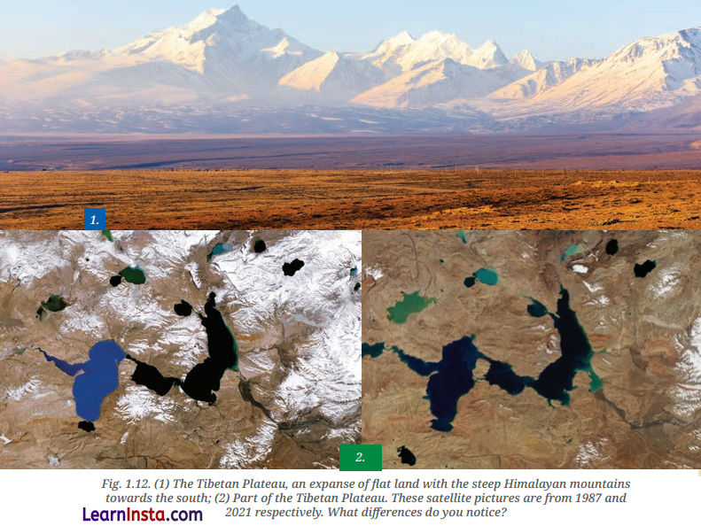
(i) Which unique geographical feature of Asia is represented in this Image?
Answer:
The image represents the Tibetan Plateau, which is the highest and largest plateau on Earth.
(ii) Why is this region often referred to as the ‘Third Pole’?
Answer:
It is called the ‘Third Pole’ because it holds the largest freshwater reserves in the world outside of the North
and South polar regions.
(iii) Which major rivers originate from the landform shown in this picture?
Answer:
Major rivers such as the Indus, Brahmaputra, and Yangtze originate from this plateau.
Question 2.
Answer the questions based on the picture given below.
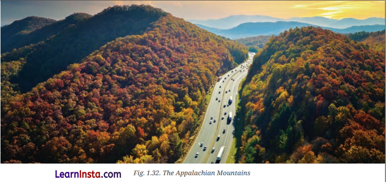
(i) How does the terrain shown ¡n the ¡mage support economic development’
Answer:
The region supports economic growth through the extraction of resources like coal, timber, and natural gas, as well as through growing sectors like tourism.
(ii) What natural advantage did these mountains provide historically for human movement?
Answer:
The Appalachian Mountains provided natural travel routes and fertile valleys that were significant for early settlements.
(iii) What kind of vegetation is typically found in North American mountain ranges like the one pictured?
Answer:
These regions are home to diverse plant life, including coniferous trees (like pine and spruce) and deciduous trees (like oak and maple).
World Geography Some Glimpses Class 8 Map Based Questions
Question 1.
Locate the following on the physical map of world.
(a) The Tibetan Plateau
(b) The Sahara Desert
(c) The Great Barrier Reef
(d) The Andes Mountains
Answer:
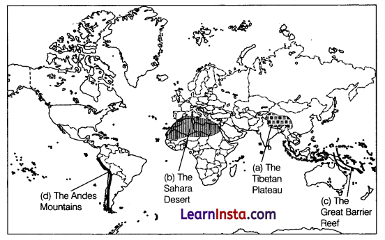
Question 2.
Locate the following on the physical map of world.
(a) The Suez Canal
(b) The Bay of Bengal
(c) The Australian Continent
(d) Gobi Desert
Answer:
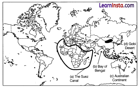
Class 8 World Geography Some Glimpses Extra Questions for Practice
Objective Type Questions
Question 1.
The Tibetan Plateau is often called the
(a) Roof of Africa
(b) Land of Fire
(c) Roof of the World
(d) Cold Desert
Question 2.
Which river flows through the Grand Canyon?
(a) Mississippi River
(b) Colorado River
(c) Amazon River
(d) Nile River
Question 3.
The Sahara Desert is mainly located in which continent?
(A) Asia
(b) Australia
(c) Africa
(d) South America
Question 4.
Which plateau is rich in minerals and located in western USA?
(a) Brazilian Plateau
(b) Deccan Plateau
(c) Colorado Plateau
(d) Arabian Plateau
Question 5.
The Amazon Raintorest ¡s Important because ¡t
(a) Is the driest place on Earth
(b) Produces large amounts of oxygen and supports biodiversity
(c) Is covered with ice throughout the year
(d) Has no rivers
Question 6.
Which desert is known as the drIest desert in the world?
(a) Sahara Desert
(b) Thar Desert
(c) Atacama Desert
(d) Gobi Desert
7. Match the Following.
| List I (River) | List II (Importance) |
| A. Nile River | 1. Flows through the Grand Canyon |
| B. Amazon River | 2. Lifeline of ancient Egyptian civilization |
| C. Colorado River | 3. Largest river by discharge |
| D. Danube River | 4. Important European trade route |
Codes
A B C D
(a) 2 3 1 4
(b) 3 1 2 4
(c) 2 4 3 1
(d) 1 3 2 4
Question 8.
Assertion (A): The Tibetan Plateau influences the climate of Asia.
Reason (R): It acts as a barrier and affects monsoon winds.
(a) Both A and R are true, and R is the correct explanation of A.
(b) Both A and R are true, but R is not the correct explanation of A.
(c) A is true, but R is False.
(d) A is false, but R is true.
Subjective Type Questions
Question 1.
What is meant by an oblate spheroid?
Question 2.
Name the largest ocean in the world.
Question 3.
What is a strait?
Question 4.
What is the difference between a bay and a gulf?
Question 5.
Discuss the causes and effects of desert formation, with reference to major deserts of the world.
Question 6.
Why are straits strategically important for international trade?
Question 7.
How does the Southern Ocean influence global ocean circulation?
Question 8.
Describe the climatic conditions and geographical importance of the Gobi Desert.
Question 9.
Discuss the role of rivers in shaping human civilisations.
Question 10.
Compare plains and plateaus in terms of physical features and human use.