Teachers guide students to use Exploring Society India and Beyond Class 8 Solutions and Class 8 Social Science SST Part 2 Chapter 7 India’s Urban Landscape Question Answer NCERT Solutions for quick learning.
India’s Urban Landscape Class 8 Questions and Answers
India’s Urban Landscape Class 8 Question Answer
The Big Questions (NCERT Page No. 191)
Question 1.
How do cities become the centre of diverse economic activities?
Answer:
Cities become the centres of diverse economic activities in the following ways
- Have better infrastructure like roads, railways, airports and ports.
- Provide markets for buying and selling goods.
- Offer job opportunities in industries, IT, trade, banking, and services.
- Attract migrants looking for employment and better living standards.
- Have educational institutions and skilled labour.
Question 2.
In what ways can urbanisation impact people’s lives?
Answer:
Urbanisation can impact people’s lives in the following ways
- Get better access to education and healthcare facilities.
- More employment opportunities in different sectors.
- Better transport and communication facilities.
- Face problems like overcrowding and traffic congestion.
- Experience higher pollution and increased cost of living.

Question 3.
What kind of challenges do cIties face in the 2ist century?
Answer:
In the 21st century, rapid urbanisation has created several challenges for cities. These include
- Air and water pollution.
- Traffic congestion.
- Housing shortages and the growth of slums.
- Pressure on basic infrastructure such as water, sanitation, energy, and transport.
- Waste management problems.
- Loss of green spaces and rising urban temperatures.
- Flooding during monsoons due to poor urban planning.
- Economic inequality and higher crime rates in some urban areas.
Question 4.
How can effective urban planning improve life in cities?
Answer:
Effective urban planning improve life in cities in the following ways
- It ensures that we have proper housing and sanitation facilities.
- It provides us with parks and green spaces for recreation.
- It improves public transport so that we can travel easily.
- It helps reduce pollution and protect the environment.
- It ensures that we use land and resources in a sustainable way.
Class 8 India’s Urban Landscape Question Answer
Let’s Explore (NCERT Page No. 192)
Question 1.
Where do you live? Is it a village, town, or city? In what ways can you differentiate between urban and rural areas? Write your observations and share with your classmates.
Answer:
I live in a town/city (students can write according to their place).
The differences between Urban and Rural Areas are as follows
| Urban Areas | Rural Areas |
| Have a large population. | Have a smaller population. |
| People work in different occupations such as business, industries, and services. | Most people are engaged in agriculture and related activities. |
| Better transport and communication facilities are available. | Transport and communication facilities are comparatively less developed. |
| Have more schools, hospitals, markets and government offices. | Have fewer public facilities and services. |
| Governed by elected local bodies such as Municipal Corporations or Municipal Councils. | Governed by Gram Panchayats. |
Observation: Urban areas are more developed and offer better infrastructure and employment opportunities, while rural areas have a peaceful environment and agriculture-based livelihoods.
Let’s Explore (NCERT Page No. 194-195)
Question 2.
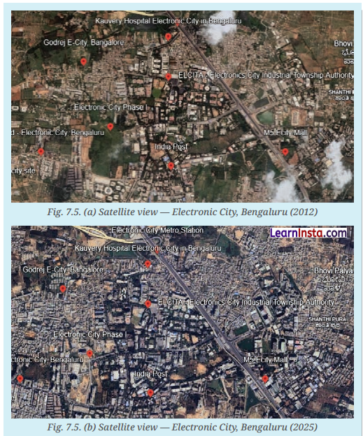
Observe and compare the two satellite ¡mages of an area of Bengaluru. They are from 2012 and 2025, respectively. What are your observations? What has changed? Guess what might be the causes for the change.
Answer:
A comparison of the two satellite images shows that Electronic City, Bengaluru, has undergone rapid urban development between 2012 and 2025.
The observations are as follows
- The 2025 image shows a significant increase in buildings, roads, and built-up areas.
- The area has become more densely populated, with fewer open and green spaces.
- Transport infrastructure has improved, indicating better connectivity and urban expansion.
The changes observed are given below
- Residential, commercial and industrial areas have expanded.
- Road networks and other urban infrastructure have developed.
- Open land has been converted into developed urban spaces.
Possible causes of the change are given below
- Rapid urbanisation and population growth.
- Expansion of IT industries, businesses and employment opportunities in Electronic City.
- Improved infrastructure and connectivity, which have attracted more people and investments to the area.
Let’s Explore (NCERT Page No. 203)
Question 3.
Can you name some towns and cities near you? Find out some interesting traditions, cuisines and customs specific to those areas and discuss them in class.
Answer:
Some towns and cities near me are Delhi, Gurugram, Faridabad, Rohtak, and Panipat.
- Delhi is famous for its historical monuments, diverse culture, and street food like Chole Bhature and Parathas.
- Gurugram is known for its modern lifestyle, corporate offices, and shopping malls.
- Panipat is famous for its handloom and textile industry.
- Rohtak is known for Haryanvi folk culture, traditional dances, and local cuisine such as Bajra Roti and Lassi.
- These places reflect India’s rich cultural diversity through their unique traditions, customs, and cuisines.
Question 4.
Observe the picture. Do you notice the other side of the city? What could be the possible challenges faced by people living in urban slums?

Answer:
People living in urban slums face several social and economic challenges due to overcrowding and lack of basic facilities. Some of these challenges are
- Poor and overcrowded housing in urban slums.
- Shortage of clean drinking water.
- Poor air quality and pollution.
- Inadequate sanitation and drainage facilities leading to floods during monsoons.
- Improper waste disposal, leading to unhygienic conditions.
- Reduced green spaces due to overcrowded houses.
- Higher risk of diseases due to unhealthy living conditions.
These challenges affect the health, safety, and overall quality of life of people living in urban slums.
Think About It (NCERT Page No. 193)
Question 1.
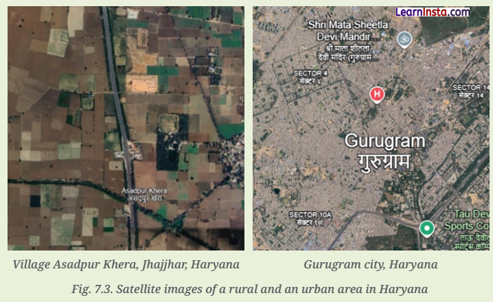
Given below figure shows the satellite view of a village and a City in Haryana, respectively. The larger blocks of green and brown land on the left in the village show open areas, whereas the grey built-up area on the right shows a complex network of buildings. What can you infer about the population density of the two regions? Why do you think such a difference exists?
Answer:
The satellite images show that the village has a low population density, as it has large open fields, fewer buildings, and more vacant land. In contrast, Gurugram city has a high population density, with closely built houses, roads, and commercial areas.
This difference is because cities offer better employment opportunities, educational and healthcare facilities, transport networks, and other modern amenities, which attract a larger population. Villages, on the other hand, have more open spaces and fewer people, resulting in lower population density.
Let’s Remember (NCERT Page No. 198)
Question 1.
What were the reasons that Surat became a textile manufacturing and diamond-cutting hub? (Hint: Recall from your Grade 7 Chapter ‘Understanding Markets’.)
Answer:
The reasons that Surat became a textile manufacturing and diamond-cutting hub are as follows
- Surat had skilled workers in the textile and diamond industries.
- It had good port facilities that supported trade.
- Traders and investors were attracted to the city.
- It became famous for diamond cutting and polishing.
- It had access to raw materials and large markets.
Class 8 SST Part 2 Chapter 7 Question Answer
Questions and Activities (Page No. 212-213)
Question 1.
What are some common features of cities?
Answer:
The common features of cities are as follows
- Cities have high population density, where many people live in a small area.
- Cities have well-developed infrastructure such as roads, bridges, flyovers, and public transport.
- Cities have industries, offices, shopping centres, and markets.
- Cities provide educational and healthcare facilities.
- Cities have municipal bodies that manage civic services.
Question 2.
Can you think of a city or town near you that has grown in population? What could be the underlying reasons for the urban migration?
Answer:
The city is Bengaluru.
- The reasons that Bengaluru has grown in population are as follows
- Many people migrate there for better job opportunities in IT parks.
- People move there for higher education and better healthcare facilities.
- The city provides better transport and communication facilities.
- Industrial growth and tourism have attracted workers from different regions.
Question 3.
With reference to the epigraph at the beginning of the chapter, who are the participants in the making of the
city and what could be their contribution?
Answer:
The participants in the making of a city and their contributions are as follows
- The government provides infrastructure and basic services.
- Urban planners design roads, housing layouts, and public spaces.
- Builders and workers construct buildings and other structures.
- Business owners create employment and economic activities.
- Residents contribute to the culture, economy, and social life of the city.
Question 4.
In what ways can urbanisation affect rural areas? Do cities also depend on rural areas? If yes, how? In what ways can rural and urban areas help each other develop?
Answer:
Urbanisation affects rural areas in many ways. It creates employment opportunities, improves transport and
communication, and encourages the development of education, healthcare and other services. However, it may
also lead to migration of people from villages to cities, reducing the rural workforce.
Yes, cities depend on rural areas. Rural areas provide
- Food supplies such as grains, fruits, vegetables, milk and other agricultural products.
- Raw materials required for industries.
- Labour for construction, manufacturing and other services.
- At the same time, rural and urban areas support each other’s development by
- Rural areas supply food, raw materials and labour, while urban areas provide markets, industries and services.
- Trade and transport strengthen economic links between rural and urban areas.
- Exchange of goods, services, knowledge and technology benefits both regions.
- Their mutual dependence promotes balanced, inclusive and sustainable development.
Question 5.
What is urban planning? What are the risks of ignoring sustainable urban planning as cities expand into villages and forest areas?
Answer:
Urban planning is the organised development and management of land, housing, transport and services in cities.
If we ignore sustainable urban planning, cities may face the following problems
- Face overcrowding and traffic congestion.
- Pollution levels may increase due to unplanned growth.
- Forests and agricultural lands may be destroyed.
- Slums may expand due to lack of proper housing.
Question 6.
Observe your own neighbourhood. What signs of good or poor planning do you notice? How do they affect daily life for you and others?
Answer:
The signs of good and poor planning in a neighbourhood are as follows
- Proper drainage systems and regular waste collection show good planning.
- Wide roads and street lighting improve safety and comfort.
- Traffic jams and waterlogging indicate poor planning.
- Encroachments and lack of green spaces affect daily life negatively.
Question 7.
Imagine you are an urban planner. What are the things you would consider to plan a city? Do groups like children, the elderly, and people with disabilities get easy access to parks, toilets, and public transport? What changes would you introduce to make it more Inclusive?
Answer:
The things I would consider while planning a city are as follows
- It ensure proper housing and sanitation facilities for everyone.
- Provide parks and playgrounds for children.
- It ensure ramps, lifts, and accessible toilets for elderly and disabled people.
- Improve public transport and footpaths for safe movement.
- It increases green cover to reduce pollution and heat.
Question 8.
Suppose your town, village or city has 100 people. Draw a rough map of the place on a graph paper. Imagine each square on the paper represents a specific area of the place, like residential neighbourhoods, parks, schools, factories, post offices and so on.
Now, distribute the 100 people throughout the area. You can decide where the people will live, whether they all live in the residential areas, or some live in the commercial or industrial areas. Write this number in each of the boxes.
In your depIction of the map, which areas are heavily populated and which are not? What were the reasons behind your choices of allocation of people?
Answer:
Sample distribution of 100 people is given below
| Area | Number of People |
| Residential neighbourhood | 70 |
| Commercial area | 10 |
| Industrial area | 8 |
| School | 3 |
| Hospital | 2 |
| Parks | 2 |
| Government offices/Post office | 3 |
| Total | 100 |
Heavily populated areas are
- Residential neighbourhoods
- Commercial areas
- Less populated areas are
- Industrial areas
- Schools
- Hospitals
- Parks
- Government offices/Post office
The reasons for the allocation are as follows
- Most people live in residential areas, making them the most populated.
- Commercial areas have fewer people because they are mainly workplaces and markets.
- Industrial areas are occupied only by workers during working hours.
- Schools, hospitals, parks, and government offices are public facilities visited only when required, so they have
a smaller population.
Question 9.
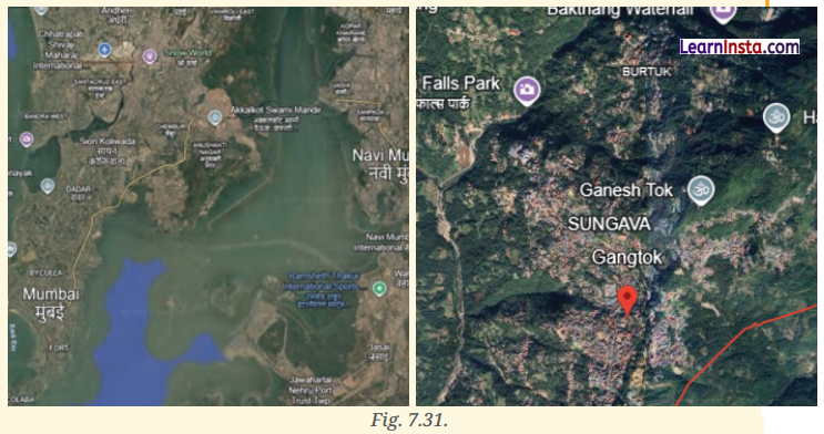
Observe the satellite view of Mumbai and Gangtok, respectively. Find out their population density and likely reasons for the difference.
Answer:
- Mumbai has a very high population density (over 20,000 people per sq. km approximately).
- Gangtok has much lower population density (around 300-400 people per sq. km approximately).
- The reasons for the difference in population density between Mumbai and Gangtok are as follows
- Mumbai has very high population density because it is the financial capital of India.
- Mumbai has limited land area but offers many job opportunities.
- Gangtok has lower population density because it is located in hilly terrain.
- Gangtok has fewer industries and less economic activity compared to Mumbai.
Question 10.
Find out how the city of Beijing, China, tackled the problem of air pollution. Prepare a report outlining measures that can be taken in India to mitigate air pollution in cities.
Answer:
Beijing introduced several effective measures to improve air quality, including
- Closing or relocating highly polluting industries.
- Replacing coal with cleaner fuels such as natural gas and electricity.
- Enforcing strict vehicle emission standards.
- Expanding public transport and encouraging the use of electric vehicles.
- Increasing green spaces through large-scale tree plantation.
- Continuously monitoring air quality and strictly enforcing environmental regulations.
The measures that can be taken by India to reduce air pollution in cities are as follows
- Promote the use of public transport, cycling and walking.
- Encourage the use of electric vehicles and cleaner fuels.
- Enforce strict emission norms for industries and vehicles.
- Increase tree plantation and develop more green spaces.
- Control construction dust and prohibit the open burning of waste.
- Improve waste management and encourage recycling.
- Raise public awareness about reducing air pollution.
- These measures can help create cleaner, healthier, and more sustainable cities.
Question 11.
Talk to a family or community member who has moved from a village to a city. Ask them the reason for the same and their experiences, challenges, and opportunities. How does city life compare to rural life?
Answer:
The reasons and experiences of migration are as follows
- People move to cities for better employment and education opportunities.
- They face challenges such as high living costs and
- They experience better income and exposure to modern facilities.
- City life is faster and more competitive compared to peaceful rural life.
Question 12.
Learn about urban planning in other cities around the world. In what ways can some of those aspects be adapted for a city near you?
Answer:
Cities like Singapore and Curitiba (Brazil) are known for their excellent urban planning. They have efficient public transport, well-planned roads, green spaces, and sustainable waste management systems.
These ideas can be adapted in Indian cities by
- Improving public transport and encouraging cycling and walking.
- Developing more parks and green spaces.
- Promoting better waste management and recycling.
- Using smart traffic management systems to reduce congestion.
- These measures can maké cities cleaner, safer and more sustainable.
Question 13.
Explore and suggest action points with respect to urban planning in cities to mitigate the challenges below and write a report. Two have been completed for you. Waste Management: Conducting a ‘Segregate at Source’ awareness drive in residential areas with demos on dry wet waste disposal and composting.
Traffic congestion: carpooling, high taxes on vehicle purchase, etc.
Inadequate safety of residents
Poor mobility within the city
Expansion of slums
Heat waves during summers
Answer:
- Inadequate Safety of residents: installing CCTV cameras, improving street lighting, and increasing police patrolling in vulnerable areas.
- Poor Mobility within the city: Developing integrated public transport systems with dedicated cycling tracks and pedestrian-friendly pathways.
- Expansion of Slums: Implementing affordable housing schemes and upgrading slum infrastructure with basic
amenities and sanitation facilities. - Heat Waves during Summers: Increasing urban green cover through tree plantation drives and promoting cool roofs and shaded public spaces.
Question 14.
Find out about a slum rehabilitation programme where people moved from slums to proper housing in your city. What do you think its possible benefits could be for the communities there?
Answer:
The benefits of slum rehabilitation programmes such as those implemented by the Slum Rehabilitation
Authority are as follows
- They provide proper housing to slum dwellers.
- They improve sanitation and hygiene conditions.
- They ensure better access to education and healthcare.
- They create safer and healthier living environments.
- They improve the overall quality of life for the community.