Class 6 Social Science Chapter 1 Notes Locating Places on the Earth
→ A Maps are representations or drawings of areas, showing locations and how to get to them.
→ An atlas is a book or collection of maps.
→ Physical maps show natural features like mountains, oceans, and rivers.
→ Political maps detail countries, states, boundaries, and cities.
→ Thematic maps provide specific information on various topics.
→ Three important components of maps are distance, direction, and symbols.
![]()
→ The scale of a map represents the ratio of a distance on the map to the actual distance on the ground.
→ For example, 1 cm on the map might represent 500 meters in reality.
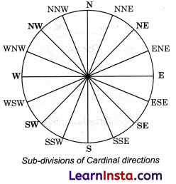
→ Cardinal directions are north, east, south, and west.
→ Intermediate directions include northeast (NE), southeast (SE), southwest (SW), and northwest (NW).
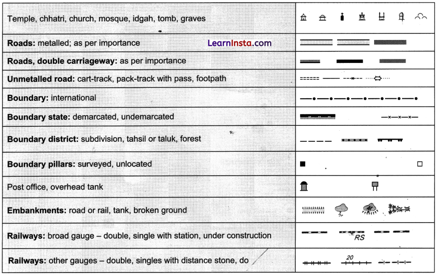
→ Symbols on maps represent features like buildings, roads, and natural elements.
→ Different countries use different sets of symbols; in India, these are standardized by the Survey of India.
→ Globes represent the Earth’s geography more accurately than flat maps due to their spherical shape.
→ Latitude measures the distance north or south from the Equator.
→ The Equator is at 0° latitude, while the poles are at 90°N and 90°S.
→ Climate varies with latitude; closer to the Equator is hot, moving towards the poles becomes temperate and then frigid.
→ Longitude measures the distance east or west from the Prime Meridian.
→ The Prime Meridian is at 0° longitude, and it passes through Greenwich, England.
→ Longitude values range from 0° to 180° east or west.
→ Latitude and longitude together can pinpoint any location on Earth.
→ Meridians of longitude are half-circles running from pole to pole.
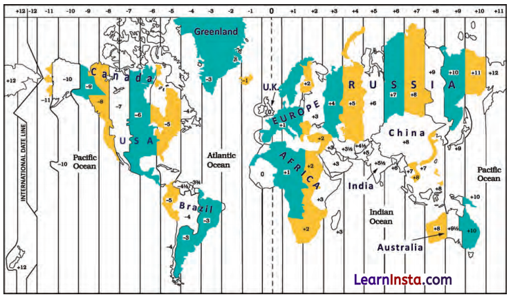
→ Time zones are based on meridians of longitude; the Earth is divided into 24 time zones, p Indian Standard Time (IST) is 5 hours 30 minutes ahead of Greenwich Mean Time (GMT).
→ The International Date Line, approximately at 180° longitude, changes the date when crossed.
→ Maps use a grid system of latitudes and longitudes to define locations precisely.
→ The Earth’s rotation is responsible for different times of the day around the world.
→ Longitude also marks time, as the Earth spins 15° per hour.
![]()
→ The Ujjain meridian was an ancient Indian prime meridian used for astronomical calculations.
→ Russia has the most time zones (11), while the USA has six.
→ Maps are crucial tools for understanding geography, locating places, and navigating through different areas.
→ Map : A representation or drawing of an area, showing physical features, distances, and directions.
→ Scale : The relationship between distance on a map and the actual distance on the ground.
→ Cardinal Directions : The four main points of a compass—North, East, South, and West.
→ Intermediate Directions : Directions between the cardinal points—Northeast (NE), Southeast (SE), Southwest (SW), and Northwest (NW).
→ Symbols : Used on maps to represent various features such as buildings, roads, and natural elements.
→ Grid : The network of latitude and longitude lines on a map or globe, the distance north or south of the Equator, expressed in degrees.
→ Longitude : Measures the distance east or west of the Prime Meridian, expressed in degrees.
→ Prime Meridian : The meridian designated as 0° longitude, passing through Greenwich, England. The imaginary line dividing the Earth into northern and southern hemispheres, at 0° latitude.
→ Meridians : Lines of longitude running from the North Pole to the South Pole.
→ Parallels : Lines of latitude running parallel to the Equator. ’
→ Atlas : A collection of maps in book form.
→ Physical Map : Shows natural features like mountains, rivers, and oceans.
→ Political Map : Shows boundaries, cities, and countries.
→ Thematic Map : Focuses on specific information such as climate, population, or economic activities.
![]()
→ International Date Line : The line of longitude at approximately 180°, where crossing it changes the date by one day.
→ Greenwich Mean Time(GMT) : The time at the Prime Meridian, used as a reference for time zones worldwide.
→ Indian Standard Time(IST) : The time zone used in India, 5.5 hours ahead of GMT.
→ Coordinates : The latitude and longitude that define a specific location on Earth.
→ Ujjayini Meridian : The ancient Indian prime meridian used by Indian astronomers.
→ Time Zones : Regions of the Earth that have the same standard time. .
→ Climate zones : Areas categorized by their climate, such as torrid, temperate, and frigid zones.
→ Globe : A spherical representation of the Earth with a map drawn on it.
→ Grid Lines : The intersecting lines of latitude and longitude on maps and globes that help determine locations.
Conventional Symbols