Students can access the CBSE Sample Papers for Class 12 Geography with Solutions and marking scheme Set 4 will help students in understanding the difficulty level of the exam.
CBSE Sample Papers for Class 12 Geography Set 4 with Solutions
Time : 3 Hours
Maximum Marks: 70
General Instructions :
- This question paper contains 30 questions. All questions are compulsory.
- This question paper is divided into five sections. Sections A, B, C, D, and E.
- Section A – Question number1 to 17 are Multiple Choice type questions carrying 1 mark each.
- Section B – Question number 18 and 19 are Source-based questions carrying 3 marks each.
- Section C – Question number 20 to 23 are Short Answer type questions carrying 3 marks each. Answer to these questions shall be written in 80 to 100 words.
- Section D – Question number 24 to 28 are Long Answer type questions carrying 5 marks each. Answer to these questions shall be written in 120 to 150 words.
- Section E – Question number 29 and 30 are Map-based questions.
Section-A (17×1=17 Marks)
Multiple Choice Questions
Question 1.
Consider the following statements and choose the correct answer with the help of given options. [1]
1. Assertion (A): The National Highways Authority of India (NHAI) was operationalised in 1995.
2. Reason (R): It is an autonomous body under the Ministry of Road Transport and Highway.
(a) Both the statements are true, statement 2 does not explain statement 1 correctly.
(b) Both the statements are true and statement 2 correctly explains the statement 1.
(c) Both statements 1 and 2 are wrong.
(d) Statement 1 is true and statement 2 is incorrect.
Answer:
(a) Both the statements are true, statement 2 does not explain statement 1 correctly.
Question 2.
Match Column (A) Types of Industries with Column (B) Characteristics and choose the correct option with the help of given Codes. [1]
| Column (A) | Column (B) |
| I. Cottage manufacturing | 1. Simple power-driven machines and semi-skilled labour |
| II. Small scale manufacturing | 2. Various raw materials, enormous energy, and specialised workers |
| III. Large scale manufacturing | 3. Use local raw materials and simple tools |
| IV. Cotton textile industry | 4. It has three sub-sectors i.e. handloom powerloom and mill sectors. |
Codes:
I II III IV
(a) 3 1 2 4
(b) 3 2 1 4
(c) 2 3 1 4
(d) 4 2 3 1
Answer:
(a) 3 1 2 4
Question 3.
New Zealand’s railways are mainly in the North Island to serve the ____________. [1]
(a) industrial areas
(b) mining areas
(c) farming areas
(d) urban areas
Answer:
(c) farming areas
Question 4.
The Union and Pacific Railway connects New York on the Atlantic Coast to _____________ Coast.
(a) San Francisco
(b) Los Angeles
(c) Vancouver
(d) California
Answer:
(a) San Francisco
Question 5.
Arrange the sequence of the steps involved in shaft mining. [1]
(i) The minerals then go through different stages of processing and refining.
(ii) Minerals are extracted and transported to the surface through these passages using specially designed lifts.
(iii) When the ore lies deep below the surface, underground mining/shaft method is used.
(iv) Vertical shafts have to be sunk, from where underground galleries radiate to reach the minerals.
Choose the correct option:
(a) (hi), (iv), (i), (ii)
(b) (iii), (iv), (ii), (i)
(c) (ii), (iii), (iv), (i)
(d) (iii), (ii), (iv), (i)
Answer:
(b) (iii), (iv), (ii), (i)
![]()
Question 6.
Medical tourism brings abundant benefits to developing countries like ___________. [1]
(a) India, Bangladesh, Myanmar
(b) China, Sri Lanka and Singapore
(c) Pakistan, Indonesia and India
(d) India, Thailand, Singapore and Malaysia
Answer:
(d) India, Thailand, Singapore and Malaysia
Question 7.
Considered the following statements and choose the correct answer from the given options: [1]
1. Human beings have evolved different methods of communication over times.
2. Initially, the means of communication were also the means of transportation.
Options:
(a) Only 1 is correct.
(b) Only 2 is correct.
(c) Both the statements are incorrect.
(d) Both the statements are correct and statement 2 is the correct explanation of statement 1.
Answer:
(d) Both the statements are correct and statement 2 is the correct explanation of statement 1.
Question 8.
Which one of the following is the main factor of the emergence of ports as gateways of international trade? [1]
(a) After the coming of the European traders.
(b) Since ancient times.
(c) After independence.
(d) After the coming of the Mughals.
Answer:
(a) After the coming of the European traders.
Question 9.
Which of the following is a person who works for at least 183 days (or six months) in a year? [1]
(a) Cultivators
(b) Agricultural labourers
(c) Marginal worker
(d) Main worker
Answer:
(d) Main worker
Question 10.
Which of the following mineral provides raw materials for the cement industry? [1]
I. Dolomite
II. Limestone
III. Granite
IV. Marble
Options:
(a) I and II
(b) I, II and III
(c) III and IV
(d) II, III and IV
Answer:
(a) I and II
![]()
Question 11.
According to the 2011 census, which of the following districts has the highest population density? [1]
(a) North-East Delhi
(b) Spiti
(c) Lahaul
(d) All of the above
Answer:
(a) North-East Delhi
Question 12.
Identify the incorrectly matched pair: [1]
| Year of Establishment | |
| (a) Atomic Energy Commission | 1948 |
| (b) Atomic Energy Institute at Trombay | 1954 |
| (c) Bhabha Atomic Research Centre | 1967 |
| (d) Oil and Natural Gas Commission | 1958 |
| Answer: (d) Oil and Natural Gas Commission |
1958 |
Question 13.
Consider the following statements: [1]
A. Public Sector Industries are owned and managed by governments.
B. Private Sector dominates the market in capitalist countries.
Choose the correct option.
(a) Only A is correct.
(b) Only B is correct.
(c) Both the statements are correct.
(d) Both the statements are incorrect.
Answer:
(c) Both the statements are correct.
Read the following case study and answer questions no. 15 to 17. Population growth in different parts of the world can be compared. The growth of population is low in developed countries as compared to developing countries. There is negative correlation between economic development and population growth. Although the annual rate of population change (1.4 percent) seems to be low (Source: Demographic Year Book, 2015), it is actually not so.
This is because:
(i) When a small annual rate is applied to a very large population, it will lead to a large population change.
(ii) Even if the growth rate continues to decline, the total population grows each year. The infant mortality rate may have increased as has the death rate during childbirth.
Question 14.
Which authority in case of the major ports decides the policy and plays regulatory functions? [1]
(a) Port Authority
(b) Local Authority
(c) State Authority
(d) Central Authority
Answer:
(d) Central Authority
![]()
Question 15.
What type of correlation exists between economic development and population growth? [1]
(a) Negative correlation
(b) Positive correlation
(c) Fluctuating correlation
(d) No correlation
Answer:
(a) Negative correlation
Question 16.
What will happen when a small annual rate is applied to a very large population? [1]
(a) It will lead to a small population change.
(b) It will lead to a negligible population change.
(c) It will lead to a large population change.
(d) It will lead to a very small population change.
Answer:
(c) It will lead to a large population change.
Question 17.
What will happen to the population even when the growth rate continues to decline? [1]
(a) A part of the population grows each year.
(b) The total population grows each year.
(c) A part of the population does not grow.
(d) The total population is affected by disease and death.
Answer:
(b) The total population grows each year.
Section-B (2×3=6 Marks)
Source-based questions
Question 18.
Read the passage carefully and answer the questions that follow: [3]
“Formal expression of religions on landscape is manifested through sacred structures, use of cemeteries and assemblages of plants and animals, groves of trees for religious purposes. Sacred structures are widely distributed throughout the country. These may range from inconspicuous village shrines to large Hindu temples, monumental masjids or ornately designed cathedrals in large metropolitan cities. These temples, masjids, gurudwaras, monasteries and churches differ in size, form, space-use and density, while attributing a special dimension to the total landscape of the area.”
(a) Name the most commonly followed religion in India.
(b) Name the major religions followed in India.
(c) State the significance of religious landscape.
Answer:
(a) Hinduism- with 79.8% of the Indian population.
(b) The major religions are- Hinduism, Islam, Sikhism, Christianity, Buddhism, Jainism, Zoroastrianism, Judaism and Teh Bahai.
(c) Religious landscape manifest the formal expression of religion through sacred structures, use of cemeteries and assemblages of plants and animals, groves of trees for religious purposes.
![]()
Question 19.
Study the picture given below and answer the following questions: [3]
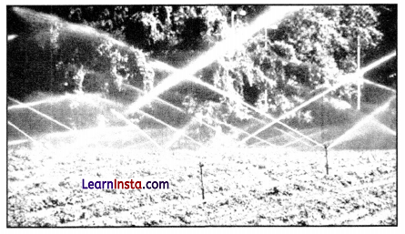
(a) Identify the type of irrigation shown in the diagram.
(b) Define the process.
(c) Define irrigation and also mention its main sources.
Answer:
(a) Sprinkler irrigation.
(b) Sprinkler irrigation is a method of providing rainfall-like irrigation to the crops. Water is distributed through a system of pipes usually by pumping. Spray heads at the outlets distribute the water over the entire soil surface and help to conserve water.
(c) The artificial method of watering the plants for assisting in their growth is called irrigation. Main sources of irrigation are wells, tube-wells, ponds, lakes, rivers.
Section-C (4×3=12 Marks)
Short Answer type questions
Question 20.
(A) “Physical environment has been greatly modified by human beings, it has also, in turn impacted human lives.” Explain the statement. [3]
OR
(B) Support the statement “Nature is extremely important to develop technology”.
Answer:
(A) Human geography deals with the inter-relationship between the physical environment and socio-cultural environment created by human beings through mutual interactions with each other. “The physical environment like landforms, soils, climate, water, natural vegetation and diverse flora and fauna has been greatly modified by human beings, which in turn, has also impacted human lives”. This statement absolutely makes sense because houses, villages, cities, road-rail networks, industries, farms, ports, things of our daily use and all other elements of material culture have been created by human beings using the resources provided by the physical environment.
OR
(B) Throughout history, humans have been innovating and refining technology. This continuous evolution of technology is deeply rooted in nature and its resources, such as wood, plastic, rubber, paper, and more. Without these natural elements, significant technological advancements would be nearly unattainable. The degree of technological progress is often a reflection of a society’s understanding and alignment with nature. A profound grasp of natural laws was crucial for early humans to begin their technological journey. Thus, true technological innovation emerges when humanity fully comprehends the intricacies of nature and its governing principles.
![]()
Question 21.
(A) Write three points on how can international trade be detrimental for countries. [3]
OR
(B) Assess the role of natural phenomenons in determining the level of international trade of a country.
Answer:
(A) International trade can prove to be detrimental to nations:
1. It leads to dependence of less developed countries on other more developed countries.
2. Resources are used faster than the rate of replenishment because composition to trade more, i.e., production increases.
3. Global trade also results in uneven development level in countries. Critics believe it creates situation where rich countries go richer and poor countries go poorer.
OR
(B) Natural phenomenons like geological structure and mineral reserves play a vital role:
1. Geological structure: It determines the mineral resource base and topographical differences ensure diversity of crops and animals raised. Lowlands have greater agricultural potential. Mountains attract tourists and promote tourism.
2. Mineral resources: They are unevenly distributed over the world. The availability of mineral resources provides the basis for industrial development.
Question 22.
Highlight the key aspects of the ‘Period of Population Explosion in India’. [3]
Answer:
The characteristics features of the ‘Period of Population Explosion in India’ are:
1. Decades 1951-1981 are referred to as the ‘Period of Population Explosion’.
2. Caused due to high natural growth rate, i.e., rapid decline in the mortality rate and high fertility rate of population in the country.
3. The development activities were introduced after independence economic graph showing up which ensure the improvement of living condition of people at large.
![]()
Question 23.
Evaluate the characteristics of India’s foreign trade. [3]
Answer:
1. Over time, the nature of India’s overseas trade has evolved. Despite the fact that the overall volume of imports and exports increased, the value of imports remained larger than the value of exports.
2. There has also been an increase in the trade deficit over the last couple of years because of the rise in crude oil prices, a key component of India’s international trade, is responsible for the deficit increase.
3. The percentage of primary goods in India’s overall export has declined over time, while the share of petroleum products has increased. At the same time, the share of manufactured items has remained constant.
Section-D (5×5=25 Marks)
Long Answer Type Questions
Question 24.
Discuss the world’s basic needs approach to human development. [5]
Answer:
The International Labour Organisation (ILO) was the first to suggest a basic needs approach to human development throughout the globe. The subject of human choice is neglected in this approach, as the primary focus is on meeting fundamental requirements. These absolute necessities are prerequisites for a person to sustain and meet their basic needs. In this method, six fundamental demands are included.
The following are their details:
- Maintaining a healthy weight necessitates good health.
- Schools and colleges provide education.
- Nutritious food that meets daily needs.
- Availability of Water: Drinking water that is safe to drink.
- To maintain hygiene, a proper sanitation system is required.
- A decent location to live with basic amenities.
![]()
Question 25.
(A) Explain trading services. [5]
OR
(B) Write a short note on services
Answer:
(A) Trade essentially includes buying and selling of items produced elsewhere for profit.
- It is conducted at certain places known as trading centres which are rural or urban. Rural marketing centres provide services to rural folk as per their needs, e.g., local mandis or periodic markets in rural areas, haats; urban marketing centres include Big Bazaar, polyclinics, etc.
- Trading is whole-sale or retail.
- Retail Trading: Goods are sold to consumers either in shops, i.e., retail stores or local departmental stores, chain stores (like Big Bazaar) or through non-store retail commerce, telephones, mail order or door-to-door services, street vendors.
- Wholesale Trading: Goods are procured in bulk from the producers or manufacturers on low rates and supplied to retailers. It also provides credit to retailers. Some big chains also procure goods on wholesale rates and sell them to consumers directly.
OR
(B) 1. Services occur at different levels. Some are geared to industry, some to people, and some to both industry and people, e.g., transportation system.
2. Low-order services, such as grocery shops and laundries are more common and widespread than high-order services.
3. High-order services are more specialised ones, like those of accountants, consultants and physicians.
4. Services are provided to individual consumers who can afford to pay for them. For example, gardeners, launderers and barbers primarily perform physical labour. Teachers, lawyers, physicians, musicians and others perform mental labour.
Question 26.
(A) “International trade has shown detrimental effects on under developed and developing economies”. Do you agree or not? Justify your stand. [5]
OR
(B) Categorise the ports on the basis of the specialised functions performed by them.
Answer:
(A) International trade can prove to be detrimental to nations in the following ways:
- Underdeveloped and developing nations depend upon developed nations because of their specialisation in the production process.
- International trade makes rich countries richer and leads to uneven global development.
- The third world countries commonly become the raw material suppliers to feed the industries of developed nations. For e.g., colonies of European countries.
- Underdeveloped nations, in order to compete global trade, increase their production activities by extracting the natural resources excessively.
- Organisations in such countries are focused only towards profit making, and environmental and health concerns are least concerned, which leads to serious implications in the future.
OR
(B) Types of port on the basis of their specialised functions performed by them:
- Oil Ports: These ports deal in the processing and shipping of oil. Some of these are tanker ports and some are refinery ports. Maracaibo in Venezuela, Esskhira in Tunisia, and Tripoli in Lebanon are tanker ports. Abadan on the Gulf of Persia is a refinery port.
- Ports of Call: These are ports which originally developed as calling points on main sea routes where ships used to anchor for refuelling, watering and obtaining food items. Later, they developed into commercial ports. Aden, Honolulu and Singapore are good examples of such ports.
- Packet Stations: These are also known as ferry ports. These packet stations are exclusively concerned with the transportation of passengers and mail across water bodies covering short distances. These stations are located in pairs in such a way that they face each other across the water body, e.g. Dover in England and Calais in France across the English Channel.
- Entrepot Ports: These are collection centres where goods are brought from different countries for export. Singapore is an entrepot for Asia, Rotterdam for Europe, and Copenhagen for the Baltic region.
- Naval Ports: These are ports which have only strategic importance. These ports serve warships and have repair workshops for them. Kochi and Karwar are examples of such ports in India.
![]()
Question 27.
(A) Give an estimate of the rice cultivated areas in India. [5]
OR
(B) What is Green Revolution? Explain the main features of the Green Revolution in India.
Answer:
(A) 1. Rice is a staple food for the overwhelming majority of the population in India. Though it is considered to be a crop of tropical humid areas, it has about 3,000 varieties that are grown in different agro-climatic regions. These are successfully grown from sea level to about 2,000 m altitude and from humid areas in eastern India to dry but irrigated areas of Punjab, Haryana, Western U.P., and Northern Rajasthan.
2. In Southern states and West Bengal, the climatic conditions allow the cultivation of two or three crops of rice in an agricultural year.
3. About one-fourth of the total cropped area in the country is under rice cultivation. West Bengal, Punjab, Uttar Pradesh, Andhra Pradesh and Tamil Nadu are five leading rice producing states in the country.
4. Rice cultivated in the irrigated areas of Punjab and Haryana was introduced in 1970s’ following the Green Revolution.
5. Genetically improved variety of seed, relative high usage of fertilisers and pesticide and lower levels of susceptibility of the crop to pests due to dry climatic conditions are responsible for higher yield of rice in this region.
OR
(B) The introduction of High Yielding Varieties (HYV) of seeds, along with the increased use of chemical fertilizers and irrigation, are collectively known as the Green Revolution. It facilitated the production increase necessary to make India self-sufficient in food grains, thus enhancing the agricultural sector. High-yielding wheat was first introduced to India in 1968 by the American agronomist Norman Borlaug. While Borlaug is hailed as the father of the Green Revolution globally, M.S. Swaminathan is recognised as the ‘Father of the Green Revolution in India’. Therefore, the Green Revolution refers to a new agricultural development strategy introduced in India in the late 1960s. It resulted in a significant boost in Indian food production.
- The primary characteristics of the Green Revolution in India include:
- High-yielding varieties of seeds that promised to produce much greater amounts of grain per plant.
- The application of advanced technology, the use of chemical fertilizers, pesticides, and a welldeveloped irrigation system.
- These measures addressed India’s food crisis, rendering the country self-sufficient in food grains.
- The revolution led to higher income growth and a reduction in poverty.
- It also paved the way for the commercialisation of agriculture. However, in many regions, the Green Revolution has been linked to loss of soil fertility due to the excessive use of chemical fertilizers. The persistent use of groundwater for tube-well irrigation has also depleted subterranean water levels.
![]()
Question 28.
“Slums have evolved as one of the biggest causes behind rapid environmental degradation in the urban centres.” Justify. [5]
Answer:
Slums are one of the biggest causes of rapid degradation in the urban environment. It affect the environment of urban centres adversely in the following ways:
- Unplanned Development: Unplanned and uncontrolled rise of the infrastructure of slums, often through landfill and ‘concrete jungle’ consequently results into land, air and water pollution.
- Loss of Green Cover: Master Plan of any city is developed keeping in mind the natural growth rate of population in the city but the outward expansion of the city due to the rise of slums on the outer edge disturbs the Master Plan as the expansion takes place at the cost of the nearby agricultural land and other forms of green cover, which eventually causes land and air pollution.
- Excessive Waste Generation: Slums generate the largest share of the total solid waste in an urban agglomeration. This waste is not disposed properly and left unattended on the ground, which is the biggest cause of land pollution in urban centres.
- Depletion in Quality and Quantity of Resources: Extremely high density of population in the slums has resulted into undue and immense pressure on land and water resources.
- Overall Critical Levels of Pollution: Rise and existence of slums results in increased congestion, sewage, waste generation, concrete infrastructure and traffic which in turn cause an increase in environmental degradation and pollution, in general.
Section-E (2×5=10 Marks)
Map-based questions
Question 29.
On the given political map of the world, the following seven features are shown. Identify any five of these features and write their correct names on the lines marked near each feature. [5]
A. The country with the lowest density of population in Asia.
B. Name the country with the smallest population of Asia.
C. A port on Southern end of South Africa.
D. A port on South Pacific Coast in Australia.
E. Important Iron and steel centre in U.K.
F. The region responsible for 80 per cent of Germany’s total steel production.
G. Eastern terminal of Trans-Siberian Railway.
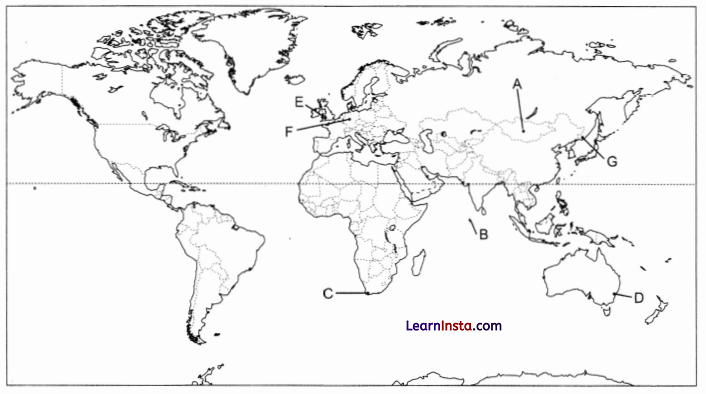
Answer:
A. Mongolia
B. Maldives
C. Cape Town
D. Sydney
E. Port Talbot
F. Ruhr region
G. Vladivostok
![]()
Question 30.
On the given political map of India, locate and label any five of the following with appropriate symbols: [5]
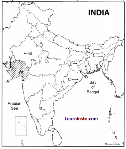
A. Identify the state of India that utilised underground at a moderate rate.
B. Choose the town which has been known as a tourist destination in Rajasthan.
C. Identify the town which has been developed as administrative headquarters.
D. Manganese mines of Odisha.
E. Copper mines of Jharkhand.
F. The oldest operational port in India.
G. Identify the port that was built during the India-Pakistan partition.
Answer:
A. Gujarat
B. Jodhpur
C. Bhubaneshwar
D. Mayurbhanj
E. Hazaribagh
F. Kolkata port trust
G. Kandala port