Students can access the CBSE Sample Papers for Class 12 Geography with Solutions and marking scheme Set 2 will help students in understanding the difficulty level of the exam.
CBSE Sample Papers for Class 12 Geography Set 2 with Solutions
Time : 3 Hours
Maximum Marks: 70
General Instructions :
- This question paper contains 30 questions. All questions are compulsory.
- This question paper is divided into five sections. Sections A, B, C, D, and E.
- Section A – Question number1 to 17 are Multiple Choice type questions carrying 1 mark each.
- Section B – Question number 18 and 19 are Source-based questions carrying 3 marks each.
- Section C – Question number 20 to 23 are Short Answer type questions carrying 3 marks each. Answer to these questions shall be written in 80 to 100 words.
- Section D – Question number 24 to 28 are Long Answer type questions carrying 5 marks each. Answer to these questions shall be written in 120 to 150 words.
- Section E – Question number 29 and 30 are Map-based questions.
Section-A (17×1=17 Marks)
Multiple Choice Questions
Question 1.
Consider the following statements and choose the correct answer with the help of given options. [1]
1. Assertion (A): Air transport is the slowest means of movement from one place to the other.
2. Reason (R): It is not essential for a vast country like India, where distances are large and the terrain
and climatic conditions are diverse.
(a) Both the statements are true, statement 2 does not explain statement 1 correctly.
(b) Both the statements are true and statement 2 correctly explains the statement 1.
(c) Both statements 1 and 2 are wrong.
(d) Statement1 is true and statement 2 is incorrect.
Answer:
(c) Both statements1 and 2 are wrong.
Question 2.
Match the following: [1]
| List I (Ports) | List II (City) |
| (i) Esskhira | 1. Lebanon |
| (ii) Tripoli | 2. Tunisia |
| (iii) Dover | 3. France |
| (iv) Ealais | 4. England |
(a) (i)-1, (ii)—2, (iii)—3, (iv)-4
(b) (i)-4, (ii)—3, (iii)—2, (iv)-1
(c) (i)-2, (ii)-1, (iii)-4, (iv)-3
(d) (i)-2, (ii)—3, (iii) —4, (iv)-1
Answer:
(c) (i)-2, (ii)-1, (iii)-4, (iv)-3
Question 3.
Secondary activities add value to natural resources by ____________raw materials into valuable products. [1]
(a) refining
(b) transforming
(c) manufacturing
(d) developing
Answer:
(b) transforming
Question 4.
Which one of the following commodity of India’s export has declined over the years during 2009-17? [1]
(a) Agriculture and allied products
(b) Petroleum and crude products
(c) Ore and Minerals
(d) Manufactured goods
Answer:
(c) Ore and Minerals
Question 5.
Which of the following months of the year are included in Kharif Cropping Season? [1]
(a) June-September
(b) October- March
(c) April-June
(d) July- October
Answer:
(a) June-September
Question 6.
What are ‘mandis’? [1]
(a) Local transport hub
(b) Rural wholesale markets
(c) Local raw material markets
(d) Rural retailing areas
Answer:
(b) Rural wholesale markets
Question 7.
Wooden furniture industry is an example of __________ industries. [1]
(a) chemical based
(b) agro based
(c) forest based
(d) mineral based
Answer:
(c) forest based
Question 8.
“Primitive societies primarily sustained themselves through hunting as a way of life in regions characterised by which combination of climates?” [1]
(a) Very cold climate
(b) Extremely hot climate
(c) Very cold and extremely hot climates
(d) Wet and moderate climates
Answer:
(c) very cold and extremely hot climates
Question 9.
Governments adopt _____________ to promote ‘balanced’ economic development and hence set up industries in particular areas. [1]
(a) ‘national policies’
(b) ‘subsidised policies’
(c) ‘import policies’
(d) ‘regional policies’
Answer:
(d) ‘regional policies’
Question 10.
Which of the following is not matched correctly? [1]
| Ways of Transport | Medium of Transport |
| (a) Ropeways | Waterways |
| (b) Highways | Landways |
| (c) Cableways | Landways |
| (d) Pipeline | Landways |
Answer:
| Ways of Transport | Medium of Transport |
| (a) Ropeways | Waterways |
Question 11.
The average density of population of India in 2011 is ____________ persons per square km. [1]
(a) 216
(b) 382
(c) 300
(d) 314
Answer:
(b) 382
Question 12.
Every road that joins two nodes is called a __________. [1]
(a) route
(b) link
(c) node
(d) network
Answer:
(b) link
Question 13.
Which state has the highest density of population? [1]
(a) Bihar
(b) Haryana
(c) Uttar Pradesh
(d) West Bengal
Answer:
(a) Bihar
Question 14.
What is the major commodity that has been exported from New Manglore Ports? [1]
(a) Iron ore
(b) Coal
(c) Manganese
(d) Micro
Answer:
(a) Iron ore
Read the following case study and answer questions no. 15 to 17.
Benda lives in the wilds of the Abujh Maad area of Central India. His village consists of three huts deep in the wilds. Not even birds or stray dogs that usually crowd villages can be seen in these areas. Wearing a small loin cloth and armed with his axe he slowly surveys the penda (forest) where his tribe practices a primitive form of agriculture called shifting cultivation. Benda and his friends bum small patches of forest to clear them for cultivation. The ash is used for making the soil fertile. Benda is happy that the Mahua trees around him are in bloom. How lucky I am to be a part of this beautiful universe, he thinks as he looks up to see the Mahua, Palash and Sal trees that have sheltered him since childhood. Crossing the penda in a gliding motion, Benda makes his way to a stream. As he bends down to scoop up a palmful of water, he remembers to thank Loi-Lugi, the spirit of the forest for allowing him to quench his thirst. Moving on with his friends, Benda chews on succulent leaves and roots. The boys collect Gajjhara and Kuchla, from the forest. These are special plants that Benda and his people use. He hopes the spirits of the forest will be kind and lead him to these herbs. These are needed to barter in the madhai or tribal fair coming up the next full moon.
Question 15.
In what type of a settlement does Benda live? [1]
(a) A rural settlement near the forest.
(b) A forested village in the midst of a small town.
(c) A large primitive village in a forest consisting of several huts.
(d) A small primitive village in the wild consisting of a few huts.
Answer:
(d) A small primitive village in the wild consisting of a few huts.
Question 16.
Which type of primitive agriculture does the tribe practice? [1]
(a) Subsistence agriculture
(b) Shifting cultivation
(c) Intensive agriculture
(d) Crop rotation
Answer:
(b) Shifting cultivatio
Question 17.
Why did Benda thank Loi-Lugi, after drinking water from the stream? [1]
(a) Because he was extremely thirsty.
(b) Because he forgot to carry water along with him.
(c) Because his tribe worships ‘Mother Nature’ which provides everything for their survival.
(d) Because if he did not thank Loi-Lugi, the forest spirit would get angry.
Answer:
(c) Because his tribe worships ‘Mother Nature’ which provides everything for their survival.
Section-B (2×3=6 Marks)
Source-based questions
Question 18.
Read the passage carefully and answer the questions that follow: [3]
Patterns of population distribution and density help us to understand the demographic characteristics of any area. The term population distribution refers to the way people are spaced over the earth’s surface. Broadly, 90 percent of the world population lives in about 10 percent of its land area. The 10 most populous countries of the world contribute about 60 percent of the world’s population. Of these 10 countries, 6 are located in Asia.
(a) What help us to understand the demographic characteristics of any area?
(b) Explain the term population distribution.
(c) What percentage does the 10 most populous countries of the world contribute?
Answer:
(a) Patterns of population distribution and density help us to understand the demographic characteristics of any area.
(b) The term population distribution refers to the way people are spaced over the earth’s surface.
(c) The 10 most populous countries of the world contribute about 60 percent of the world’s population.
Question 19.
Observe the given map and answer the following questions: [3]
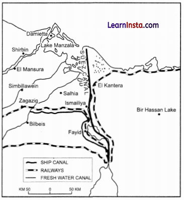
(a) Identify and name the canal shown in the map.
(b) This canal connect which two sea?
(c) Write any two characteristics of this canal.
Answer:
(a) The canal shown in map is Suez Canal, constructed in 1869 between Port Said and Port Suez in Egypt.
(b) Suez canal linking the Mediterranean sea and the red sea.
(c) The main characteristics of this canal are :
1. It provides Europe a new gateway to the Indian Ocean and reduces sea-route distance between Liverpool and Colombo by 6400 km compared to the Cape of Good Hope route.
2. About 100 ships travel daily and each ship takes around 10-12 hours to cross the canal.
Section-C (4×3=12 Marks)
Short Answer type questions
Question 20.
(A) Where do we find clustered settlements in India? Explain their features. [3]
OR
(B) Explain any three features of urban settlement in India?
Answer:
(A) Clustered settlements are predominantly found in the fertile alluvial plains and the northeastern states of India. For instance, people in the Bundelkhand region of central India and Nagaland primarily live in compact villages due to security or defense reasons. In areas like Rajasthan, water scarcity has driven the formation of compact settlements to optimise the use of available water resources.
The features of clustered settlements are:
1. They are regions with a dense population or a closely built-up area of houses.
2. The residential area is clearly demarcated and separated from the surrounding fields and pastures.
3. The densely populated area and its connecting roadways usually exhibit a distinct pattern or geometric shape, which can be rectangular, radial, or linear.
OR
(B) Features of urban settlement in India are:
1. Technology and man-made objects have a close association with urban communities.
2. In these places, the majority of individuals are involved in secondary, tertiary, and quaternary activities.
3. The settlement is vast, and the population density is considerable.
Question 21.
What are the main functions of the National Highway Authority of India (NHAI)? [3]
Answer:
National Highway Authority of India was constituted by an act of Parliament in1988 and set up in 1995.
1. It works as an autonomous body under the Ministry of Road Transport and Highway.
2. It is entrusted with the responsibility of development, maintenance and operation of National Highways.
3. It is the apex body responsible for maintenance and improving the quality of the National Highways.
Question 22.
(A) Mention the types of changes that an economy undergoes, which affect the land use of the region. [3]
OR
(B) Why has the Green Revolution strategy in India been more successful in northern India?
Answer:
(A) Following are the type of changes that an economy undergoes that affect land use:
1. The size of the economy.
2. The composition of the economy.
3. The contribution of the agricultural activities.
OR
(B) In Punjab, Haryana, and western Uttar Pradesh, more than 85 per cent of net sown area is under irrigation. The High-yielding varieties of crops need regular moisture supply, which is made possible only by developed irrigation systems. Hence, the green revolution strategy of agriculture development has been more successful in Punjab, Haryana, and western Uttar Pradesh.
Question 23.
Distinguish between Population Density, Physiological Density and Agricultural Density. [3]
Answer:
Population Density is expressed as the number of persons per unit area.
Population Density = Total Population in a Region
Area of Respective Region (in sq. km.)
Physiological Density is the number of persons in a region per net cultivated area.
Physiological Density = Total Population
Net Cultivated Area (in sq. km.)
Agricultural Density is the number of the total agricultural population including cultivators, agricultural labourers and their families per net cultivated area.
Agricultural Density = Total Agricultural Population
Net Cultivated Area (in sq. km.)
Section-D (5×5=25 Marks)
Long Answer Type Questions
Question 24.
“90 percent of the world population lives in about10 percent of its total land area, whereas the remaining 10 per cent population resides in the 90 percent of its land area”. Support the statement with suitable examples. [5]
Answer:
Example that support the statement are given below:
1. Cultural Factors: The Traditions and culture of a place includes the distribution of a population. People like to migrate in areas where common tradition and culture are found.
2. Physical Factors: Relief, climate, soil and mineral are the physical factors that determine the population of any place. Tibet is the region of very less population, whereas Indo-Gangetic plain is overpopulated.
3. Means of Transport: Regions with better facilities of means of transport lead to a better economic condition. This lead to a thick population. Mumbai-Pune Industrial region is the best example.
4. Economic Condition: Industrial and agricultural regions of the world are thickly populated. Industrial region of India, USA, Japan, UK are the examples.
Question 25.
(A) Discuss in detail three prime about Trans- Continental Railways. [5]
OR
(B) Discuss the importance of Inland Waterways.
Answer:
(A) Trans-continental railways run across the continent and link its two ends.
The following are the most important of these:
1. Trans-Siberian Railways: This is a major rail route of Russia that runs from St. Petersburg in the west to Vladivostok on the Pacific Coast in the east passing through Moscow, Ufa, Novosibirsk, Irkutsk, Chita and Khabarovsk. It is the most important route in Asia and also the longest (9,332 km) double-tracked and electrified trans-continental railway in the world.
2. Trans-Canadian Railways: This 7,050 km long rail-line in Canada runs from Halifax in the east to Vancouver on the Pacific Coast passing through Montreal, Ottawa, Winnipeg and Calgary. It was constructed in 1886, it connected the Quebec-Montreal Industrial Region with the wheat belt of the Prairie Region and the Coniferous Forest Region in the north.
3. The Union and Pacific Railways: This rail-line connects New York on the Atlantic Coast to San Francisco on the Pacific Coast passing through Cleveland, Chicago, Omaha, Evans, Ogden and Sacramento. The most valuable exports on this route are ores, grain, paper, chemicals and
machinery.
OR
(B) The importance of Inland waterways are:
1. Rivers, canals, lakes and coastal areas have been important waterways since time immemorial. Boats and steamers are used as means of transport for cargo and passengers.
2. Rivers are the only means of transport in dense forests. Very heavy cargo like coal, cement, timber and metallic ores can be transported through inland waterways.
3. The Maintenance cost of inland waterways is also very less as compared to roadways and railways.
4. This mode of internal transportation has way less risk than roadways, railways and airways with highest fuel efficiency.
Question 26.
What are the uses of Manganese? Also, write about two leading states in India that produce Manganese. [5]
Answer:
The uses of Manganese include:
1. Serving as an essential raw material in the smelting of iron ore and in the manufacturing of ferrous alloys.
2. Being a component in standard disposable batteries.
Two leading states in India that produce Manganese are:
1. Odisha: While Manganese deposits can be found in almost all geological formations, they are primarily associated with the Dharwar system. Odisha stands out as the foremost producer of Manganese. Notable mines are situated in the central part of the iron ore belt of India, especially in areas like Bonai, Kendujhar, Sundergarh, Gangpur, Koraput, Kalahandi, and Bolangir.
2. Karnataka: This state is another significant producer of Manganese. The mines here are primarily located in regions like Dharwar, Ballari, Belagavi, North Canara, Chikmagalur, Shivamogga, Chitradurg, and Tumkuru.
Question 27.
(A) Describe any five health effects of air pollution. [5]
OR
(B) “Slums are one of the root causes behind the increasing crime rates in the major cities of India.”
Explain with examples.
Answer:
(A) Following are the health effects of air pollution:
1. Respiratory Diseases: There is a significant rise in the cases of respiratory diseases such asthma, whooping cough, pneumonia, chronic obstructive pulmonary diseases and other lung diseases.
2. Cardio-Vascular Diseases: Stroke and heart diseases like high blood pressure, heart attacks, etc. are one of the main health consequences of air pollution, and have a high rate of fatality due to inhaling harmful, toxic pollutants in the air.
3. Decreasing Immunity: The toxic gases cause harm to the white-blood cells in the body, depleting the natural immunity of the body. Air pollution is also a cause of blood cancer and other blood-related diseases.
4. Neurological Diseases: Severe headaches, migraines, loss of neural cells, declined cognition and dementia are pollution-induced nervous system dysfunction continuous exposure to particulate matter reduces white and grey matter in the brain resulting in such neurological diseases.
5. Psychological Diseases: Stress-induced depression, anxiety, autism, Parkinson’s, Alzheimer’s, mood and behavioural changes are only a few psychological consequences of air pollution.
OR
(B) Slums play a significant role in the escalating crime rates in India’s major cities. Many slum-dwellers face extreme poverty, unemployment, and substandard living conditions. Such circumstances make them more susceptible to drug abuse, alcoholism, human trafficking, vandalism, and overall social exclusion. The lack of education among the residents, compounded by their inability to provide proper education to their children, further intensifies their vulnerability to criminal activities. Some examples include:
1. Mumbai, often referred to as the ‘City of Slums’, consistently ranks among the top three cities in India for its high crime rates. The city witnesses elevated rates of theft, murder, extortion, and crimes against women.
2. Delhi, with one of the highest crime rates in the country, sees its outskirts plagued with incidents of kidnapping, extortion, theft, robbery, and crimes targeting women and the elderly.
3. The rampant growth and expansion of slums in India’s metropolises also contribute to the rise in crimes like child labour, begging, and human trafficking.
Question 28.
(A) “There is low yield per acre but high yield per person.” Which type of agriculture is being talked about here? Give a detail brief about this type of agriculture. [5]
OR
(B) What has led to groundwater depletion in the northern states of India?
Answer:
(A) Commercial grain cultivation is the type of agriculture is being talked about here. Main features of this type of agriculture are:
- The size of the farm is very large.
- All operations of cultivation from ploughing to harvesting are mechanised.
- There is low yield per acre but high yield per person.
- In the areas practising commercial grain cultivation, the areas of production are high, as the farming is intensive, but due to low population and high degree of mechanisation, the number of people employed in these farms is less.
- Due to high level of scientific and technological skills employed in the production activities, the overall yield is high.
- Commercial grain cultivation is practiced in the interior parts ofsemi-arid lands of the multitudes.
- Wheat is the principal crop. However, other crops like com, barley, oats and rye are also grown.
- This type of agriculture is largely practised in Eurasian Steppes, the Canadian and American Prairies, the Pampas of Argentina, the Velds of South Africa, the Australian Downs and the Canterbury Plains of New Zealand.
OR
(B) Several factors have contributed to the depletion of groundwater in the northern states of India:
- Northern states such as Punjab, Haryana, and Western Uttar Pradesh have over 85% of their net sown area under irrigation. This irrigation predominantly comes from wells and tube wells.
- The Green Revolution introduced water-intensive crops to regions that are naturally droughtprone and water-deficit. This resulted in the over-extraction of groundwater.
- The continuous pumping of water from the ground without allowing adequate time for its replenishment results in rapid depletion.
- Subsidies on electricity and high Minimum Support Prices (MSP) for water-intensive crops are additional reasons for excessive groundwater extraction.
- Water contamination, as seen in pollution from landfills, septic tanks, leaking underground gas tanks, and the overuse of fertilisers and pesticides, has further damaged and depleted groundwater resources.
Section-E (2×5=10 Marks)
Map-based questions
Question 29.
On the given political map of the world, the following seven features are shown. Identify any five of these features and write their correct names on the lines marked near each feature. [5]
A. An industrial port of South Asia
B. An important country of commercial livestock rearing.
C. A commercial port on Red Sea
D. A port on Pacific coast of Canada
E. A major area of commercial livestock rearing.
F. A port of call in Yemen
G. A port on the South Atlantic Coast of Brazil
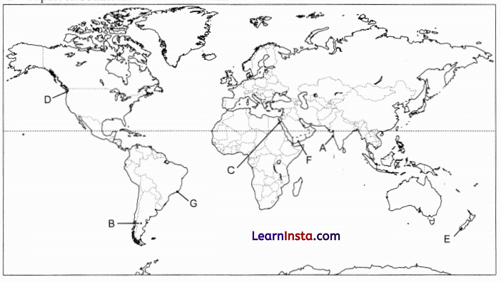
Answer:
A. Mumbai
B. Argentina
C. Suez
D. Vancouver
E. New Zealand
F. Aden
G. Rio De Janeiro
Question 30.
On the given political map of India, locate and label any five of the following with appropriate symbols: [5]
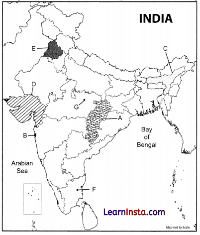
A. Identify the state where hamleted settlements are found in India.
B. Identify the largest agglomeration city in India?
C. The state, which is the leading producer of tea in north-eastern India.
D. Identify the state of western India that grows sugarcane.
E. Identify the state of India that has the highest utilisation of groundwater.
F. Coal mines of Tamil Nadu.
G. Bauxite mines of Madhya Pradesh.
Answer:
A. Chhattisgarh
B. Greater Mumbai
C. Assam
D. Gujarat
E. Punjab
F. Neyveli
G. Katni