Students can access the CBSE Sample Papers for Class 12 Geography with Solutions and marking scheme Set 1 will help students in understanding the difficulty level of the exam.
CBSE Sample Papers for Class 12 Geography Set 1 with Solutions
Time : 3 Hours
Maximum Marks: 70
General Instructions :
- This question paper contains 30 questions. All questions are compulsory.
- This question paper is divided into five sections. Sections A, B, C, D, and E.
- Section A – Question number1 to 17 are Multiple Choice type questions carrying 1 mark each.
- Section B – Question number 18 and 19 are Source-based questions carrying 3 marks each.
- Section C – Question number 20 to 23 are Short Answer type questions carrying 3 marks each. Answer to these questions shall be written in 80 to 100 words.
- Section D – Question number 24 to 28 are Long Answer type questions carrying 5 marks each. Answer to these questions shall be written in 120 to 150 words.
- Section E – Question number 29 and 30 are Map-based questions.
Section-A (17×1=17 Marks)
Multiple Choice Questions
Question 1.
Consider the following statements and choose the correct answer with the help of given options. [1]
1. Assertion: High level of human development group has 53 countries.
2. Reason: A higher investment in people and good governance has set this group apart from others. Options:
(a) Both the statements are true, statement 2 does not explain statement 1 correctly.
(b) Both the statements are true and statement 2 correctly explains the statement 1.
(c) Both statements 1 and 2 are wrong.
(d) Statement 1 is true and statement 2 is incorrect.
Answer:
(b) Both the statements are true and statement 2 correctly explains the statement 1
Explanation:
Statement 1: “This statement implies the existence of a group of countries with high levels of human development.” The Human Development Index (HDI) is a metric that measures a country’s overall accomplishment in three important dimensions: area of health, education and access to resources
Statement 2: “A higher investment in people and good governance has set this group apart from others.” This statement explains why the group of 53 countries has a high degree of human development. It relates the high HDI ratings to two important factors:
(a) Greater investment in people: This suggests that these countries prioritise investments in healthcare, education, and social welfare programmes to improve the well-being and capabilities of their citizens.
(b) Good governance: Good governance refers to the practical and responsible management of public resources and institutions, ensuring that policies and programmes are well-implemented for the benefit of the people. It is critical to promoting development and social progress. The reason (Statement 2) provides a clear explanation for why the group of 53 countries has a high level of human development (Statement 1). As both statements are true and the second statement correctly explains the first one, Option B is the correct answer.
Question 2.
Consider the following and choose the correct answer with the help of given codes – [1]
| STAGES OF POPULATION | GROWTH FEATURES |
| I Period between 1901 to 1921 | 1. Period of steady growth |
| II Period between 1921 to 1951 | 2. Phase of stagnant growth of population |
| III Period between 1951 to 1981 | 3. High but decreasing growth rate |
| IV After 1981 till present | 4. Period of population explosion |
Options:
| I | II | III | IV |
| (a) 1 | 2 | 3 | 4 |
| (b) 2 | 1 | 4 | 3 |
| (c) 4 | 3 | 2 | 1 |
| (d) 2 | 1 | 3 | 4 |
| Answer: (b) 2 |
1 | 4 | 3 |
Explanation:
(i) Between 1901 and 1921, India experienced a stagnant or stationary phase of population growth. The growth rate was very low and even negative during 1911-1921. Both high birth and death rates contributed to the slow increase in population.
(ii) From 1921 to 1951, India saw steady population growth due to improved health and sanitation facilities, leading to a decline in mortality rates.
(iii) From 1951 to 1981, India faced a population explosion caused by a rapid decline in mortality rates, coupled with a high fertility rate.
(iv) After 1981 till the present, although the growth rate remained high, it gradually started slowing down. This was attributed to a decrease in crude birth rate, influenced by increased age at marriage and improved quality of life, particularly in female education.
![]()
Question 3.
Maracaibo, Esskhira and Tripoli ports are classified as: [1]
(a) Ports of Call
(b) Naval Ports
(c) Oil Ports
(d) Entrepot ports
Answer:
(c) Oil Ports
Explanation: Maracaibo, Esskhira, and Tripoli ports are classified as “Oil Ports” because they are crucial in handling and exporting oil and petroleum-related products.
Question 4.
Consider the following statements and choose the correct answer with the help of given Option: [1]
I. The resource-intensive approach of modern expensive agriculture has become unmanageable for marginal and small farmers due to very meager or no savings to invest in agriculture.
II. Most of such farmers have resorted to availing credit from various institutions and money lenders but crop failures and low returns from agriculture have forced them to fall into the trap of indebtedness.
Options:
(a) Both the statements are true.
(b) Only statement I is true.
(c) Only statement II is true
(d) Both the statements are wrong.
Answer:
(a) Both the statements are true.
Explanation:
(i) The first statement highlights that the resource-intensive approach of modem expensive agriculture has become unmanageable for marginal and small farmers. These farmers often lack sufficient savings to invest in agriculture, which makes it difficult for them to adopt costly modern farming practices and technologies.
(ii) The second statement is about how these small farmers, facing financial constraints, resort to availing credit from various sources, including formal institutions and money lenders, to meet their agricultural expenses. However, due to factors like crop failures and low returns from agriculture, they find themselves trapped in a cycle of debt. Both statements highlight the challenges faced by marginal and small farmers in modern agriculture, particularly in terms of financial limitations and the cycle of indebtedness they often find themselves in.
Question 5.
Given below is a list of pillars of human development and its indicators. Which of the following pair is NOT correctly matched? [1]
(a) Equity – Making equal access to opportunities available to everybody
(b) Sustainability – Continuity in the availability of opportunities
(c) Productivity – Resources must be used keeping in mind the future
(d) Empowerment – To have the power to make choices
Answer:
(c) Productivity – Resources must be used keeping in mind the future
Explanation: This pair is NOT correctly matched because the concept provided for productivity does not accurately represented. Instead, productivity refers to the efficiency and effectiveness with which resources (such as labour, capital, and technology) are utilized to produce goods and services. Higher productivity implies achieving more output with the same or fewer resources.
Question 6.
Which one of the following is the largest linguistic group of India? [1]
(a) Sino- Tibetan
(b) Austric
(c) Indo- Aryan
(d) Dravidian
Answer:
(c) Indo- Aryan
Explanation: The Indo-Aryan language family is the largest linguistic group in India. It includes several major languages spoken in various parts of the country. Hindi, Bengali, Marathi, Gujarati, Punjabi, and many other languages are part of the Indo-Aryan family.
![]()
Question 7.
When was the GATT transformed into World Trade Organisation (WTO)? [1]
(a) 1st January 1994
(b) 1st July 1994
(c) 1st January 1995
(d) 1st July 1995
Answer:
(c) 1st January 1995
Explanation: The GATT was replaced by the WTO on 1st January 1995. The WTO became the global organisation overseeing trade rules and dispute resolution, covering various aspects beyond tariffs. It plays a crucial rolein regulating and promoting international trade among member countries.
Question 8.
Which of the following is an example of low-order service? [1]
(a) Teacher
(b) Gardener
(c) Lawyer
(d) Musician
Answer:
(b) Gardener
Explanation: A gardener is an example of a low-order service because they provide routine and localised services related to gardening and landscaping. They work at the local level, serving individuals or households within a particular community or neighborhood.
Question 9.
In which of the following groups of countries of the world, HYV of Wheat and Rice were developed? [1]
(a) Japan and Australia
(b) Mexico and Philippines
(c) USA and Japan
(d) Mexico and Singapore
Answer:
(b) Mexico and Philippines
Explanation: Mexico and the Philippines collaborated to develop High-Yielding Varieties (HYV) of wheat and rice. The Green Revolution was a period of study and development in the 1940s and 1950s. Scientists and researchers, particularly Norman Borlaug, developed and promoted new crop types with higher yields, disease resistance, and greater responsiveness to fertilisers and irrigation. The Green Revolution’s success in these countries considerably enhanced food production and played a critical role in alleviating food shortages and increasing agricultural productivity on a worldwide scale.
Question 10.
Consider the following statements and choose the correct answer with the help of given options. [1]
Statement I: In recent years- ropeways, cableways and pipelines were developed as a means of transport.
Statement II: They were developed to cater to the demands of transporting specific goods under special circumstances.
(a) Only statement I is correct.
(b) Only statement II is correct.
(c) Both the statements are correct, and statement II correctly explains statement I.
(d) Both the statements are true but not related with each other.
Answer:
(c) Both the statements are correct, and statement II correctly explains statement I.
Explanation:
Statement I: This statement is true. In recent times, there has been an increasing focus on developing alternative means of transport to cater to specific needs, especially in areas where conventional modes of transportation may not be feasible or cost-effective. Ropeways and cableways use suspended cables to transport goods or people over challenging terrains, such as mountains or difficult-to-reach areas. Pipelines, on the other hand, are used to transport liquids or gases over long distances efficiently.
Statement II: This statement correctly explains the purpose behind the development of ropeways, cableways, and pipelines. These alternative transport systems are designed to address specific transportation requirements, especially in situations where traditional modes of transport like roads or railways may not be viable. For example, ropeways and cableways can be used to transport goods across valleys or rugged landscapes, and pipelines are used to transport liquids like oil or gas over vast distances with minimal friction and energy loss.
![]()
Question 11.
Given below are the steps to generate geothermal energy. Arrange the following in correct sequence: [1]
(i) It is so hot that when it rises to the earth’s surface, it turns into steam.
(ii) Groundwater in such areas (where the geothermal gradient is high) absorbs heat from the rocks and becomes hot.
(iii) This steam is used to drive turbines and generate electricity.
(iv) Geothermal energy exists because the earth grows progressively hotter with increasing depth.
(a) (iv) – (ii) – (i) – (iii)
(b) (ii) – (i) – (iv) – (iii)
(c) (i) – (iv) – (iii) – (ii)
(d) (iii) – (ii) – (iv) – (i)
Answer:
(a) (iv) – (ii) – (i) – (iii)
Explanation:
(i) Geothermal energy exists because the earth grows progressively hotter with increasing depth. The earth’s interior maintains high temperatures due to the heat generated from the decay of radioactive isotopes and residual heat from its formation.
(ii) Groundwater in that areas where the geothermal gradient is high absorbs heat from the hot rocks and becomes hot. The geothermal gradient refers to the rate at which temperature increases with depth in the Earth’s crust.
(iii) The hot groundwater rises to the Earth’s surface, and it is so hot that it turns into steam. This happens when the hot water comes into contact with lower pressure or cooler conditions at the surface.
(iv) The steam generated from the hot groundwater is used to drive turbines and generate electricity. The steam’s pressure and energy are harnessed to rotate the turbines, which are connected to generators to produce electricity.
Question 12.
Which of the following is NOT the benefit of rainwater harvesting? [1]
(a) It increases water availability.
(b) It checks the declining groundwater table.
(c) It improves the quality of groundwater through dilution of contaminants like fluoride and nitrates.
(d) Helpful in production of hydroelectricity.
Answer:
(d) Helpful in production of hydroelectricity.
Explanation: Rainwater harvesting is not involved in the production of hydroelectricity. Hydroelectricity is generated using the energy of flowing water, typically in large rivers or dams, to turn turbines and produce electricity. While rainwater contributes to the overall water availability in rivers and reservoirs, rainwater harvesting is not specifically used for hydroelectricity production.
Question 13.
Which of the following plans was introduced to improve the conditions of roads in India after independence? [1]
(a) Five-Year Road Plan
(b) Nagpur Plan
(c) Ten Years Road Plan
(d) Twenty Years Road Plan
Answer:
(d) Twenty Years Road Plan
Explanation: Road transport in modem sense was very limited in India before world warII. The first serious attempt was made in 1943 when ‘ Nagpurplan’ was drawn. This plan could not be implimented due to lack of cordination among the princely states and British India. After Independence, twenty year road plan (1961) was introduced to improve the condition of roads in India.
Question 14.
If you are asked to formulate the National Water Policy, what will be the utmost important priority for you? [1]
(a) To provide water for generation of hydroelectricity
(b) Availability of water for industries
(c) To provide drinking water
(d) Availability of water for navigation
Answer:
(c) to provide drinking water
Explanation: As the formulator of the National Water Policy, the utmost priority would be to provide drinking water. Access to clean and safe water is essential for public health and well-being. Once this basic need is met, water allocation for other purposes can be considered.
![]()
Read the following graph and answer question no. 15 to 17.
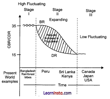
Question 15.
How does the natural increase in population occur, as per the graph? [1]
(a) Birth Rate- Death Rate
(b) Death Rate + Birth Rate
(c) Growth Rate – Birth Rate
(d) Birth Rate + Migration
Answer:
(a) Birth Rate- Death Rate
Explanation: The difference between the birth rate and the death rate of a country or place causes the natural increase.
Question 16.
What does the transition from high fluctuating stage to low fluctuating stage indicate? [1]
(a) Shift from Urban Industrial economy to Rural Agrarian economy
(b) Shift from Rural Agrarian economy to Urban Industrial economy
(c) Low Birth and Death Rate to High Birth and Death Rate
(d) Migration from Urban to Rural areas
Answer:
(b) Shift from Rural Agrarian economy to Urban Industrial economy
Explanation: The transition from the high fluctuating stage to the low fluctuating stage in the demographic transition model indicates a shift from an agrarian-based society with high birth and death rates to an industrialised society with lower birth and death rates. As industrialisation and urbanisation take place, people move from rural areas to urban centers, and non-agricultural sectors become dominant sources of livelihood. This shift reflects economic and social changes during the demographic transition process.
![]()
Question 17.
From the given graph, what condition can you infer about the least developed countries? [1]
(a) High Birth Rate and High Death Rate
(b) Low Birth rate and Low Death rate
(c) High Birth Rate and Low Death Rate
(d) Low Birth Rate and High Death Rate
Answer:
(a) High Birth Rate and High Death Rate
Explanation: Least-developed countries (LDCs) typically face several socio-economic challenges, including high birth rates and high death rates. These countries often have limited access to healthcare, education, and adequate resources, leading to higher mortality rates due to preventable diseases, malnutrition, and lack of medical facilities.
Section-B (2×3=6 Marks)
Source-based questions
Question 18.
Read the given Passage carefully and answer the questions that follow: [3]
Settlements vary in size and type. They range from a hamlet to metropolitan cities. With size, the economic character and social structure of settlements changes and so do its ecology and technology. Settlements could be small and sparsely spaced; they may also be large and closely spaced. The sparsely located small settlements are called villages, specialising in agriculture or other primary activities. On the other hand, there are fewer but larger settlements which are termed as urban settlements specializing in secondary and tertiary activities. The basic differences between rural and urban settlements are as follows:
The rural settlements derive their life support or basic economic needs from land based primary economic activities, whereas, urban settlements, depend on processing of raw materials and manufacturing of finished goods on the one hand and a variety of services on the other.
Cities act as nodes of economic growth, provide goods and services not only to urban dwellers but also to the people of the rural settlements in their hinterlands in return for food and raw materials. This functional relationship between the urban and rural settlements takes place through transport and communication network.
Rural and urban settlements differ in terms of social relationship, attitude and outlook. Rural people are less mobile and therefore, social relations among them are intimate. In urban areas, on the other hand, way of life is complex and fast, and social relations are formal.
(a) On what basis rural and urban settlements can differ from each other?
(b) ‘Towns act as nodes of economic growth.’ How?
(c) Social relationships are more intimate in rural areas in comparison to urban areas. Justify.
Answer:
(a) Rural and urban settlements differ based on size, economic activities, and social structure. Rural areas rely on land-based primary economic activities like agriculture, while urban areas depend on processing of raw materials, manufacturing of finished goods, and a variety of services.
(b) Towns act as nodes of economic growth by providing goods and services not only to urban dwellers but also to rural settlements, creating a functional relationship through transport and communication networks.
(c) Social relationships are more intimate in rural areas due to less mobility, fostering close-knit communities. In contrast, urban areas have a complex and fast-paced lifestyle, leading to more formal social relations.
![]()
Question 19.
Observe the given map and answer the following questions: [3]
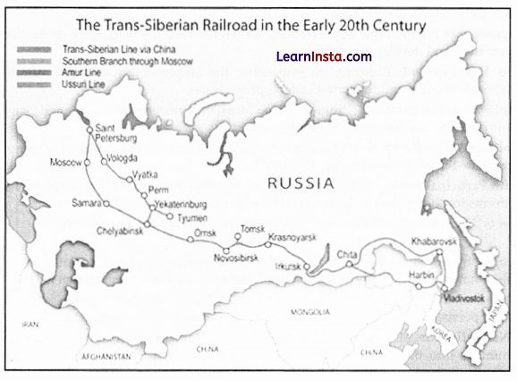
(a) Name the Railway line and the country where it lies.
(b) Name the stations marked as ‘A’ and ‘B’.
(c) State two reasons why it is the most important route in Asia?
Answer:
(a) Trans-Siberian Railway, Russia.
(b) Moscow and Chita
(c) 1. The Trans-Siberian Railway passes through the agro-Centre of Chita and the fur Centres of Irkutsk.
2. It has helped in opening its Asia region to west European markets.
3. Additionally, it connects to Ukraine, Uzbekistan, Mongolia, and China.
Section-C (4×3=12 Marks)
Short Answer type questions
Question 20.
(A) “The basic goal of development is to create conditions where the people can live a meaningful life” – What do you mean by meaningful life? [3]
OR
(B) How do people’s choices get affected in different aspects of life due to lack of human development?
Answer:
(A) A meaningful life, in the context of development, implies a state where individuals enjoy good health, purposeful existence, freedom to pursue their goals, and opportunities to develop their talents, fostering well-being and fulfillment within a just and thriving society.
OR
(B) Due to a lack of human development, people’s choices are significantly impacted in various aspects of life.
1. Limited access to education and healthcare restricts opportunities for personal growth and career advancement.
2. Inadequate economic opportunities can trap individuals in poverty with few chances for improvement.
3. Gender norms and discrimination may limit women’s choices and participation.
4. Insufficient infrastructure and transportation hinder access to essential resources and amenities.
5. Overall, this lack of development perpetuates poverty, inequality, and social challenges, affecting both individual well-being and societal progress.
Question 21.
What are the features of National Youth Policy? [3]
Answer:
Features of the National Youth Policy:
Empowerment: Providing opportunities for youth to actively participate in decision-making, governance, and development processes.
Skill Development: Focusing on enhancing the employability of youth through education, vocational training, and capacity-building programmes.
Employment Generation: Promoting job creation, entrepreneurship, and support for self-employment to address youth
unemployment Health and Well-Being: Ensuring access to healthcare services and addressing mental health issues to promote the overall well-being of youth.
Youth Participation: Involving young people in policy formulation and implementation, creating platforms for their voices to be heard and concerns addressed.
![]()
Question 22.
(A) How is ‘Naturalisation of Humans’ different from ‘Humanisation of Nature’? [3]
OR
(B) ‘Geography got subjected to dualism and the wide-ranging debates started with regard to the subject matter of geography as a discipline.’ Mention any three dualism that exist in Geography.
Answer:
(A) Naturalisation of Humans’ and ‘Humanisation of Nature’ are two different concepts that involve distinct perspectives on the relationship between humans and the natural world.
1. Naturalisation of Humans: ‘Naturalisation of Humans’ refers to the process of integrating humans into the natural environment or allowing human activities to occur in a way that mimics natural processes. It involves harmonising human actions with nature, emphasising sustainability and ecological balance. The focus is on adopting practices that do not harm the natural environment and integrating human societies with the broader ecosystems.
2. Humanisation of Nature: ‘Humanisation of Nature’ refers to the transformation of the natural environment to suit human needs and preferences. It involves modifying and reshaping nature to serve human purposes, often through urbanisation, industrialisation, and extensive resource extraction. The focus is on exploiting and controlling nature to cater to human demands and desires, sometimes leading to environmental degradation and the loss of biodiversity.
OR
(B) The discipline of geography saw extensive debates due to three dualisms:
1. The debate over whether geography should be theoretical and law-making (nomothetic) or descriptive (idiographic).
2. The question of choosing between a regional or systematic approach to study.
3. The dilemma of interpreting geographical phenomena using either theoretical models or historical institutional approaches.
Question 23.
“Quaternary activities centres around research and development.” Examine the statement. [3]
Answer:
The statement accurately emphasises that Quaternary activities are centered around research and development. These activities involve specialised knowledge and technical skills, leading to innovation and advancements in various fields. Consequently, Quaternary activities play a crucial role in driving economic growth and societal progress, contributing significantly to the overall development and competitiveness of a nation in a knowledge-driven global economy.
Section-D (5×5=25 Marks)
Long Answer Type Questions
Question 24.
“There is low yield per acre but high yield per person in the interior parts of semi-arid lands of the mid latitudes in the world.” Support the statement with suitable examples from different parts of the world. [5]
Answer:
The statement is supported by the practice of Extensive Commercial Cultivation in the interior parts of semi-arid lands within the mid-latitudes. These regions, found between 30° to 55° latitude, encompass temperate grasslands and employ extensive farming methods. While the yield per acre may be low but the high yield per person is achieved due to the vast land area and mechanisation.
Examples of Extensive Commercial Cultivation can be observed in various parts of the world, such as:
1. Eurasia: The vast grasslands of Russia and Kazakhstan engage in extensive farming practices, producing significant quantities of wheat and other grains, resulting inhigh yields per person.
2. Canada: The Canadian Prairies utilise extensive commercial cultivation to grow crops like canola and barley, yielding substantial output per person despite lower yields per acre due to the large land area involved.
3. USA: The Great Plains region, extending from Texas to North Dakota, practices extensive agriculture with the cultivation of maize and wheat, ensuring sufficient food production per person.
4. Argentina: The Pampas region of Argentina is a prime example of extensive commercial cultivation, focusing on crops like soybeans, com, and wheat, supporting a high yield per person.
In conclusion, the interior parts of semi-arid lands in the mid-latitudes demonstrate the success of extensive commercial cultivation, which, despite having low yields per acre, effectively ensures high yield per person through the utilisation of vast lands and mechanised agricultural practices.
![]()
Question 25.
Formulate the guidelines to promote sustainability in the Indira Gandhi Canal Command area. [5]
Answer:
Guidelines to promote sustainability in the Indira Gandhi Canal Command area:
1. Efficient Water Management: Implement water-efficient irrigation practices like drip irrigation and sprinkler systems to minimize water wastage and ensure optimal water usage.
2. Water Conservation: Encourage farmers to adopt rainwater harvesting techniques to recharge groundwater and reduce dependency on canal water during the monsoon season.
3. CropDiversification: Promote the cultivation of climate-resilient and water-efficient crops, reducing pressure on water resources and enhancing agricultural sustainability.
4. Soil Health Improvement: Advocate for the use of organic fertilizers, crop rotation, and soil conservation measures to maintain soil fertility and prevent soil erosion.
5. Afforestation and Agroforestry: Encourage tree plantation and agroforestry practices to improve biodiversity, reduce soil erosion, and mitigate the impact of climate change.
6. Awareness and Education: Conduct awareness campaigns and training programs for farmers to enhance their understanding of sustainable agricultural practices and water conservation.
7. Efficient Energy Use: Promote the adoption of renewable energy sources for pumping water and other agricultural activities to reduce carbon footprint and ensure long-term energy sustainability.
8. CommunityParticipation: Involve local communities, farmers, and stakeholders in decision-making processes and the implementation of sustainable practices to foster ownership and commitment.
Question 26.
(A) Land degradation in India is caused by human made processes that are more harmful than natural processes. Explain the statement with suitable examples. [5]
OR
How has noise pollution become a serious problem in recent years in India? Explain.
Answer:
Human-made processes in India, such as deforestation, unsustainable agriculture, industrial pollution, urbanisation, mining, overgrazing, and improper waste disposal, cause more significant land degradation than natural processes.
1. Deforestation disrupts soil stabilisation, while agriculture depletes soil fertility and causes salinisation. Industrial pollution leads to soil contamination, while urbanisation seals land and disrupts drainage.
2. Mining causes habitat destruction and pollution. Overgrazing contributes to soil compaction and erosion.
3. Improper waste disposal contaminates soil and groundwater.
4. Addressing this issue requires sustainable land management and environmental regulations to minimize human impact and preserve the ecosystem for future generations.
OR
In recent years, noise pollution has become a serious problem in India, primarily due to various technological innovations that have resulted in increased urbanisation, industrialisation, and transportation activities. The rapid growth of population and economic development has led to a surge in vehicular traffic, both on roads and at sea harbors, resulting in a significant increase in noise levels.
1. Traffic noise is a major concern in urban areas as it depends on factors like the type of vehicles, road conditions, and traffic density. The proliferation of automobiles, trains, and aircraft in congested cities has intensified noise pollution, leading to health issues and a reduced quality of life for residents.
2. Sea traffic contributes to noise pollution mainly during loading and unloading activities at harbours. The growing shipping trade and higher vessel speeds have increased ocean noise, affecting marine ecosystems and marine life.
3. Industrial activities also contribute to noise pollution, with varying intensities based on the type of industry and its location. Factories and manufacturing units in urban areas generate considerable noise, impacting nearby residential areas.
To address this escalating problem, it is crucial for the government to implement strict noise control regulations, promote public awareness, and encourage the use of quieter and more eco-friendly technologies. Sustainable urban planning, traffic management, and noise reduction strategies are essential to mitigate the adverse effects of noise pollution on the health and well-being of the population and the environment.
![]()
Question 27.
(A) How technological innovations are important aspect of modem manufacturing industries? Explain any five aspects. [5]
OR
(B) “High technology, or simply high-tech, is the latest generation of manufacturing activities”. Justify the statement with suitable arguments.
Answer:
(A) In modem manufacturing, new technologies are essential for several important reasons.
1. First, using complex machines helps to make high-quality products faster.
2. Second, having enough money to investin the latest technology is crucial for better production.
3. Third, when workers specialise in specific tasks and work together, it makes using advanced machines more efficient.
4. Fourth, automation is when machines do most of the work without needing human help, reducing mistakes.
5. Finally, using eco-friendly technologies that helps to protect the environment by reducing pollution.
Research and development in these areas lead to better quality control, less waste, and more progress in manufacturing. These innovations help companies stay competitive and produce goods that satisfy customers’ needs.
OR
(B) High technology, also known as high-tech, represents the latest generation of industries, experiencing rapid growth over the past few decades. It is characterised by the following features:
1. Scientific Research and Development: High-tech industries heavily invest in scientific research and development (R&D) to create highly sophisticated products. This emphasis on innovation drives their competitive edge.
2. Rapid Product Improvement: These industries continuously improve their products to keep up with the ever-growing market demands. The ability to adapt quickly is a hallmark of high-tech manufacturing.
3. Skilled Labour Requirements: Given the complexity of their products, high-tech industries rely on a highly skilled labour force. Workers possess specialised knowledge and expertise in their respective fields.
4. White Collar Workforce: Professional, white-collar workers constitute the main workforce in high-tech industries. Their roles include design, engineering, research, and management.
5. Advanced Technologies: High-tech industries utilize advanced technologies to enhance efficiency and precision. Robotics in assembly lines, computer-aided design (CAD), and electronic controls in refining processes are notable examples.
6. Modem Industrial Landscape: The physical layout of high-tech industries features neatly spaced, low-rise buildings, reflecting a shift away from massive assembly structures and warehouses. Offices, laboratories, and plants are dispersed within the modern industrial landscape.
![]()
Question 28.
(A) What are the advantages of seaports for India? [5]
OR
(B) Why is seaport termed as gateway of international trade?
Answer:
(A) The advantages of seaports for India are as follows:
1. Cost-Effective Transportation: India’s extensive coastline and numerous seaports provide cost-effective transportation options. Water transport is generally cheaper compared to other modes, especially for heavy and bulky goods.
2. International Trade Facilitation: Sea ports serve as crucial gateways for India’s international trade. They enable the import and export of goods, enhancing India’s connectivity with global markets.
3. Indented Coastline and Natural Harbors: India’s indented coastline with natural harbors offers sheltered areas for ports. These features make it easier to establish and maintain port facilities, boosting maritime activities.
4. Promoting Economic Growth: Seaports play a significant role in stimulating economic growth in coastal regions. They generate revenue through port operations, trade activities, and related services, creates employment opportunities and contributes to the overall economy.
5. Suez Canal Impact: The opening of the Suez Canal has further promoted and encouraged seaports along India’s west coast. The canal reduced travel time and distance to Europe, making it an attractive route for trade and facilitating more extensive maritime connectivity.
OR
(B) Seaports are termed as gateways of international trade for several reasons:
1. Resource Suction Points: Seaports act as suction points for resources from their hinterlands. They serve as entry and exit points for various goods, enabling the movement of resources between different regions and countries.
2. Connectivity: Seaports are connected to the interior through railways and roadways, which link local markets to regional markets, regional markets to national markets, and national markets to the international market. This connectivity facilitates the efficient movement of goods to and from the ports.
3. Global Trade Hub: Seaports serve as crucial hubs for global trade, where cargoes and travelers pass from one part of the world to another. They are essential points of transit for international shipments, fostering trade relations between nations.
4. Cargo Handling Facilities: Seaports provide vital facilities for docking, loading, unloading, and storage of cargo. These facilities ensure smooth and efficient handling of goods, making the ports highly effective in facilitating international trade.
5. Gateway to Global Markets: Seaports offer access to global markets, enabling countries to export their products and import essential goods from different parts of the world. They act as gateways that connect national economies to the international marketplace.
Section-E (2×5=10 Marks)
Map-based questions
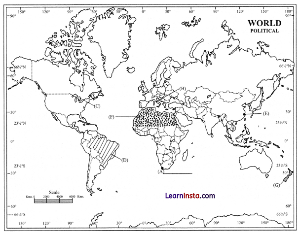
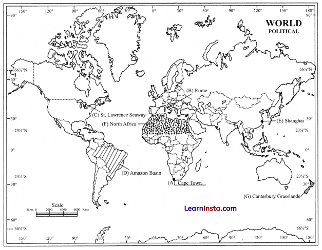
Question 29.
On the given political map of the World, seven geographical features have been marked as A, B, C, D, E, F and G. Identify any five with the help of the following information and write their correct names on the lines drawn near each feature. [5]
a. A major seaport.
b. An international airport.
c. An important Seaway.
d. An area of Subsistence Gathering in South America.
e. An important seaport of Asia.
f. An area of Nomadic Herding.
g. An area of Extensive Commercial Grain Cultivation
Answer:
![]()
Question 30.
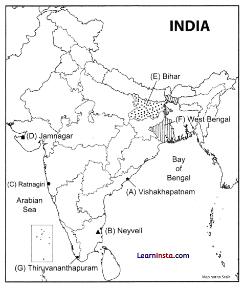
Locate and label any five of the following geographical features on the Political Outline map of India with appropriate symbols: [5]
(a) An important seaport in Andhra Pradesh.
(b) An important coal mine in Tamil Nadu.
(c) Ratnagiri – iron ore mines.
(d) An oil refinery in Gujarat.
(e) The state with highest population density.
(f) The state leading in the production of jute.
(g) An international airport in Kerala.
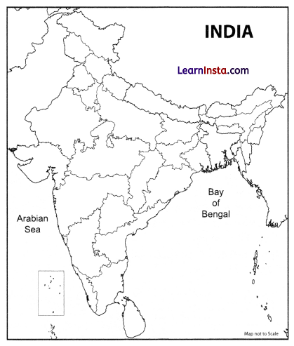
Answer: