Students can access the CBSE Sample Papers for Class 11 Geography with Solutions and marking scheme Set 5 will help students in understanding the difficulty level of the exam.
CBSE Sample Papers for Class 11 Geography Set 5 with Solutions
Time : 3 Hours
Maximum Marks : 70
General Instructions:
- This question paper contains 30 questions. All questions are compulsory.
- This question paper is divided into five sections. Sections-A, B, C, D and E.
- Section A – Question number 1 to 17 are Multiple Choice Type Questions carrying 1 mark each.
- Section B – Question number 18 and 19 are Source Based Questions carrying 3 marks each.
- Section C – Question numbers 20 to 23 are Short Answer Type Questions carrying 3 marks each. Answer to these questions shall be written in 80 to 100 words.
- Section D – Question number 24 to 28 are Long Answer Type Questions carrying 5 marks each. Answer to these questions shall be written in 120 to 150 words.
- Section E – Question number 29 and 30 are Map based questions.
Section – A
Question 1.
There are two statements marked as Assertion (A) and Reason (R). Mark your answer as per the codes provided
below. 1
Assertion: Steep waves are formed by local winds.
Reason: Steep waves are fairly old ones.
Options:
(A) Both (A) and (R) are true but (R) is not the correct explanation of (A)
(B) Both (A) and (R) are true and (R) is the correct explanation of (A)
(C) Both (A) and (R) are incorrect.
(D) (A) is correct but (R) is incorrect.
Answer:
Option (D) is correct.
Explanation: Steep waves are fairly young ones.
Question 2.
Consider the following and choose the correct answer with the help of the given codes: 1
| Column I | Column II |
| i. Cirrostratus | 1. Cloud with extensive vertical development |
| ii. Altocumulus | 2. High cloud |
| iii. Stratocumulus | 3. Low cloud |
| iv. Cumulus | 4. Middle cloud |
Options:
Answer:
Option (C) is correct.
Explanation:
- i. Cirrostratus (2) – Cirrostratus is a high cloud that forms a thin, wispy veil covering the sky.
- ii. Altocumulus (4) – Altocumulus is a middle cloud with a puffy or layered appearance.
- iii. Stratocumulus (3) – Stratocumulus is a low cloud that appears as a low, greyish layer, often with breaks in the clouds.
- iv. Cumulus (1) – Cumulus clouds have extensive vertical development and typically have a fluffy, cotton-like appearance, often associated with fair weather.
Question 3.
The stars are localised lumps of gas within a: 1
(A) nebula
(B) core
(C) gas
(D) hydrogen
Answer:
Option (A) is correct.
Explanation: The stars are localized lumps of gas within a nebula because a nebula is a vast cloud of gas and dust in space where stars form, making it the birthplace of stars in the universe.
Question 4.
Consider the following statements and choose the correct answer with the help of the given options: 1
I. Due to erosion and misuse, the nutritional status goes down and the depth of the soil goes down.
II. The degree of soil degradation remains fixed.
Options:
(A) Both statements are true
(B) Only statement I is true.
(C) Only statement II is true
(D) Both statements are wrong
Answer:
Option (B) is correct.
Explanation: The degree of soil degradation varies from place to place according to topography, wind velocity and amount of rainfall.
Question 5.
Given below is a list of different ecological natural processes and their features, identify which of the following
pair is not correctly matched. 1
| Column I | Column II |
| (A) Species diversity | Hotspots |
| (B) Crop diversity | Agro-diversity |
| (C) IUCN | Red List |
| (D) Wild Life Protection Act | 1973 |
Answer:
Option (D) is correct.
Explanation: The government of India passed the Wild Life Protection Act in 1972 in order to conserve biodiversity.
Question 6.
The only natural satellite of the earth is: 1
(A) moon
(B) sun
(C) planets
(D) galaxy
Answer:
Option (A) is correct.
Explanation: Earth has only one natural satellite which is Moon.
Question 7.
The upper portion of the mantle is called ………………. . 1
(A) Surface rock
(B) Biosphere
(C) Asthenosphere
(D) Lithosphere
Answer:
Option (C) is correct.
Explanation: The upper portion of the mantle is called the asthenosphere.
Question 8.
What is the proportion of area of India which receives annual rainfall less than 75 cm? I
(A) Half
(B) One-third
(C) Two-third
(D) Three-fourth
Answer:
Option (D) is correct.
Explanation: Three-fourth portion of India receives rain-fall less than 75 cm which includes semi-arid and arid regions such as Rajasthan.
Question 9.
Which one of the following phenomena happens when the sun shines vertically over the Tropic of Capricorn in the southern hemisphere? 1
(A) High pressure develops over North-western India due to low temperatures.
(B) Low pressure develops over North-western India due to high temperatures.
(C) No changes in temperature and pressure occur in North-western India.
(D) ‘ Loo’ blows in North-western India.
Answer:
Option (A) is correct.
Explanation: When the sun shines vertically over the Tropic of Capricorn in the southern hemisphere, it leads to high pressure developing over North-western India due to low temperatures, creating a region of relatively cooler air and higher atmospheric pressure.
Question 10.
Consider the following statements and choose the correct answer with the help of the given options: 1
Statement I: Terrestrial ecosystems can further be classified into ‘Homes’.
Statement II: A biome can be defined as a total assemblage of plant and animal species interacting within specific conditions.
(A) Only statement I is correct
(B) Only statement II is correct
(C) Both the statements are correct, and statement II correctly explains statement I
(D) Both the statements are true but not related with each other
Answer:
Option (C) is correct.
Explanation: The boundaries of different biomes on land are determined by climate, therefore, a biome can be defined as total assemblage of plant and animal species interacting within specific conditions.
Question 11.
Arrange the process of soil formation in the correct order: 1
(i) Translocation
(ii) Transformations
(iii) Additions
(iv) Losses
Options:
(A) i, ii, iii, iv
(B) iii, iv, ii, i
(C) ii, iv, iii, i
(D) i, iii, ii, iv
Answer:
Option (B) is correct.
Explanation: Additions (iii) – This is the first step where materials like organic matter, minerals, and nutrients are added to the soil from various sources like decomposing plants, animals, and external factors.
Losses (iv) – Over time, the soil can lose materials through processes like leaching or erosion, leading to a reduction in certain components.
Transformations (ii) – Soil undergoes transformations as minerals and organic matter chemically change and interact with one another due to weathering and microbial activity, altering its composition and properties.
Translocation (i) – Finally, translocation refers to the movement of soil components, such as minerals and nutrients, within the soil profile due to various factors like water and gravity.
Question 12.
The mean monthly temperature throughout the year is over 18°C in: 1
(A) Dry climate
(B) Tropical climate
(C) Rainy climate
(D) Temperate climate
Answer:
Option (B) is correct.
Explanation: The temperature of tropical wet-dry climate regions are high throughout the year.
Question 13.
Movement of water caused by ……………… effects are called surges. 1
(A) meteorological
(B) gravitational
(C) centrifugal
(D) attractional
Answer:
Option (A) is correct.
Explanation: The movement of water caused by meteorological effects due to wind and atmospheric pressure changes are called surges.
Question 14.
The moon’s orbit is closest to the earth: 1
(A) once in a year
(B) once in a month
(C) once in a week
(D) once in a day
Answer:
Option (B) is correct.
Explanation: Once in a month, when the moon’s orbit is closest to the earth unusually high and low tides occur.
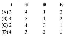
Study the given graph carefully and answer the following question.
Question 15.
According to the graph, the precipitation is highest in which of the following forest zone? 1
(A) Tundra
(B) Desert
(C) Tropical
(D) Steppe
Answer:
Option (C) is correct.
Explanation: Precipitation is higher in the tropical forest zone.
Question 16.
According to the graph, which of the following forest zone has the highest temperature? 1
(A) Taiga
(B) Desert
(C) Tropical
(D) Steppe
Answer:
Option (C) is correct.
Explanation: Highest temperatures are seen in the tropical zone.
Question 17.
Clay mineral zone is found in: 1
(A) Taiga
(B) Savanna
(C) Tundra
(D) Steppe
Answer:
Option (A) is correct.
Explanation: The clay mineral zone is found in Taiga.
Section – B
Question 18 & 19 are Source Based Questions.
Question 18.
Read the given Passage carefully and answer the questions that follow: 3
Physical geography includes the study of the lithosphere (landforms, drainage, relief and physiography), atmosphere (its composition, structure, elements and controls of weather and climate; temperature, pressure, winds, precipitation, climatic types, etc.), hydrosphere (oceans, seas, lakes and associated features with water realm) and biosphere (life forms including human beings and macro-organisms and their sustaining mechanism, viz. food chain, ecological parameters and ecological balance). Soils are formed through the process of pedogenesis and depend upon the parent rocks, climate, biological activity, and time. Time provides maturity to soils and helps in the development of soil profiles. Each element is important for human beings.
Landforms provide the base on which human activities are located. The plains are utilized for agriculture. Plateaus provide forests and minerals. Mountains provide pastures, forests, and tourist spots and are sources of rivers providing water to lowlands. Climate influences our house types, clothing, and food habits. The climate has a profound effect on vegetation, cropping patterns, livestock farming some industries, etc. Human beings have developed technologies that modify climatic elements in a restricted space such as air conditioners and coolers. Temperature and precipitation ensure the density of forests and the quality of grasslands. In India, monsoonal rainfall sets the agriculture rhythm in motion. Precipitation recharges the groundwater aquifers, which later provide water for agriculture and domestic use.
a. What ensures the density of forests and quality of grasslands?
b. What has a profound effect on vegetation cropping patterns, livestock farming, and some industries?
c. What recharges the ground aquifers, which later provides water for agriculture and domestic use?
Answer:
a. Temperature and precipitation.
b. Climate affects vegetation, cropping patterns, livestock farming, and some industries.
c. Precipitation helps to recharge the ground aquifers.
Question 19.
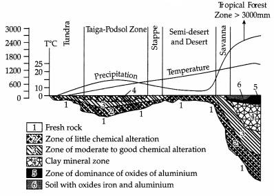
Observe the below-given world map and answer the following.
a. What is the above map representing?
b. Recognise any one continent that is marked with ‘H’.
c. What does the letter ‘H’ mean here?
Answer:
a. Distribution of pressure
b. Australia has high pressure according to the map.
c. H- represents high-pressure area
Section – C
Question numbers 20 to 23 are Short Answer Type Questions.
Question 20.
Geography being a scientific discipline, what do you think how many categories of questions is geography concerned with? Explain. 3
OR
What are the sub-branches of Physical Geography? Explain in detail any three sub-branches.
Answer:
Geography as a scientific discipline is concerned with three sets of questions:
- Some of the questions are related to the identification of the various patterns of natural and cultural features as found over the surface of the Earth. These are the questions about ‘what’?
- The second kind of question is related to the distribution of the natural and human/cultural features over the surface of the Earth. These are the questions about ‘where’?
- The third kind of question is related to the explanation or the casual relationships between features and the processes and phenomena. This aspect of geography is related to the question ‘why’.
OR
The sub-branches of Physical Geography are:
- Geomorphology: It is devoted to the study of landforms, their evolution and related processes.
- Climatology: It encompasses the study of the structure of the atmosphere and elements of weather and climates and climatic types and regions.
- Hydrology: It studies the realm of water over the surface of the earth including oceans, lakes, rivers and other water bodies and its effect on different life forms including human life and their activities.
- Soil Geography: It is devoted to the study of the processes of soil formation, soil types, their fertility status, distribution and use.
Question 21.
Describe the characteristics of waves. 3
Answer:
The various characteristics of waves are:
- Wave crest and trough: The highest and lowest points of a wave are called the crest and trough respectively.
- Wave height: It is the vertical distance from the bottom of a trough to the top of a crest of a wave.
- Wave amplitude: It is one-half of the wave height.
- Wave period: It is merely the time interval between two successive wave crests or troughs as they pass a fixed point.
- Wavelength: It is the horizontal distance between two successive crests.
- Wave speed: It is the rate at which the wave moves through the water and is measured in knots.
- Wave frequency: It is the number of waves passing a given point during a one-second time interval.
Question 22.
What do you know about River Tapi? 3
OR
Name any three factors that affect the speed of a river.
Answer:
The Tapi is the other important westward-flowing river. It originates from Multai in the Betul district of Madhya Pradesh. It is 724 km long and drains an area of 65,145 sq. km. Nearly 79 per cent of its basin lies in Maharashtra, 15 per cent in Madhya Pradesh and the remaining 6 per cent in Gujarat.
OR
Factors affecting the speed of a river:
(i) Gradient: If refer to the drop in the elevation of the river channel as the river flows down the hill. If the gradient is steep, the rivers flow quickly, whereas, if the gradient is gentle the river flows slowly. In the upper course, the river flows rapidly through a steep gradient. On the other hand, in the middle and the lower course, the river flows gently through a greater gradient.
(ii) Speed: around the perimeter of the river, at the sides and along the river bed friction is created as water flows against the edges. Water flowing through a wide, deep river channel encounters less resistance than water flowing in a narrow, shallow channel.
(iii) Volume of water: The volume of water that flows through a river within a given amount of time known as the discharge-also affects its velocity. As the volume of water in a river increase, through smaller streams flowing into it, for example, the velocity of the river increases. An increase in water volume can also affect a river’s velocity in the long term.
Question 23.
What do you know about Biodiversity? 3
Answer:
Biodiversity is a system in constant evolution, from the viewpoint of species, as well as from the viewpoint of an individual organism. The average half-life of a species is estimated at between one and four million years and 99 per cent of the species that have ever lived on the earth are today extinct. Biodiversity is not found evenly on the earth. It is consistently richer in the tropics. As one approaches the polar regions, one finds larger and larger populations of fewer and fewer species. Biodiversity is our living wealth. It is a result of hundreds of millions of years of evolutionary history.
Section – D
Question numbers 24 to 28 are Long Answer Type Questions.
Question 24.
What are the different types of mass movements? 5
Answer:
The different types of mass movements are:
(i) Slow Movements: Creep is one type under this category that can occur on moderately steep soil-covered slopes. The movement of materials is extremely slow and imperceptible except through extended observation. Materials involved can be soil or rock debris. Depending upon the type of material involved, several types of creep viz., soil creep, talus creep, rock creep, rock-glacier creep, etc., can be identified.
(ii) Rapid Movements: These movements are mostly prevalent in humid climatic regions and occur over gentle to steep slopes. The movement of water-saturated clayey or silty earth materials down low-angle terraces or hillsides is known as earth-flow. Quite often the materials slump making step like terraces and leaving arcuate scarps at their heads and an accumulation bulge at the toe. When slopes are steeper, even the bedrock especially of soft sedimentary rocks like shale or deeply weathered igneous rock may slide down-slope.
(iii) Landslides: These are known as relatively rapid and perceptible movements. The materials involved are relatively dry. The size and shape of the detached mass depends on the nature of discontinuities in the rock, the degree of weathering and the steepness of the slope. Landslides are of four types:
(a) Slumps
(b) Debris slide
(c) Rockslide
(d) Rockfall: It is the free falling of rock blocks over any steep slope keeping itself away from the slope.
Question 25.
Discuss the processes through which the earth’s atmosphere system maintains heat balance. 5
Answer:
The earth receives most of its energy in the form of short waves of radiation from the sun. All the solar energy entering the earth-atmosphere system is radiated back to the space maintaining the temperature of the earth-atmosphere system.
(i) A variety of processes – absorption, scattering, diffusion, reflection, terrestrial radiation, etc., make this possible.
(ii) Out of the total incoming solar radiation entering the earth’s atmosphere, 35 per cent is sent back to space through scattering by dust particles, reflection from the clouds and from the ground surface. The 51 per cent of solar energy received by the earth comprises 34 per cent as direct solar radiation and 17 per cent as diffuse daylight. The earth after being heated by insolation transmits the heat to the atmospheric layers near to the earth in the long waveform. The air in contact with the land gets heated slowly and the upper layers in contact with the lower layers also get heated.
(iii) The earth after being heated itself becomes a radiating body and it radiates energy to the atmosphere in long waveforms. This energy heats up the atmosphere from below, a process called terrestrial radiation. The transfer of heat continues until both bodies attain the same temperature or the contact is broken. Conduction is important in heating the lower layers of the atmosphere.
(iv) The long waves of radiation are absorbed by atmospheric gases, particularly by carbon dioxide and other greenhouse gases. Thus, the atmosphere is indirectly heated by the Earth’s radiation. The air in contact with the earth rises vertically on heating in the form of currents and further transmits the heat of the atmosphere.
(v) The atmosphere in turn radiates and transits heat to the space. Finally, the amount of heat received from the sun is returned to space, thereby maintaining the heat balance of the earth-atmosphere system.
Question 26.
Bring about the basic difference between the Drift theory and Plate tectonics 5
OR
What were the major post-drift discoveries that rejuvenated the interest of scientists in the study of the distribution of oceans and continents?
Answer:
| S.no | Drift Theory | Plate tectonics |
| 1. | This theory was put forth by German meteorologist Alfred Wegener. | This theory was put forth by McKenzie and Parker. |
| 2. | According to this theory, all continents formed a single continental mass called Pangaea. | According to this theory, the earth’s lithosphere is divided into 7 major and some minor plates. |
| 3. | Wegener argued that around 200 million years ago the supercontinent, Pangaea, began to split. | A tectonic plate is also called a lithospheric plate. |
| 4. | Pangaea first broke into two large continental masses as Laurasia and Gondwana land forming Northern and Southern components respectively. | The plates move horizontally over the asthenosphere as rigid units. |
| 5. | Laurasia and Gondwana land continue to break into various smaller continents that exist today. | Pacific plate is largely an oceanic plate whereas the Eurasian plate may be called a continental plate. |
OR
A number of discoveries during the post-war period added new information to geological literature. Particularly, the information collected from the ocean floor mapping provided new dimensions for the study of the distribution of oceans and continents.
(i) Currents are generated due to radioactive elements causing thermal differences in the mantle portion. Holmes argued that there exists a system of such currents in the entire mantle portion. This was an attempt to provide an explanation for the issue of force, on the basis of which contemporary scientists discarded the continental drift theory.
(ii) Detailed research of the ocean configuration revealed that the ocean floor is not just a vast plain but it is full of relief.
(iii) Expeditions to map the oceanic floor in the post-war period provided a detailed picture of the ocean relief and indicated the existence of submerged mountain ranges as well as deep trenches, mostly located closer to the continent margins.
(iv) The mid-oceanic ridges were found to be most 27. There are several warm ocean currents that move active in terms of volcanic eruptions. The dating warm water away from the equator. These currents of the rocks from the oceanic crust revealed the fact that the latter is much younger than the continental areas.
(v) Rocks on either side of the crest of oceanic ridges and having equidistant locations from the crest were found to have remarkable similarities both in terms of their constituents and their age.
Question 27.
Why are some currents warm or cold? 5
OR
What are the causes of currents?
Answer:
There are several warm ocean currents that move warm water away from the equator. These currents of water have warm air above the water. The warm air raises the temperature of the land it touches. These areas enjoy a much warmer climate than other places at the same latitude. Areas such as England would be much colder without the warm Gulf Stream. Warm ocean currents flow on the eastern side of the continent.
They only reach the western side in high-latitude areas. Another characteristic is that they flow away from the equator. Warm currents have higher temperatures, so they are less dense than cold water. Usually, warm water has a higher salinity, but it remains less dense than cold water, so cold water is heavier and flows under warm water. The water is warmed on the surface, so warm currents flow across the surface of the ocean. As the warm current cools down, it drops down and becomes a cold water current.
OR
Ocean currents are like river flow in oceans. They represent a regular volume of water in a definite path and direction. Ocean currents are influenced by two types of forces namely:
(i) Primary forces that initiate the movement of water.
(ii) Secondary forces that influence the currents to flow. Primary Forces: The primary forces that influence the currents are:
(a) Heating by solar energy: Heating by solar energy causes the water to expand. That is why, near the equator the ocean water is about 8 cm higher in level than in the middle latitudes. This causes a very slight gradient and water tends to flow down the slope.
(b) Wind: Wind blowing on the surface of the ocean pushes the water to move. Friction between the wind and the water surface affects the movement of the water body in its course.
(c) Gravity: Gravity tends to pull the water down the pile and create gradient variation.
(d) Coriolis force: The coriolis force intervenes and causes the water to move to the right in the northern hemisphere and to the left in the southern hemisphere. These large accumulations of water and the flow around them are called Gyres. These produce large circular currents in all the ocean basins.
Question 28.
Forest and tribals are very closely related.’ Justify the statement. 5
OR
Explain the characteristics of the global distribution of rainfall.
Answer:
To a vast number of tribal people, the forest is a home, a livelihood, and their very existence. It provides them with food, fruits of all kinds, edible leaves, honey, nourishing roots and wild game. It provides them with materials to build their houses and items for practising their arts. The importance of forests in the tribal economy is well-known as they are the source of sustenance and livelihood for tribal communities. It is commonly believed that the tribal communities live in harmony with nature and protect forests. Out of a total of 593 districts, 187 (2001) have been identified as tribal districts.
The tribal districts account for about 59.8 per cent of the total forest cover of the country whereas the geographical area of 187 tribal districts forms only 33.6 per cent of the total geographical area of the country. It demonstrates that tribal districts are generally rich in forest cover. Forest and tribals are very closely related. The age-old knowledge of tribals regarding forestry can be used in the development of forests. Rather than treating tribals as minor forest produce collectors they should be made growers of minor forest produce and encouraged to participate in conservation.
OR
Different places on the earth’s surface receive different amounts of rainfall in a year and that too in different seasons. Generally, rainfall decreases from the equator towards the poles. The coastal areas of the world receive more rainfall compared to the interior of the continents. The rainfall is more over the oceans as compared to the land because of the sources of water. Between the 35° and 40° N and S latitudes of the equator, the rain is heavier on the eastern coasts and goes on decreasing towards the west.
But, between 45° and 65° N and S of the equator, due to the westerlies, the rainfall is more on the western margins of the continents and it goes on decreasing towards the east. If mountain ranges are located parallel to the coast, the rain is greater on the coastal plain, on the windward side and it decreases towards the leeward side. The equatorial belt, the windward slopes of the mountains along the western coasts and the coastal areas of the monsoon land receive heavy rainfall. Interior continental areas receive moderate rainfall varying from 100 – 200 cm per annum. Areas lying in the rain shadow zone of the interior of the continents and higher latitudes receive very low rainfall. In some regions, rainfall is distributed evenly throughout the year such as: equatorial belt and in the western parts of cool temperate regions.
Section – E
Question numbers 29 & 30 are Map based questions having 5 sub-parts each.
Question 29.
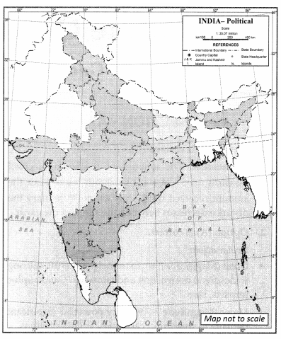
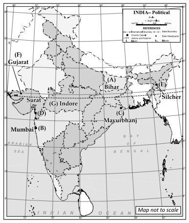
Identify and mark any five of the following features on the Political Outline map of India with the_help of the given information: 5
(A) State with high level of population density
(B) A city with more than 10 million population in Maharashtra state
(C) An iron-ore mine in Odisha state
(D) A centre of cotton textile in Gujarat state
(E) An important node on east-west corridor in Assam state
(F) Leading state of cotton production
(G) Software technology park in Madhya Pradesh
Answer:
Question 30.
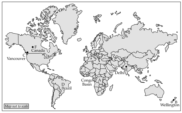
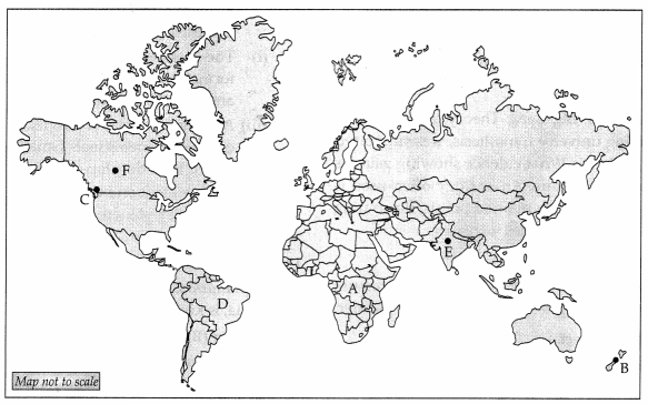
Below given are some of the major geographical features of the world. Locate and mark them based on the given information in the outline map of the World. Locate any five of the following. 5
(A) An area of subsistence gathering
(B) A major international airport
(C) A terminal station of the Trans-Canadian Railway
(D) The largest country in South America
(E) A mega city
Answer: