These Class 6 Social Science Worksheet and Class 6 SST Chapter 1 Locating Places on the Earth Worksheet with Answers are excellent for board exam practice.
Class 6 SST Chapter 1 Locating Places on the Earth Worksheet
Class 6 Locating Places on the Earth Worksheet
Worksheet On Locating Places on the Earth Class 6 – Locating Places on the Earth Worksheet Class 6
Multiple choice questions (MCQs)
Question 1.
What is the main purpose of a map?
(a) To predict weather
(b) To show directions and locations
(c) To display advertisements
(d) To measure time
Question 2.
Which of the following is not a component of a map?
(a) Distance
(b) Direction
(c) Symbols
(d) Volume
Question 3.
What do the blue areas on a map typically represent?
(a) Forests
(b) Water bodies
(c) Mountains
(d) Roads
Question 4.
Which of the following is an example of an intermediate direction?
(a) North
(b) Southeast
(c) West
(d) East
Question 5.
What is the function of a compass rose on a map?
(a) It shows elevation
(b) It indicates the scale
(c) It shows cardinal directions
(d) It marks landmarks
![]()
Question 6.
A thematic map is used to:
(a) Show general geographic features
(b) Display political boundaries
(c) Focus on specific information like climate or population
(d) Show topographical details
Question 7.
What do we call a person who makes maps?
(a) Geologist
(b) Astronomer
(c) Cartographer
(d) Navigator
Question 8.
What will be the correct colour symbol for—Buildings and settlements, Mountains or heights, Vegetation, Roads, railways and other man-made structures?
(a) Red, Brown, Green, Black
(b) Brown, Red, Black, Green
(c) Green, Brwon, Blue, Red
(d) Black, Brown, Red, Green
Fill in the blanks
1. The globe is __________ but the map is __________
2. An __________ is a collection of maps.
3. Three main components of a map are __________, __________ and __________
4. Only __________ direction is indicated on a map.
5. The __________ defines, how big or small the map is.
6. Some __________ are used for same object since long time by most of the people, so they have developed a convention.
7. The equator and the Prime Meridian cut each other at __________ angle.
8. __________ are used to determine the location of any map.
9. The Earth moves from the __________ to __________ direction.
10. Ancient Indian Prime Meridian was passing through __________
Do it yourself
Keep a round protector and a table clock together. Look at the four cardinal and rest four intermediate directions. Now compare them and write the angle of each direction, like one is given for you.
- North 180°
- West __________
- Southeast __________
- Southwest __________
- East __________
- South __________
- North East __________
- Northwest __________
Let’s find
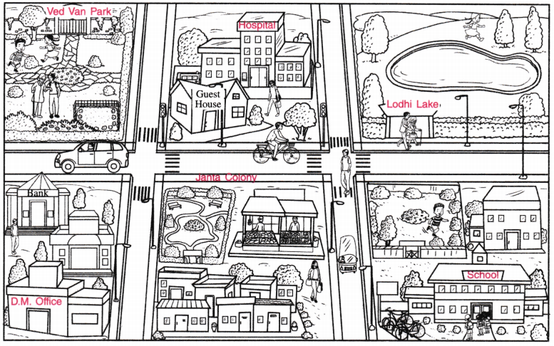
Look at the sketch given, draw an arrow and write the direction of each place as per the instruction. One is given for you.
1. of Bank from DM office ↑North
2. of School from Lodhi lake __________
3. of Janta Colony from Lodhi lake __________
4. of Hospital from Bank __________
5. of Vegetable vendor of Janta Colony from Ved Van Park __________
6. of Hospital from Ved Van Park __________
7. of Ved Van Park from the School __________
8. of DM office from the School __________
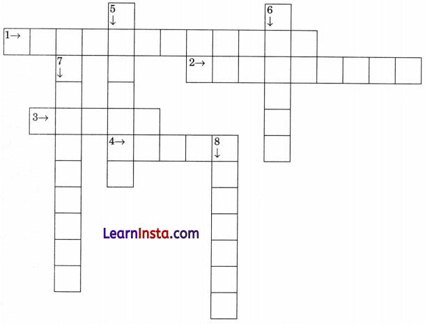
Crossword Puzzle
| Across | Down |
| 1. A person who makes maps. | 5. An instrument used for finding directions. |
| 2. Imaginary lines running from the North Pole to the South Pole. | 6. The part of the map that explains symbols and their meanings. |
| 3. A collection of maps. | 7. Imaginary lines running parallel to the Equator. |
| 4. The ratio of a distance on the map to the corresponding distance on the ground | 8. Largest latitude that divides the earth into two equals of north and south. |
Assertion Reason-based Questions
Choose the correct option after analysing both the statements of assertion and reason.
(a) Both assertion and reason are correct, and reason is the correct explanation for the assertion.
(b) Both assertion and reason are correct, but reason is not the correct explanation for the assertion.
(c) The assertion is correct, but the reason is incorrect.
(d) The assertion is incorrect, but the reason is correct.
1. Assertion: The scale is essential for any map.
Reason: The scale helps determine the accurate size and distance on a map.
2. Assertion: A political map depicts geographical features like rivers and mountains. Reason: Political maps focus on the type and nature of the governing body of that nation.
State whether the statement is true or false
1. Equator is not a great circle. __________
2. All longitudes are full circle. __________
3. All longitudes are equidistant. __________
4. Latitudes never touch or cross each other. __________
5. Longitudes look like radial lines originating from the poles. __________
6. Longitudes and latitudes cut each other at rectangle. __________
7. Distance between two latitudes decreases as we move towards poles __________
Give reason for
Question 1.
Why is the globe a true representation of the Earth but not a map?
_________________________________________
Question 2.
Why our ancestors wanted to create a map?
_________________________________________
Question 3.
Why are maps more popular than the globe?
_________________________________________
Question 4.
Why do any drawing cannot be called a map?
_________________________________________
![]()
Do as directed
Question 1.
Tick the countries that share same time zone of +5 hr 30 min from GMT like Indi(a)
(a) Pakistan
(b) Burma
(c) Nepal
(d) Afghanistan
(e) Bangladesh
(f) Sri Lanka
(g) Bhutan
(h) Tibet
Question 2.
Complete the following.
(a) For preparing birth chart/horoscope which time is used __________.
(b) For calculating date of a place, its time is calculated with reference to __________.
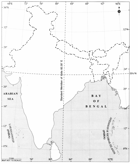
(c) No matter how many time zones India has but __________ is calculated at 82½ °E longitude.
(d) __________ is the opposite side of the Greenwich line which determine date.
Application-based questions
Question 1.
If you were given a map with a scale of 1 cm = 100 km, and you measure 5 cm between two cities on the map, what is the actual distance between these cities?
_________________________________________
_________________________________________
_________________________________________
_________________________________________
Question 2.
Imagine you are at a railway station in a new city. The map shows your hotel to the southeast. How would you orient yourself using a compass to find the correct direction?
_________________________________________
_________________________________________
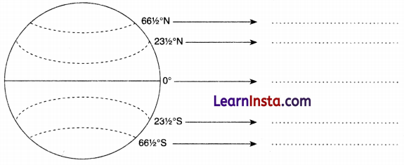
Picture based question
Question 1.
Identify the latitudes.
Question 2.
Calculate the time at these places if GMT is 4 a.m.
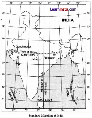
A. Kandla
B. Gandhinagar
C. Jabalpur
D. Bilaspur
E. Ranchi
F. Aizawl
Map based question
If 82½° E is the Prime Meridian of India and its time difference from GMT is 5 hr 30 min then draw the longitude lines on the map with their values to mark + 1 hour and -1 hour N. longitudes from the 1ST.