Students can keep Exploring Society India and Beyond Class 7 Solutions and Class 7 Social Science SST Chapter 1 Geographical Diversity of India Question Answer NCERT Solutions handy for quick reference during exams.
Class 7 Social Science Chapter 1 Question Answer Geographical Diversity of India
NCERT Class 7 Social Science Chapter 1 Geographical Diversity of India Questions and Answers Solutions
Geographical Diversity of India Class 7 Question Answer (In-Text)
The Big Questions? (Page 1)
Question 1.
What are some key geographical features of India?
Answer:
Key geographical features of India are as follows:
- The Himalayas
- The Gangetic Plains
- The Great Indian Desert (Thar Desert)
- The Peninsular Plateau
- India’s Amazing Coastlines
- Indian Islands
Question 2.
How does India’s geographical diversity affect our lives?
Answer:
India’s geographical diversity has a great impact on its climate, farming, cultural practices and lifestyle which affects our lives in certain ways. The Himalayas influence weather and keeps the Indian peninsula warm by blocking cold wind from Central Asia. The fertile Gangetic plains support agriculture and the coasts offer resources like minerals and fish. It plays crucial role in industrial water supply. People shape their customs, occupations and living standards according to geographical features of their regions.
Let’s Explore
Question 1.
Look at the map of India. What are you able to observe? Recall your lesson on different types of landforms – mountains, plains and plateaus. Which landforms can you identify on the map? What do the different colours on the map mean? (Page 2)
(Hint: The legend on the map shows the heights of each area.)
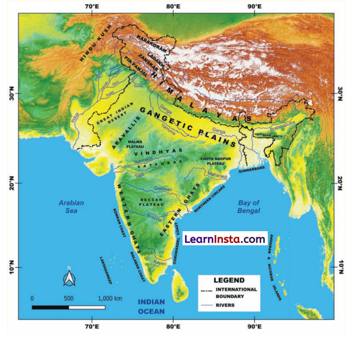
Answer:
The following landforms on the map can be identified.
- The Himalayas
- The Gangetic Plains
- Great Indian Desert
- Aravalli Range
- Western Ghats
- Eastern Ghats
- Deccan Plateau
- Arabian Sea
- Bay of Bengal
Colours
- Brown
- Blue
- Green
- Yellow/light brown
Features
- Mountains
- Oceans/Water bodies
- Plains
- Plateaus / desert
![]()
Question 2.
Do you recall your lesson on latitudes and longitudes? Look at the map. Can you read, approximately, the latitude and longitude where India lies? (Page 3)
Answer:
India is located in the Northern Hemisphere, between 8°4′ N (South most point of India) and 37°6′ N (North most point of India) latitude and in the Eastern Hemisphere it is between 68°7′ (Western most part of India) and 97°25′ (Eastern most point of India) east longitude.
Identify the above features on India’s physical map. (Page 3)
Answer:
Do it yourself.
Hint: Try to find out Geographical features of India such as The Himalayas, Gangetic Plains, Peninsular Plateau, Eastern Coast, Western Coast etc.
Question 3.
Can you locate the names of the states in the different parts of the Himalayas? Take the help of both the physical and political maps for this exercise. (page 6)
Answer:
- In the western part, of Himalayas, the states are Jammu and Kashmir, Himachal Pradesh and Uttarakhand.
- In the eastern part the states are West Bengal, Sikkim and then the north
eastern states – Arunachal Pradesh, Nagaland, Manipur, Mizoram, Tripura, Meghalaya and Assam.
Question 4.
Notice the concentration of lighting in the plains. What could be the reason for this concentration? (page 11)
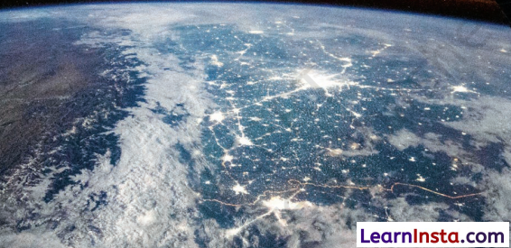
Answer:
The concentration of lighting is a strong indicator of high population density and human activity. Following are the possible reasons for these lightings –
- Fertile Land and Agriculture: The Gangetic Plains are ideal for agriculture, supporting a large population. The lights represent numerous villages and agricultural settlements.
- Dense Population Centres: Development of major cities and towns along the Gangetic Plains are hubs of residential, commercial and industrial activity. All of these significantly contribute to nighttime lighting.
- Infrastructure and Development: Infrastructure and Development including roads, railways and industries require lighting for safety operations, that is why areas appear bright in satellite image.
- Economic Activity: The fertileland supports a strong and healthy agricultural economy. Dense population provides large labour force and consumer market fostering various industries and businesses. These activities often operate in night which require lights.
- Bright lights in the satellite image are visual representation of densely populated and economically active region.
Question 5.
What is the shape of a sand dune? While mountains are made of rock and their shape is fixed, why do you think sand dunes also have a similar shape, even though they are made of sand. (Page 12)
Answer:
Sand dunes have different shapes, influenced by wind speed and direction. The most common dune shape is crescentic. Dunes are made of loose sand still have shapes like mountains because wind deposits sand on a flat surface and this process goes on and on. Over time, the area transforms in an elevated land form holding the rise of approximately 150 metres.
Question 6.
Let’s go back to the map. Trace your path slowly from the Thar Desert towards the east. Do you see the Araxtalli Hills? (Page 14)
Answer:
Do it yourself on the physical map of India.
Question 7.
Look at the political map in the textbook and identify the states that the range spans. Did you see Delhi, Rajasthan, Haryana and Gujarat? (Page 15)
Answer:
Yes, we can see that the Aravalli Ranges span in Delhi, Rajasthan, Haryana and Gujarat.
Question 8.
Look at the physical map of India given at the end of the book (You can also see on page 7 of this book). Notice the direction of the flow of the rivers. (Page 16)
Answer:
Five main rivers in the north, the Jhelum, the Chenab, the Ravi, the Sutlej and the Beas merge into the Indus river and flows out in Arabian Sea. The Yamuna river merges into the Ganga river and flows out in the Bay of Bengal. Rivers like the Godavari, the Krishna and the Kaveri flow across the plateau from west to east and fall into the Bay of Bengal. The Narmada and the Tapti rivers flow from east to west and fall into the Arabian sea
Question 9.
Look at the physical map of India in your school atlas or wall map and find the names of five rivers that flow into the Bay of Bengal. Find out India’s coastal states and discuss the difference between the western and eastern coastal plains. (Page 19)
Answer:
Five rivers that flow into the Bay of Bengal are the Mahanadi, the Godavari, the Krishna, the Kaveri and the Ganges.
- India’s states on western coast are Gujarat, Maharashtra, Goa, Karnataka and Kerala.
- India’s states on eastern coast are West Bengal, Odisha, Andhra Pradesh and Tamil Nadu.
Difference between the western and eastern coastal plains.
| Western Coastal Plains | Eastern Coastal Plains |
| 1. Western coastal plains lies between the Western Ghats and the Arabian Sea. | 1. Eastern coastal plains lies between the Eastern Ghats and the Bay of Bengal. |
| 2. It stretches from Gujarat to Kerala, passing through Maharashtra, Goa and Karnataka. | 2. It stretches from the Ganga Delta to Kanyakumari passing through West Bengal, Odisha, Andhra Pradesh and Tamil Nadu. |
| 3. These plains are shaped by alluvial deposits from small rivers. | 3. Rivers flowing in the eastern coastal plains form delta. |
| 4. Rivers flowing in the western coastal plains form estuaries. | 4. Rivers the Godavari, the Krishna, the Kaveri and the Mahanadi form fertile deltas, making these plains ideal for farming. |
| 5. The Narmada and the Tapti rivers form the largest estuaries. | 5. Chilika lake in Odisha is the largest brackish (Salty water) water lagoon in Asia. |
Question 10.
Do you know what it is called when these rivers split into multiple streams near the coast? Discuss with your teacher in class to find out! (Page 19)
Answer:
Yes, when a river splits into multiple streams near the coast, it is known as a river delta.
The Ganga river forms a huge delta before emptying into the Bay of Bengal. Famous UNESCO heritage site Sundarbans (home to Royal Bengal Tigers) are located in this Ganga delta.
Let’s Remember
Question 1.
The Himalayas seem to touch the sky. In fact many of its peaks are over 8000 meters in height and are together called the ‘Eight Thousanders’. This mountain range stretches across six countries in Asia: India, Nepal, Bhutan, China, Pakistan and Afghanistan. Can you name the highest mountain in the world? (Page 4)
Answer:
The highest mountain in the world is the Mount Everest, which has a height of 8848 meters or 29,032 feet.
Don’t miss out
Question 1.
Most rivers are named after goddesses – Ganga, Yamuna, Kaveri etc. The name of Brahmaputra, however, means ‘the son of Brahma’. This river gets bigger during summer instead of drying up ! Can you guess why? (Page 11)
Answer:
Brahmaputra is a continuous running river, as it is filled by melting snow from the glaciers of the Himalayas. It gets bigger during summer, as more snow melts, more the river swells. It is not a rainfed river, which can diy up in the summer season.
![]()
Class 7 SST Chapter 1 Geographical Diversity of India Question Answer (Exercise)
Questions and Activities (Page 24-25)
Question 1.
What, in your opinion, are two important geographical features of India? Why do you think they are important?
Answer:
In my opinion, two important geographical features are the Himalayas and the Gangetic plains. The reasons are as follows:
- The Himalayan mountains range stands as a natural barrier in the north and protect us from the unbearable cold winds coming from the Central Asia. In this way, it keeps the climate suitable for the people of India.
- In the summer, snow on mountains melts and feed major rivers such as the Ganga, the Yamuna, and the Brahmaputra and provide water for various purposes to the large population. Hence, the Himalayas are called the Water Tower of Asia’.
- The Gangetic Plains: These plains are nourished by rivers such as the Ganga, the Yamuna and the Brahmaputra providing a vital lifeline.
- These rivers make the plains highly fertile and ideal for agriculture and make our country self reliant in food production.
- These plains facilitated development of an elaborate transportation network, alongwith. infrastructural and industrial development.
Question 2.
What do you think India might have looked like if the Himalayas did not exist? Write a short note or sketch a drawing to express your imagination.
Answer:
- If the Himalayas did not exist, we would have to face harsh cold winds, making the whole country much colder.
- Our rivers would not be able provide vital lifeline as there would be no snow covered mountains.
- The Gangetic plains would not be as fertile and basic staple crops such as wheat and rice would not grow easily affecting the food supply for the people.
- We would not have the beautiful hill stations. Our tourism industry would have also suffered.
Our country’s climate would become much drier and colder.
Question 3.
India has been called a ‘minicontinent’. Based on what you’ve read, why do you think this is so?
Answer:
- India has the great Himalayan mountain range standing as a natural barrier in the north and the Thar desert and the Arabian sea guard its western boundaries.
- India has a vast coast line. To the south, the Indian Ocean and to the east the Bay of Bengal make a remarkable natural boundary.
- These geographical features create a difference between India and the rest of the continents.
- It seems like a whole continent, is wrapped into one country.
- Its diverse geography leads to a variety of climate, plants, animals and people.
- India has 28 states having different languages and culture, which also makes it a ‘mini continent’.
Question 4.
Follow one of India’s big rivers from where it starts to where it meets the ocean. What are the different ways in which people might utilise this river along its journey? Discuss in groups in your class.
Answer:
The Ganga is a mighty river which starts from the Gangotri glacier in Uttarakhand and flows all the way to the Bay of Bengal in West Bengal. It is incredibly important for people. People worship it as a Goddess, use its water for drinking, household chores, irrigation, electricity generation, fishing and transportation and for river rafting and other creative activities.
Question 5.
Why is the southern part of India referred to as a peninsular plateau?
Answer:
Southern part of India is a very old land formation.
It is one of the most important triangular plateau in the centre and south region of the country.
This region is surrounded by water on all the three sides by the Arabian sea in the west, the Bay of Bengal in the east and the Indian Ocean in the south. Therefore, it is called a peninsular plateau.
Question 6.
Which UNESCO Heritage Site mentioned in this chapter did you find more interesting? Write a short paragraph to describe what about it is interesting.
Answer:
In my opinion, the Western Ghats are more interesting than the others.
Western Ghats are taller and run along the western coast like a wall. They have many beautiful waterfalls, which flow down their steep slopes during the monsoon season. These Ghats are home to many rivers and have rich biodiversity. Many species of flora and fauna found here are not found anywhere else on the earth. The Western Ghats play a significant role in influencing India’s weather, particularly the monsoon rains which are essential for agriculture. This region is known for its stunning natural beauty and ecological importance.
Question 7.
Look at the two maps of India, physical as well as political, given at the end of this book. Identify the place you are at now. Which physical feature of India would you use to describe its location?
Answer:
We are in Delhi. After examining physical and political map of India, we concluded that the Gangetic plains can be used to describe its locations. (The river Ganga originates from Gaumukh, the Gangotri Glacier’s terminal, in the Himalayas.) It is sacred river for Hindus. This is a flat and fertile land. River Yamuna, a major tributary of the Ganga river, flows in this region. Delhi’s location has made it a center of trade and cultural exchange for centuries. Delhi lies in the south-east of Haryana and in west of Uttar Pradesh.
Question 8.
Food preservation techniques differ from place to place across India. They are adapted to local conditions. Do a class project. Gather different methods of preserving food. Hint: Drying vegetables when they are in season for use during the off-season.
Answer:
Do this project with the help of your subject teacher.
Some examples: Pickles, jams, sauces, frozen vegetables etc.
Question 9.
Despite having such different regions (mountains, deserts, plains, coasts), India remains one country. How do you think our geography has helped unite people?
Answer:
Our country has many diverse geographical features from snowy Himalayan mountains to Thar Desert. The plains are watered by a number of rivers. In the south, a Peninsular Plateau with the Arabian sea in the west and the Bay of Bengal in the east.
These geographical features have created a variety of conditions with respect to soil, flora, fauna, life and economic opportunities.
- Himalayas stand like a natural barrier and protect the people living in the plains.
- In plains, rivers like Ganges have been significant for trade and travel for centuries.
Many sea ports on the Bay of Bengal and the Arabian sea are vital for the trade and commerce of our country.
These geographical features have played an important role in shaping – our civilization and keeping us united.