Practice with Understanding Society India and Beyond Class 9 Solutions and Class 9 Social Science SST Part 2 Chapter 1 Understanding Social Science Question Answer NCERT Solutions to improve your exam performance.
Oceans and Life Class 9 Questions and Answers
Class 9 Oceans and Life Question Answer
The Big Questions (Page No. 1)
Question 1.
What is the importance of ocean relief’?
Answer:
Ocean relief refers to the different physical features found on the ocean floor, such as continental shelves, continental slopes, abyssal plains, ocean trenches, mid-ocean ridges, seamounts and guyots. These features are important because they influence marine life, the availability of resources and undersea exploration. The Continental Shelf is especially rich in marine life and resources such as oil and gas, while other features form different habitats and landscapes beneath the ocean.
Question 2.
How does ocean water movement impact life and environment?
Answer:
Ocean water is constantly moving in the form of waves, tides, and currents. These movements shape the Earth’s surface, support marine life, influence climate, help fishing, and assist travel and navigation. Waves shape coastlines through erosion and sediment transport; tides affect navigation, fishing and tidal energy, while ocean currents influence the temperature of nearby coastal regions and create important fishing grounds where warm and cold currents meet.
Question 3.
Why are maritime zones important for a country?
Answer:
Maritime zones are important because they define different areas of the ocean and establish the rights and responsibilities of countries under international law. Territorial waters give a country near-complete control, subject to innocent passage; the contiguous zone provides limited control over certain matters; and the Exclusive Economic Zone gives a country special rights to use resources such as fish, oil, and gas. Beyond these zones are the high seas, which are international waters and a global commons.

Question 4.
How can we use ocean resources in a sustainable way?
Answer:
Ocean resources should be used responsibly without disturbing marine ecosystems. Sustainable use means using resources such as fish, minerals, energy, and other marine resources while protecting marine life and the health of the ocean. The Blue Economy promotes sustainable use of ocean resources for economic growth, improved livelihoods and jobs while preserving marine ecosystems. Cooperation, regulation and conservation are essential for protecting aquatic life and supporting future generations.
Question 5.
How do early warning systems help protect people from tsunamis and cyclones?
Answer:
Early Warning Systems detect cyclones and tsunamis, help predict disasters, and issue timely warnings so that people can evacuate and stay safe. For tsunamis, seismic stations detect undersea earthquakes, Ocean Bottom Pressure Recorders confirm the threat, and tide gauges and radars track the movement of tsunami waves.
Warnings are then communicated to government agencies, officials, and the public through satellites, SMS, and other communication systems. Cyclone warning services continuously monitor storms, while systems such as the Storm Surge Early Warning System help forecast storm surges and coastal inundation.
Oceans and Life Question Answer Class 9
InText Questions
Let’s Explore
I. Look at the figure given below and answer the following questions: (Page No. 3)
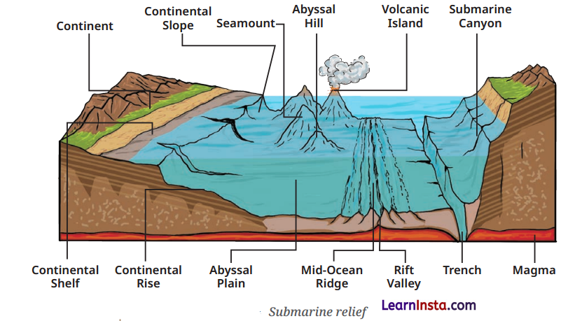
(i) How do you think these oceanic features would have been formed?
Answer:
The oceanic features shown in figure, such as the Continental Shelf, Continental Slope, Abyssal Plain, Mid-Ocean Ridge, Rift Valley, Seamount. Submarine canyons and trenches were formed through different geological processes. The chapter specifically states that the Mid-Ocean Ridge is formed by volcanic activity. while seamounts are usually volcanic in origin, and some may be flattened by wave action over a long period to form guyots.
(ii) Which part of the ocean floor appears deep and shallow?
Answer:
The Continental Shelf appears to be the shallow part of the ocean floor because it is the submerged, shallow edge of a continent. The Abyssal Plain is deep, while ocean trenches represent the deepest parts of the ocean. The Continental Slope lies between the shallow continental shelf and the deeper ocean floor.
(iii) How do you think these underwater features would have an effect on marine life and ocean movements?
Answer:
These underwater features can provide different habitats for marine life and influence the movement of ocean water. For example, the Continental Shelf is rich in marine life and resources, while the different depths and landforms of the ocean floor create varied underwater environments. The chapter also explains that ocean water is constantly moving through waves, tides, and currents, which shape the Earth’s surface and support marine life.
Question 2.
Find out the names of some famous sea beaches in our country and locate them on the map of India. (Page No. 5)
Answer:
Do it yourself.
Question 3.
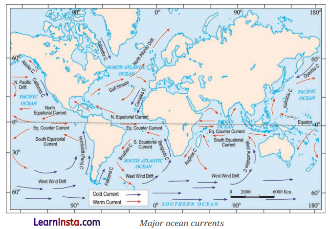
Observe the below map and take a note on ocean currents along the coastline of India. What is the nature of ocean currents? ( Page 8)
Answer:
The ocean currents along the coast of India are mainly influenced by the movement of seawater in the Indian Ocean. Ocean currents are continuous streams of seawater that may be warm or cold. They influence coastal temperature, marine life, and fishing.
Question 4.
Most deaths during the 2004 Indian Ocean tsunami occurred in Indonesia. However, the Island of Simeulue was largely spared from the disaster. Researchers suggest that this was partly because of local folklore, passed down through generations, that helped residents recognise the warning signs of a tsunami and respond quickly. Talk to your elders and find out whether similar folk traditions or stories related to natural disasters exist in your culture. Share these with your classmates and discuss how traditional knowledge can help communities stay safe. (Page No. 9 -10)
Answer:
Do it yourself.
Question 5.
Maritime disputes are conflicts or disagreements between countries over territory, resources, or rights in naval areas such as oceans, seas, or coastal regions. Can you find out some countries that have conflicts over their territorial sea waters? (Page No. 18)
Answer:
- Some countries involved in maritime disputes include:
- China and the Philippines in the South China Sea.
- China and Japan over the Senkaku/Diaoyu Islands in the East China Sea.
- Japan and South Korea over the Dokdo/Takeshima Islands.
- China and Vietnam over maritime areas in the South China Sea.
Think About It
Question 1.
Observe the map (Major ocean currents) carefully and note the movement patterns of cold and warm currents. Do you think these currents affect the temperature of nearby coastal regions’?
Answer:
Yes, warm and cold ocean currents affect the temperature of nearby coastal regions. The chapter explains that the Gulf Stream, a warm current, flows towards Norway and keeps its waters relatively warm, while the Labrador Current, a cold current, carries freezing water along the east coast of Canada and supports the formation of sea ice and icebergs even at lower latitudes.
Question 2.
If you receive a tsunami or cyclone alert on your phone right now, do you know the five steps your family should take to stay safe? (Page No. 14)
Answer:
The five steps to stay safe are:
- Stay calm and listen carefully to the official alert.
- Move quickly to a safe place away from the coast or low-lying areas.
- Follow evacuation instructions given by local authorities.
- Carry essential items such as water, medicines, a phone, and important documents.
- Stay informed through official messages and do not return until authorities declare the area safe.
Class 9 SST Part 2 Chapter 1 Question Answer
Questions and Activities (Page No. 20)
Question 1.
How do different features of the ocean floor affect human activities such as fishing, transport, and underwater exploration?
Answer:
Different features of the ocean floor affect human activities in several ways. The continental shelf is shallow and rich in marine life and resources such as oil and gas, making it important for fishing and resource extraction. The continental slope, abyssal plains, ocean trenches, mid-ocean ridges, seamounts, and guyots create different underwater landscapes that influence marine life, ocean movements, and underwater exploration.
The ocean floor also affects the availability of resources and the study and mapping of underwater areas. known as bathymetry. Thus, submarine relief influences fishing. navigation and transport, resource use, and underwater exploration.
Question 2.
How do waves, tides, and ocean currents influence climate, marine life, and human activities around the world?
Answer:
Waves, tides, and ocean currents play an important role in influencing climate, marine life, and human activities around the world. Waves shape coastlines through erosion and sediment transport and can also cause damage during storms. Tides cause the regular rise and fall of ocean water. High tides help ships enter harbours, support fishing by bringing fish closer to the shore, and can also be used to generate tidal energy.
Ocean currents are continuous movements of water that can be warm or cold. They influence the temperature of coastal regions, and areas where warm and cold currents meet become rich fishing grounds because they contain nutrients that support a variety of fish. Thus, waves, tides, and currents affect climate, marine ecosystems, fishing, navigation, coastal activities, and energy production.
Question 3.
Describe the importance of marine resources.
Answer:
Marine resources are very important for food security, livelihoods, economic activities, and maintaining a healthy environment. They include fish and seafood, biodiversity, oil and natural gas, minerals, sand and gravel, tidal and wave energy, tourism, and ecosystems such as coral reefs.
Fishing and aquaculture provide livelihoods to many people, while oceans support biodiversity and many plant and animal species. Marine resources also provide energy, materials, trade, and tourism opportunities. Therefore, marine resources should be used responsibly and sustainably so that marine ecosystems are protected, and future generations can benefit from them.
Question 4.
Draw a poster that encourages people to protect marine resources. Include a slogan (like Save Our Seas or Fish for the Future) and explain your message in 2-3 sentences.
Answer:
Do it yourself.
Question 5.
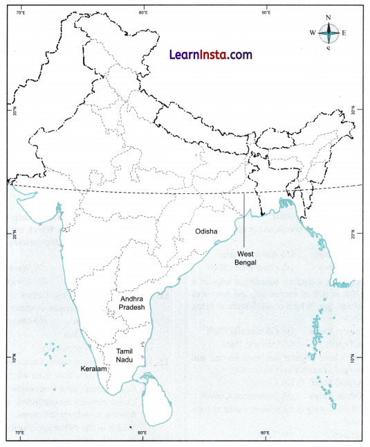
Using a map of India, mark at least five coastal states that might need tsunami warnings.
Answer:
Question 6.
Work in a group and act out what would happen when a cyclone warning is issued. Highlight what role different people, like scientists, officials, and coastal villagers, would play.
Answer:
When a cyclone warning is issued, different people play important roles to protect coastal communities:
Scientists: They monitor storms using advanced technologies and predict cyclones at an early stage.
They providë information about the cyclone and its possible effects.
Government officials: They receive the warnings and communicate them to state governments, emergency response teams, and the public. They help organise evacuation, cyclone shelters, and emergency response.
Coastal villagers: They listen to official warnings, move to safe places or cyclone shelters, and follow the safety instructions given by authorities.
Emergency response teams: They help people during evacuation and emergency situations and support rescue and relief activities.
Question 7.
Suppose a foreign ship is sailing through India’s territorial sea. What principle allows the ship to pass through these waters, subject to certain conditions?
Answer:
The principle is called innocent Passage. It allows a foreign ship to pass through India’s territorial waters as long as it does not threaten India’s peace, good order, or security. The ship must move continuously, except in emergencies or cases of breakdown. This right does not permit activities such as fishing, military operations, or other non-peaceful actions.
Question 8.
A country has an Exclusive Economic Zone (EEZ) extending up to 200 nautical miles from its baseline. What rights does the country have over the natural resources in this zone?
Answer:
The Exclusive Economic Zone (EEZ) extends up to 200 nautical miles from the baseline. In this zone, a country has special rights to use ocean resources such as fish, oil, and gas. However, the country does not fully own or control the waters of the EEZ, and ships from other countries may still pass through peacefully.
Question 9.
Create a model of an ocean with ship routes, protected zones, and safety measures. Based on the model, explain how it follows maritime laws and protects the ocean.
Answer:
Do it yourself.