Practice with Class 9 Social Science Extra Questions and Class 9 SST Part 2 Chapter 1 Oceans and Life Extra Questions to improve your exam performance.
Oceans and Life Class 9 Extra Question Answer
Extra Questions of Oceans and Life Class 9
Oceans and Life Class 9 Very Short Question Answer
Question 1.
What is meant by ocean relief? Name any two features of ocean relief.
Answer:
Ocean relief refers to the physical features found on the ocean floor. Two important features are the continental shelf and ocean trenches.
Question 2.
Why is the continental shelf important?
Answer:
The continental shelf is rich in marine life and resources such as oil and gas. It also supports various human activities related to marine resources.
Question 3.
Differentiate between a seamount and a guyot.
Answer:
A seamount is an underwater mountain, usually volcanic, that does not reach the sea surface. A guyot is a flat-topped underwater mountain, usually formed when a former seamount is eroded and submerged.

Question 4.
How do waves shape coastal areas?
Answer:
Waves act as coastal architects by causing erosion and transporting sediments. They form features such as sea caves, arches, stacks, and stumps, as well as depositional features such as beaches.
Question 5.
What are tides? Mention one importance of tides.
Answer:
Tides are the rhythmic rise and fall of ocean water. They are important for navigation because high tides raise the water level near the shore, helping ships enter harbours more easily.
Question 6.
Differentiate between spring tides and neap tides.
Answer:
Spring tides occur during full and new moons when the Sun, Earth, and Moon are aligned, producing a greater tidal range. Neap tides occur during the first- and third-quarter phases of the Moon and have a smaller tidal range.
Question 7.
What are ocean currents? Mention any one factor responsible for their movement.
Answer:
Ocean currents are continuous streams of water flowing across the ocean in definite directions. They are influenced by factors such as winds, Earth’s rotation, temperature and salinity differences, and the shape of continents and ocean basins.
Question 8.
Why are regions where warm and cold currents meet important for fishing?
Answer:
These regions are rich in nutrients and support a large variety of fish. Therefore, they become important fishing grounds for fishing communities.
Question 9.
What is an Early Warning System? Why is it important?
Answer:
An Early Warning System detects hazards such as cyclones and tsunamis and provides timely warnings. It helps people. Communities and governments take preventive action and evacuate to safer places.
Question 10.
What is the role of Ocean Bottom Pressure Recorders in tsunami warning systems?
Answer:
Ocean Bottom Pressure Recorders are placed on the seafloor to detect the passage of tsunami waves. They help confirm whether a tsunami threat exists after an undersea earthquake is detected.
Question 11.
What are marine resources? Give two examples.
Answer:
Manne resources are materials and features found in oceans that have intrinsic or economic value. Fish and seafood, oil, and natural gas are examples of marine resources.
Question 12.
What is meant by the Blue Economy?
Answer:
The Blue Economy refers to the sustainable use of ocean resources to promote economic growth, improved livelihoods and jobs while preserving the health of marine ecosystems.
Question 13.
What is an Exclusive Economic Zone (EEZ)?
Answer:
An EEZ extends up to 200 nautical miles from a country’s coast. A country has special rights to use resources such as fish, oil, and gas in this zone, although it does not fully own or control the waters.
Question 14.
What is meant by innocent passage?
Answer:
Innocent passage allows foreign ships to pass through a country’s territorial waters as long as they do not threaten its peace, good order, and security. The passage must be continuous and peaceful.
Question 15.
Why are maritime rules and regulations important?
Answer:
Maritime rules help ensure safe and peaceful activities at sea. They regulate ships. prevent accidents and pollution, protect trade routes, and help countries cooperate and settle maritime disputes.
Oceans and Life Class 9 Short Question Answer
Question 1.
Explain how the different features of ocean relief influence human activities and marine life.
Answer:
- The continental shelf is rich in marine life and resources such as oil and gas.
- Ocean trenches, abyssal plains, and underwater mountains provide different habitats for marine organisms.
- Knowledge of submarine relief is important for resource availability and undersea exploration.
Question 2.
Explain how ocean waves contribute to the formation of coastal landforms.
Answer:
- Waves erode rocks along the coastline through hydraulic action and abrasion.
- Continuous erosion can form sea caves, arches, stacks, and stumps.
- Waves also transport and deposit sediments, forming features such as beaches.
Question 3.
Why are tides important for coastal activities? Give three reasons.
Answer:
- High tides raise the water level and help ships enter harbours more easily.
- Tidal information helps ships safely navigate shallow coastal areas and ports.
- High tides bring many fish closer to the shore, supporting fishing activities.
Question 4.
Explain three factors that influence ocean currents.
Answer:
- Winds help move ocean water across the surface.
- Earth’s rotation produces the Coriolis force, which changes the direction of moving water.
- Differences in temperature and salinity, along with the shape of continents and ocean basins. also influence currents.
Question 5.
How do ocean currents influence coastal regions and fishing activities?
Answer:
- Warm currents can raise the temperature of nearby coastal waters.
- Cold currents can bring colder water to coastal regions and influence local conditions.
- Where warm and cold currents meet, nutrient-rich waters support large numbers of fish and create important fishing grounds.
Question 6.
Describe the main stages through which a tsunami warning is issued.
Answer:
- Seismic stations detect undersea earthquakes in real time.
- Ocean Bottom Pressure Recorders confirm the passage of tsunami waves. while tide gauges and radars track changes in sea level.
- Alerts are then sent through satellites, SMS, and other communication channels to officials and the public.
Question 7.
Explain how technology and communication help protect coastal communities from cyclones.
Answer:
- Cyclone Warning Services and Marine Weather Services continuously monitor storms along India’s coasts.
- The Storm Surge Early Warning System forecasts cyclone-induced storm surges and coastal inundation.
- Warning systems, cyclone shelters and communication networks help communities and authorities take timely action.
Question 8.
Explain the importance of marine resources to human life and the economy.
Answer:
- Fish and other marine resources provide food and support fishing and aquaculture livelihoods.
- Oceans provide resources such as minerals, oil, natural gas, and renewable blue energy.
- Sea-based trade and coastal tourism provide employment and contribute to economic activities.
Question 9.
How does the Blue Economy promote sustainable development?
Answer:
- It promotes the sustainable use of ocean resources for economic growth, livelihoods, and jobs.
- It aims to reduce marine pollution and protect marine ecosystems.
- It encourages responsible fishing, conservation of marine areas, and action against ocean acidification.
Question 10.
Explain how international maritime rules help maintain safety and cooperation at sea.
Answer:
- Maritime regulations provide common rules for ships and help prevent collisions and accidents.
- They protect the marine environment and reduce pollution from ships.
- They help countries cooperate, safeguard trade routes, and settle disputes over marine resources and boundaries.
Oceans and Life Class 9 Long Question Answer
Question 1.
Explain the different types of marine resources and their importance.
Answer:
- Marine resources are materials and features of the ocean that have intrinsic or economic value.
- Living resources include fish, marine organisms, bioactive natural products, and submerged aquatic vegetation.
- Non-living resources include minerals, oil, natural gas, and gas hydrates.
- Oceans also provide non-conventional energy such as offshore wind, tidal, wave, and current energy.
- These resources support food supply, livelihoods, biodiversity, Energy production, trade, and tourism.
Question 2.
Describe the major types of fish habitats found in the oceans.
Answer:
- Coastal or neritic fish are mainly found over the continental shelf, generally up to about 200 metres deep.
- Oceanic fish live beyond the continental shelf in waters deeper than 200 metres.
- Epipelagic fish live near the ocean surface where sunlight is available.
- Pelagic fish live in the open water away from the ocean floor, while demersal fish live close to the bottom.
- Benthopelagic fish live above the ocean floor, whereas benthic fish live directly on or in the seabed.
Question 3.
Explain the importance of the Blue Economy for sustainable development.
Answer:
- The Blue Economy promotes the sustainable use of ocean resources for economic growth.
- It supports livelihoods and creates employment through activities such as fishing, tourism, and maritime industries.
- It aims to reduce marine pollution and protect marine ecosystems.
- It encourages responsible fishing, conservation of marine areas, and action against ocean acidification.
- It is linked with Sustainable Development Goal 14, which focuses on protecting and sustainably using oceans and marine resources.
Question 4.
Why are the high seas considered a global common? Explain the rights and challenges associated with them.
Answer:
- The high seas lie beyond the Exclusive Economic Zones of individual countries and are not under the control of any single country.
- They cover about 64% of the world’s oceans and are treated as a global common.
- Countries have rights such as navigation, fishing, flying over the area, and laying undersea cables.
- They may also undertake lawful activities such as constructing permitted structures and exploring marine minerals.
- Overfishing, Illegal fishing, resource conflicts, enforcement difficulties, and navigation safety are major challenges in managing the high seas.
Question 5.
Explain the significance of maritime laws and regulations for the safe use of oceans.
Answer:
- Maritime laws provide common rules for ships operating in oceans and international waters.
- They help prevent accidents and collisions by establishing rules about lookout, safe speed, and giving way.
- Navigation rules specify the use of lights, sound signals. shapes, and radio communication.
- MARPOL helps reduce pollution caused by ships and supports protection of the marine environment.
- Maritime regulations also promote cooperation, protect trade routes, safeguard sailors and coastal communities. and help settle disputes.
Question 6.
Describe how GEMINI technology helps fishermen during hazardous weather conditions.
Answer:
- GEMINI is a communication device designed to provide important information to fishermen at sea.
- It receives information from the GAGAN satellite system and transfers it to a mobile phone through Bluetooth.
- The system provides alerts about high waves, strong winds. cyclones, and tsunamis.
- It also provides information related to fishing zones, current speeds, bathymetry, and risk management.
- The device supports communication up to about 50 nautical miles, while an upgraded pilot system is expected to extend this range.
Question 7.
Explain the stages involved in India’s tsunami warning system.
Answer:
- Seismic stations detect undersea earthquakes that may generate a tsunami.
- Ocean Bottom Pressure Recorders help confirm whether a tsunami has passed through the ocean.
- Coastal tide gauges and radars monitor changes in sea level as the waves approach the coast.
- Warning information is transmitted through satellites to concerned agencies and officials.
- Alerts are then communicated to the public through SMS and other channels, while public awareness and training help communities respond effectively.
Question 8.
Explain how the different maritime zones provide rights and responsibilities to coastal countries.
Answer:
- Territorial waters allow a coastal country to exercise control over activities such as customs. immigration and pollution, subject to innocent passage.
- The contiguous zone extends up to 24 nautical miles from the baseline and permits limited control over certain matters.
- The EEZ extends up to 200 nautical miles and gives the coastal country special rights over resources such as fish, oil, and gas.
- Foreign ships generally retain rights of peaceful passage through relevant maritime zones under international rules.
- Beyond national maritime zones, the high seas are treated as a global common where countries have specified rights under international law.
Oceans and Life Class 9 Source Based Questions
Read the sources given below and answer the questions that follow:
Question 1.
High tides are important for navigation because they raise the water level near the shore, allowing ships to enter harbours more easily. In ports and coastal areas, tidal information is essential, as tidal ranges in some ports can reach 4-5 metres. The Gulf of Khambhat has one of the highest tidal ranges, at about 12 metres. Before a ship berths at a port, it must check both the water depth and the tidal range to ensure safe docking, especially during low tide. Some sea channels, such as the Singapore Strait, contain shallow areas. Hence, ships such as Very Large Crude Carriers (VLCCs) passing through these regions often wait for hours to transit only during high tide to ensure sufficient water depth and avoid running aground.
(i) Why are high tides important for navigation?
Answer:
High tides raise the water level near the shore, allowing ships to enter harbours more easily.
(ii) Which place has one of the highest tidal ranges at about 12 metres?
Answer:
The Gulf of Khambhat.
(iii) Why do Very Large Crude Carriers (VLCCs) sometimes wait for high tide while passing through the Singapore Strait?
Answer:
- Some parts of the Singapore Strait are shallow and may not have sufficient water depth during low tide.
- VLCCs wait for high tide to ensure enough water depth and avoid running aground.
Question 2.
Oceans and seas can give rise to sudden natural hazards such as cyclones, which are large rotating storms, and tsunamis, which are giant waves caused by earthquakes. To protect people from such dangers, scientists have developed Early Warning Systems that work like giant alarm systems for coastal areas. To reduce risks, people, communities, and governments must act in advance. Early Warning Systems help detect cyclones and tsunamis, predict disasters, and issue timely warnings so that people can evacuate and stay safe.
(i) What are tsunamis?
Answer:
Tsunamis are giant waves caused by earthquakes.
(ii) What is the purpose of an Early Warning System?
Answer:
It helps detect hazards and issue timely warnings.
(iii) How do Early Warning Systems help protect people from cyclones and tsunamis?
Answer:
- They help detect cyclones and tsunamis and predict possible disasters.
- They issue timely warnings so that people can evacuate and stay safe.
Oceans and Life Class 9 Picture Based Questions
Observe the pictures nd answer the following questions:
Question 1.
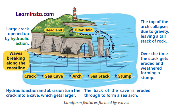
(i) What landform is formed when a sea cave is eroded through from one side to the other?
Answer:
Sea arch.
(ii) What is the landform left after a sea stack is further eroded?
Answer:
Stump.
(iii) How are a sea cave, sea arch, sea stack and stump formed by wave erosion?
Answer:
- Waves erode cracks in a headland, gradually forming a sea cave and then a sea arch.
- When the arch collapses, a sea stack is left, which is further eroded to form a stump.
Question 2.
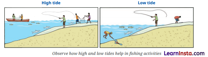
(i) What is shown in the left-hand image?
Answer:
High tide.
(ii) What happens to the water level during low tide?
Answer:
The water level falls and moves away from the shore.
(iii) How are high tide and low tide different?
Answer:
- During high tide, the water rises to its highest level and covers much of the shore.
- During low tide, the water falls to its lowest level and moves away from the shore.
Oceans and Life Class 9 Map Based Questions
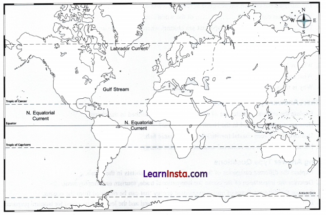
On the world map, label and locate the following:
(i) Identify the warm ocean current shown along the eastern coast of North America.
(ii) Identify the cold ocean current flowing along the eastern coast of Canada.
(iii) Name the ocean current shown flowing westward along the Equator in the Pacific Ocean.
Answer:
(i) Gulf Stream
(ii) Labrador Current
(iii) N. Equatorial Current
Class 9 Oceans and Life Extra Questions for Practice
Multiple Choice Questions
Question 1.
Which underwater mountain is taller than Mount Everest when measured from its base on the ocean floor?
(a) Seamount
(b) Guyot
(c) Mauna Kca
(d) Mid-Ocean Ridge
Question 2.
Which device receives information from the GAGAN satellite system and transmits it to a mobile phone through Bluetooth?
(a) OBPR
(b) GEMINI
(c) COLREGs
(d) MARPOL
Question 3.
Approximately what percentage of global trade by volume is carried by sea?
(a) 25%
(b) 50%
(c) 75%
(d) 90%
Question 4.
Which of the following is a non-conventional source of marine energy?
(a) Coal
(b) Petroleum
(c) Offshore wind energy
(d) Natural gas
Question 5.
How many names were submitted by the 13 member countries for naming cyclones in the North Indian Ocean?
(a) 69
(b) 100
(c) 169
(d) 200
Question 6.
Assertion (A): A nautical mile is commonly used in maritime navigation.
Reason (R): One nautical mile is exactly 1,852 metres and is based on one minute of latitude.
(a) Both A and R are true, and R is the correct explanation of A.
(b) Both A and R are true, but R is not the correct explanation of A.
(c) A is true, but R is false.
(d) A is false, but R is true.
Fill in the blanks
1. The device used to help fishermen receive safety and weather-related information is called …………………………. .
2. The international convention designed to reduce pollution from ships is known as ……………………….. .
3. The high seas cover about …………………………. of the world’s oceans.
4. The …………………………….. Strait is an important sea channel where some areas are shallow.
Very Short Answer Type Questions
Question 1.
What is meant by a nautical mile?
Question 2.
What is bathymetry?
Question 3.
What are benthic and pelagic fish?
Question 4.
Why is the sea important for international trade?
Short Answer Type Questions
Question 1.
Explain the cultural significance of oceans in India as described in the chapter.
Question 2.
How are cyclones named in the North Indian Ocean?
Question 3.
Distinguish between coastal (neritic) fish and oceanic fish.
Question 4.
Name any four non-conventional sources of marine energy.
Long Answer Type Questions
Question 1.
Explain the different categories of fish according to their habitats in the ocean.
Question 2.
Describe the importance of the ocean for international trade, tourism, and employment.
Question 3.
Explain the different forms of non-conventional energy that can be obtained from the oceans.
Question 4.
Describe the major features of the 2004 Indian Ocean tsunami and the lessons it provided for tsunami preparedness
and public awareness.