These Class 7 Social Science Worksheet and Class 7 SST Chapter 1 Geographical Diversity of India Worksheet with Answers are excellent for board exam practice.
Class 7 SST Chapter 1 Geographical Diversity of India Worksheet
Class 7 Geographical Diversity of India Worksheet
Worksheet On Geographical Diversity of India Class 7 – Geographical Diversity of India Worksheet Class 7
Multiple Choice Questions
Question 1.
Which country is not a part of the Indian Subcontinent?
(a) Bhutan
(b) Sri Lanka
(c) Myanmar
(d) Afghanistan
Question 2.
The Arabian sea stands on the:
(a) Eastern boundary
(b) Northern boundary
(c) Western boundary
(d) Southern boundary
Question 3.
The Himalayas are known as:
(a) A vital estuary of Asia
(b) The point of origin of the Ganga
(c) Water Tower of Asia
(d) Biggest delta of India
Question 4.
India was a part of:
(a) Gondwana
(b) China
(c) Africa
(d) Poland
Question 5.
Which part of the Himalayas is called the lower Himalayas?
(a) Shivalik
(b) Himachal
(c) Himadri
(d) Gaumukh
Question 6.
Which region experiences the highest rain in the world?
(a) The Gangetic plains
(b) The northern hills
(c) The Sundarbans
(d) Ladakh
Question 7.
The golden dunes are formed by:
(a) Rainwater
(b) Clay
(c) Sand
(d) Stones
Question 8.
Which hills support the mining and construction in India?
(a) Khasi
(b) Aravalli
(c) Garo
(d) Jantia
Question 9.
Lakshadweep is a:
(a) Coral island
(b) Tidal
(c) Artificial island
(d) Archipelago
Question 10.
Sundarbans are located in the delta of:
(a) The Ganga and the Brahmaputra
(b) The Narmada and the Kaveri
(c) The Indus and the Ganga
(d) The Brahmaputra and the Kaveri
![]()
Assertion and Reason Questions
There are two statements marked as Assertion (A) and Reason (R). Mark your answer as per the codes provided below:
Question 1.
Assertion (A): Meghalaya plateau is known for its lush greenery and breathtaking waterfalls.
Reason (R) This region experiences one of the highest rainfall in the world.
Codes:
(a) Both (A) and (R) are true, and R is the correct explanation of (A).
(b) Both (A) and (R) are true, but (R) is not the correct explanation of (A).
(c) (A) is true, but (R) is false.
(d) (A) is false, but (R) is true.
Question 2.
Assertion (A): The Thar is a vast arid region.
Reason (R): It has a vast stretch of golden dunes, rugged terrain, and a wide- open sky.
Codes:
(a) Both (A) and (R) are true, and R is the correct explanation of (A).
(b) Both (A) and (R) are true, but (R) is not the correct explanation of (A).
(c) (A) is true, but (R) is false.
(d) (A) is false, but (R) is true.
Fill in the Blanks with the Words given in the Box Below
| Barren, natural, Royal Bengal Tiger, Meghalaya, seventh |
1. The northeast hills are part of the _________ plateau.
2. The Sundarbans are home to _________
3. _________ Island is the only active volcano in India.
4. India is the _________ largest country in the world.
5. The Himalayas are considered the _________ barrier in India.
State Whether the following Statements are True or False
1. The geographical features play no role in shaping India’s climate and culture.
2. The Indus river is a major tributary of the Ganga.
3. The great Himalayan National Park does not feature flora and fauna.
4. Ladakh has a rugged landform with very little rainfall.
5. The Thar desert spans the states of Rajasthan, Gujarat, Haryana and Punjab.
Match the Contents in Column A with those in Column B
| Column A | Column B |
| 1. Thar Desert | A. The Hemis Festival |
| 2. Ladakh | B. Gangotri Glacier |
| 3. Shivalik | C. Golden Dunes |
| 4. Gaumukh | D. Natural Barriers |
| 5. The Himalayas | E. Rolling Hills |
Choose the correct option:
(a) 1-C, 2-B, 3-C, 4-D, 5-E
(b) 1-B, 2-A, 3-C, 4-D, 5-E
(c) 1-C, 2-A, 3-E, 4-B, 5-D
(d) 1-D, 2-B, 3-C, 4-A, 5-E
Very Short Answer Type Questions
Question 1.
What are the three main mountain ranges of the Himalayas?
Answer:
___________________________
___________________________
___________________________
Question 2.
Which countries are part of the Indian Subcontinent?
Answer:
___________________________
___________________________
___________________________
Question 3.
With which landmass India collided to form the Himalayas?
Answer:
___________________________
___________________________
___________________________
Question 4.
List the states in different parts of the Himalayas.
Answer:
___________________________
___________________________
___________________________
Question 5.
Name a cold desert of India.
Answer:
___________________________
___________________________
___________________________
Question 6.
Which regions are considered the outposts of India?
Answer:
___________________________
___________________________
___________________________
![]()
Short Answer Type Questions
Question 1.
What are the similarities between the Gangetic plains and the Northern hills?
Answer:
___________________________
___________________________
___________________________
Question 2.
What are Golden Dunes?
Answer:
___________________________
___________________________
___________________________
Question 3.
How do the Himalayas help in maintaining climate balance?
Answer:
___________________________
___________________________
___________________________
Question 4.
Describe the land formation of the Peninsular Plateau.
Answer:
___________________________
___________________________
___________________________
Long Answer Type Questions
Question 1.
Describe the lifestyle of people living in the Thar region.
Answer:
___________________________
___________________________
___________________________
Question 2.
What role do the Aravallis play ¡n shaping the geography and climate of northwestern India?
Answer:
___________________________
___________________________
___________________________
Question 3.
Describe the location and features of the Sundarbans in West Bengal.
Answer:
___________________________
___________________________
___________________________
Case Based Questions
Read the given excerpt and answer the questions that follow:
The East Coast lies between the Eastern Ghats and the Bay of Bengal, stretching from the Ganga delta to Kanyakumari. It has wide plains and major river deltas, including Mahanadi, Godavari, Krishna, and Kaveri. Important water bodies like Chilika Lake and Pulicat Lake (a lagoon, which is a body of water separated from larger bodies of water by a natural barrier) are found here.
(a) Where is the East Coast of India located?
(b) Which major rivers flow through this coast?
(c) List two prime water bodies of the East Coast.
(d) What is a Lagoon?
Answer:
___________________________
___________________________
___________________________
Skill-Based Question
Question 1.
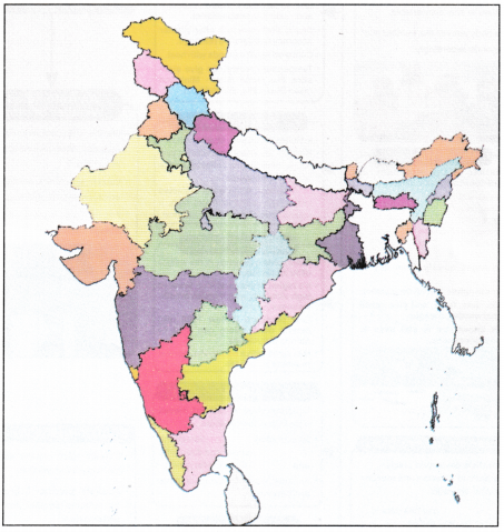
Look at the political map of India. Find out the Barren Island. Discuss its significance and differences from the other islands of India.
Answer:
___________________________
___________________________
___________________________
Competency-Based Question
Question 1.
How do you think coasts are valuable limbs of a country? Discuss the vital features of India’s Coastlines.
Answer:
___________________________
___________________________
___________________________
Picture-Based Questions
Look at the given picture below and answer the questions that follow.
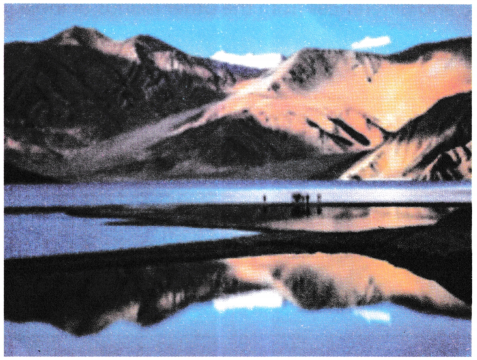
(a) identify this picture.
(b) Where is it situated?
(c) Which type of water this iake has?
(d) List two mountain areas near this lake.
(e) Which is the most contained mineral of this lake?
Answer:
___________________________
___________________________
___________________________
Map Work
On the given political map of India mark:
(a) The Sundarbans
(b) Khasi and Jantia Hills
(c) Lakshadweep Islands
(d) Chilika Lake
(e) The Thar Desert