Our Country India Class 6 Geography Chapter 7 Extra Questions and Answers Social Science CBSE Pdf free download are part of Extra Questions for Class 6 Social Science. Here we have given NCERT Extra Questions for Class 6 Social Science SST Geography Chapter 7 Our Country India.
You can also practice NCERT Solutions for Class 6 Geography Chapter 7 Questions and Answers on LearnInsta.com.
Class 6 Geography Chapter 7 Extra Questions and Answers Our Country India
Our Country India Class 6 Extra Questions and Answer Geography Chapter 7 Very Short Answers Type
Question 1.
State the location of the Himalaya and the seas bounded to India.
Answer:
India is bounded by the lofty Himalayas in the north, Arabian Sea in the west, Bay of Bengal in the east and Indian Ocean in the south.
Question 2.
How much is area of India?
Answer:
India has an area of about 3.28 million sq. km.
Question 3.
What is distance between Kashmir to Kanyakumari?
Answer:
The distance between Kashmir to Kanyakumari (north to south) is about 3,200 km.
Question 4.
What is distance from east corner to west corner?
Answer:
East to West (Arunachal Pradesh to Kuchchh) is about 2,900 km.
Question 5.
What contributes to India’s diversity?
Answer:
India has a diversity of landforms, climate, vegetation, wildlife, language, culture etc.
Question 6.
Which country has the largest population over the world?
Answer:
China.
Question 7.
India is most populous country of the world after China, (second)
Question 8.
In which hemisphere is India located?
Answer:
India is located in the northern hemisphere.
Question 9.
Mention the expansion of India from south to north on latitudes.
Answer:
From south to north, main land of India extends between 8°4 ‘N and 37°6’N latitudes.
Question 10.
From west to east, India extends between and longitudes.
Answer:
68°7’E and 97°25’E
Question 11.
How much earlier does the Sun rise in the east than in the west?
Answer:
The Sun rises two hours earlier in the east (Arunachal Pradesh) than in the west (Gujarat).
Question 12.
Which longitude has been taken as the Standard Meridian of India?
Answer:
82°30’E longitude has been taken as the Standard Meridian of India.
Question 13.
Name of our island neighbours.
Answer:
Our island neighbours are – Sri Lanka and Maldives.
Question 14.
What do you mean by Palk Strait?
Answer:
Sri Lanka is separated from India by the Palk Strait.
Question 15.
How many States and Union Territories does India has?
Answer:
For administrative purposes, India is divided into 29 States and 7 Union Territories.
Question 16.
What is the Capital of India?
Answer:
Delhi is the Capital of India.
Question 17.
Which State is the largest in terms of area?
Answer:
In terms of area, Rajasthan is the largest state.
Question 18.
Which state is the smallest, in term of area?
Answer:
Goa is a smallest state.
Question 19.
On which basis have states been formed?
Answer:
States have been formed mainly on the basis of languages.
Question 20.
In how many parallel ranges are the Himalayan mountains divided?
Answer:
The Himalayan mountains are divided into three main parallel ranges.
Question 21.
What is Himadri?
Answer:
The northernmost range of the Himalaya is the Great Himalaya or Himadri.
Question 22.
What is the southernmost range of the Himalaya called?
Answer:
The ‘Shiwalik’ is the southernmost range.
Question 23.
What is peninsula?
Answer:
The peninsula is a piece of land that is surrounded by water on three sides.
Question 24.
How do western coastal plains look like?
Answer:
The western coastal plains are very narrow.
Question 25.
How do eastern coastal plains look like?
Answer:
The eastern Coastal plains are much broader.
Question 26.
Name of rivers flowing east and draining into Bay of Bengal.
Answer:
Mahanadi, Godavari, Krishna and Kaveri are east flowing rivers and drain into the Bay of Bengal.
Question 27.
In which Sea is Lakshadweep Island located?
Answer:
Lakshadweep Island is located in the Arabian Sea.
Question 28.
In which sea is Andman and the Nicobar Islands located?
Answer:
In Bay of Bengal.
Our Country India Class 6 Extra Questions and Answer Geography Chapter 7 Short Answers Type
Question 1.
Give the names of countries that share land boundaries with India.
Answer:
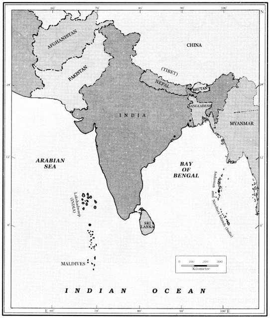
There are seven countries that share land boundaries with India. Their names are – Myanmar, Bhutan, Nepal, Tibet, China, Pakistan and Afghanistan.
Question 2.
Write few lines about Northern Indian plains?
Answer:
In the south of the Himalayas lie the Northern Indian plains. These are generally level and flat. The land here is fertile for cultivation and has high concentration of population.
Question 3.
Where is the Great Indian Desert located? How is it?
Answer:
In the western part of India lies the Great Indian Desert. It is dry, hot and sandy stretch of land. It has very little vegetation.
Question 4.
Describe the Peninsular Plateau lying in the south of northern plains in India?
Answer:
To the south of northern plains, lies the Peninsular Plateau. It is triangular in shape. This is a region with numerous hill ranges and valleys. On the border of it, oldest range of the world, Aravali hills are situated. The Vindhyas and the Satpuras are the important ranges. The rivers Narmada and Tapti flow through these ranges and drain into the Arabian Sea.
Question 5.
What do you mean by Corals and how do Coral Islands form?
Answer:
Corals are skeletons of tiny marine animals called Polyps. When the living polyps die, their skeletons are left. Other polyps grow on top of the hard skeleton which grows higher and higher, thus forming the coral islands.
Question 6.
What do you mean by Alluvial deposits?
Answer:
These are very fine soils, brought by rivers and deposited in the river basins.
Question 7.
Define the Tributary.
Answer:
A river or stream which contributes its water to a main river by discharging it into main river from either side.
Question 8.
What do you understand about Peninsular Plateaus? Describe it.
Answer:
Peninsular Plateau: “It is a piece of land that is surrounded by water on three sides.” To the south of northern plains lies the Peninsular Plateau. It is triangular in shape. This is a region with numerous hill ranges and valleys.
On the border of it, oldest range of the world, Aravali hills are situated. The Vindhyas and the Satpuras are the important ranges. The rivers Narmada and Tapti flow through these ranges and drain into Arabian Sea. On the west of plateau lie Western Ghats and on the east lie the Eastern Ghats.
Our Country India Class 6 Extra Questions and Answer Geography Chapter 7 Long Answers Type
Question 1.
Distinguish between Western Ghats and Eastern Ghats.
Answer:
Western Ghats and Eastern Ghats can be distinguished as under:
table
Question 2.
Describe the parallel range of the Himalayan Mountains.
Answer:
The Himalayan Mountains are divided into three main parallel ranges:
- Great Himalayas: It is northernmost range of the Himalayas. This range is also called Himadri. In this range, Mr. Everest, the world’s highest peak is located.
- Middle Himalaya: This part is located in the south of Himadri. Many popular hill stations are situated here. Other popular hill stations situated in this range are Shimla, Manali, Kullu etc.
- Shiwalik: The Shiwalik is the Southernmost range.
Question 3.
What do you understand about physical division? Describe them.
Answer:
Physical divisions are mainly Indian mountains, plateaus, plains, coasts and islands. These are the heads which cover almost all the physical aspect which make an easy study as whole.
(i) The Himalayas: The northernmost part is the Great Himalaya or Himadri. Middle Himalaya lies to the south of Himadri. Many popular hill stations are situated here. The ‘Shiwalik’ is the southernmost range.
(ii) Northern Plains: In the south of the Himalayas, lie the Northern Indian plains. These are generally level and flat. Land here is fertile for cultivation and high concentration of population.
(iii) Great Indian Desert: In the western part of India, lies the Great Indian Desert. In this region, rainfall is very poor. It is dry, hot and sandy stretch of land. It has very little vegetation.
(iv) Peninsular Plateau: To the south of northern plains lies the Peninsular Plateau. It is triangular in shape. This is a region with numerous hill ranges and valleys. On the border of it, oldest range of the world, Aravali hills are situated.
The Vindhyas and the Satpuras are the important ranges. The rivers Narmada and Tapti flow through these ranges and drain into Arabian Sea. On the west of plateau lie Western Ghats and on the east lie the Eastern Ghats.
(v) The coastal plains: The coastal plains lie to the west of the Western Ghats and the east of the Eastern Ghats. The western coastal plains are narrow while the eastern coastal plains are much broader.
(vi) Islands: Two groups of islands are integral part of the country. Lakshadweep Islands are located in the Arabian Sea and Andaman & Nicobar Islands in the Bay of Bengal.
Question 4.
Give the name of States and Union Territories of India along with their Capitals?
Answer:
Please insert details given at page No. 66 of Textbook
Picture Based Questions Class 6 Geography Chapter 7 Our Country India
Question 1.
On the outline map of India locate the countries that share land boundaries with India:
Answer:

Question 2.
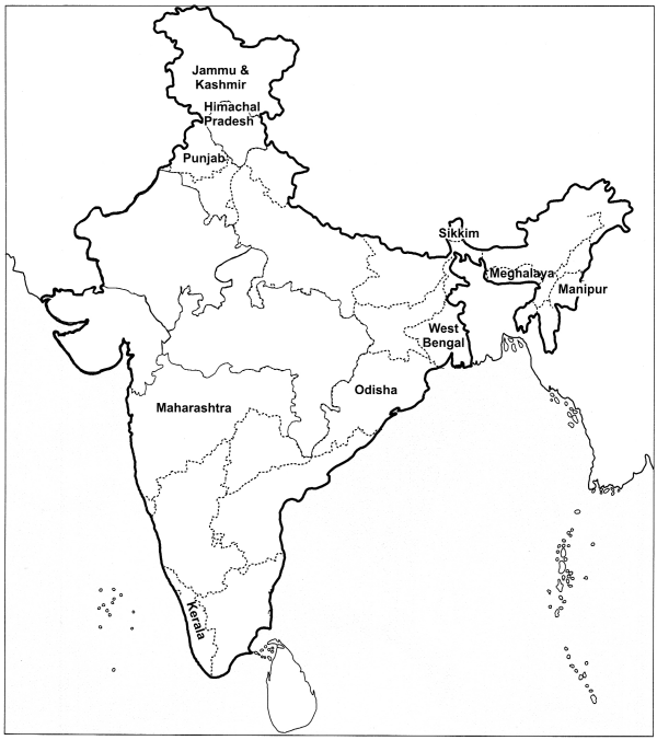
Locate the following states on the map of India:
(i) Sikkim
(ii) Manipur
(iii) Kerala
(iv) West Bengal
(v) Meghalaya
(vi) Himachal Pradesh
(vii) Odisha
(viii) Jammu and Kashmir
(ix) Maharashtra
(x) Punjab
Answer:

Question 3.
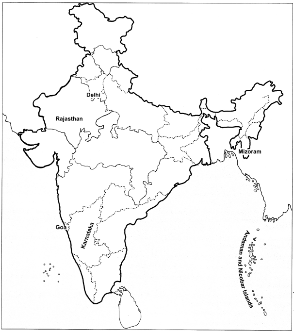
Locate the following on the map of India.
(a) The largest state on the basis of area
(b) The smallest state
(c) The state whose capital is Bengaluru
(d) The state whose capital is Aizawl
(e) Country’s capital
(f) The islands lying to the southeast of the Indian mainland in Bay of Bengal.
Answer:
(a) Rajasthan
(b) Goa
(c) Karnataka
(d) Mizoram
(e) Delhi
(f) Andaman and Nicobar Islands
