Students can access the CBSE Sample Papers for Class 11 Geography with Solutions and marking scheme Set 4 will help students in understanding the difficulty level of the exam.
CBSE Sample Papers for Class 11 Geography Set 4 with Solutions
Time : 3 Hours
Maximum Marks : 70
General Instructions:
- This question paper contains 30 questions. All questions are compulsory.
- This question paper is divided into five sections. Sections-A, B, C, D and E.
- Section A – Question number 1 to 17 are Multiple Choice Type Questions carrying 1 mark each.
- Section B – Question number 18 and 19 are Source Based Questions carrying 3 marks each.
- Section C – Question numbers 20 to 23 are Short Answer Type Questions carrying 3 marks each. Answer to these questions shall be written in 80 to 100 words.
- Section D – Question number 24 to 28 are Long Answer Type Questions carrying 5 marks each. Answer to these questions shall be written in 120 to 150 words.
- Section E – Question number 29 and 30 are Map based questions.
Section – A
Question 1.
There are two statements marked as Assertion (A) and Reason (R). Mark your answer as per the codes provided
below. 1
Assertion: Physical and human factors both are dynamic, not static.
Reason: The factors change over a period of time as a result of the interactive processes between the ever-changing Earth and ever-active human beings.
Options:
(A) Both (A) and (R) are true but (R) is not the correct explanation of (A)
(B) Both (A) and (R) are true and (R) is the correct explanation of (A)
(C) Both (A) and (R) are incorrect.
(D) (A) is correct but (R) is incorrect.
Answer:
Option (B) is correct.
Explanation: Both physical and human factors change over time and transform according to society due to which both are called dynamic but not static. Thus, both the assertion and the reason are true and reason correctly explains the assertion.
Question 2.
Consider the following and choose the correct answer with the help of given codes: 1
| Column I | Column II |
| i. Geography | 1. Various natural and social sciences |
| ii. Holistic discipline | 2. Description of the earth |
| iii. Three sets of geography | 3. Spatial organisation |
| iv. Geography derives data from | 4. When, why and how questions about the earth’s features |
Options:
Answer:
Option (C) is correct.
Explanation:
- Geography is a description of the Earth, originating from Greek words for Earth and description.
- Geography studies the ‘spatial organization’ and ‘spatial integration’ known as hostile discipline.
- Three sets of geography focus on when why and how questions of the earth’s features and phenomena.
- Geography relates to other sciences by deriving its data from various natural and social sciences.
Question 3.
Geography should be studied as an: 1
(A) integrated subject
(B) independent subject
(C) intermingled subject
(D) interlocked subject
Answer:
Option (B) is correct.
Explanation: Geography should be studied as an independent subject because it encompasses a wide range of topics and concepts related to the Earth’s physical and human environments, and it provides a comprehensive understanding of the world’s landscapes, cultures, and processes.
Question 4.
Consider the following statements about the stages of the nebular hypothesis and choose the correct answer with
the help of the given options: 1
I. Rapid movement of the ocean floor displaces a column of water during the tsunami.
II. Giant waves formed during tsunamis collide with the shore, causing massive damage.
Options:
(A) Both statements are true
(B) Only statement I is true
(C) Only statement II is true
(D) Both statements are wrong
Answer:
Option (A) is correct.
Explanation: The rapid movement of the ocean floor, often due to geological events like undersea earthquakes or volcanic eruptions, can indeed displace a column of water, setting off the initial disturbance for a tsunami.
ii. Tsunamis are characterized by the generation of giant waves in deep ocean waters. When these waves approach shallower coastal areas, they can indeed grow in height and collide with the shore, causing massive damage when they reach land. Thus, both statements are true.
Question 5.
Given below is a list of different ecological natural processes and their features, identify which of the following pair is not correctly matched. 1
| Column I | Column II |
| (A) Gradation | Wearing down through erosion |
| (B) Exogenic force | Internal forces |
| (C) Diastrophism | Moves elevate or build up landforms |
| (D) Volcanism | Eruption of molten rock |
Answer:
Option (B) is correct.
Explanation: Exogenic forces are known as external forces that result in wearing down (degradation) of relief/elevations and filling up (aggradation) of basins/depressions, on the earth’s surface.
Question 6.
…………….. processes involve the uplift or warping of large parts of the earth’s crust. 1
(A) Diastrophism
(B) Weathering
(C) Exfoliation
(D) Epeirogeny
Answer:
Option (D) is correct.
Explanation: Epeirogeny processes are geological phenomena that involve the uplift or warping of large parts of the Earth’s crust over long periods of time. These processes can lead to changes in the elevation and shape of continents and are associated with slow vertical movements of the Earth’s lithosphere.
Question 7.
Bars are submerged features and when bars show up above the water, they are called ………………. . 1
(A) Glacial till
(B) Moraines
(C) Barrier bars
(D) Ox-bow lakes
Answer:
Option (C) is correct.
Explanation: Bars are submerged landforms found underwater, often near coastlines or in rivers. When these bars become visible above the water, they are known as “Barrier bars.” These are typically sand or sediment deposits that can create barrier islands or beaches along coastlines.
Question 8.
Which layer of air has the greatest thickness at the equator? 1
(A) Troposphere
(B) Stratosphere
(C) Mesosphere
(D) Ionosphere
Answer:
Option (A) is correct.
Explanation: The troposphere is thickest at the equator as the heat is transported to great heights by convection currents.
Question 9.
The insolation received by the earth is in: 1
(A) long waves form
(B) short waves form
(C) medium waves form
(D) wide waves form
Answer:
Option (B) is correct.
Explanation: The solar energy received by the earth is as short waves that heat up the Earth.
Question 10.
Consider the following statements and choose the correct answer with the help of the given options: 1
Statement I: Biodiversity is important.
Statement II: It helps in understanding the role of each specie.
(A) Only statement I is correct
(B) Only statement II is correct
(C) Both the statements are correct, and statement II correctly explains statement I
(D) Both the statements are true but not related with each other
Answer:
Option (C) is correct.
Explanation: Biodiversity helps in understanding the role of each specie as each specie gives us some clue as to how life evolved and will continue to evolve and so it is important.
Question 11.
Arrange the occurrence of El Nino in correct order: 1
(i) Trade winds blow east to west across the surface of the tropical Pacific Ocean.
(ii) Brings warm moist air and warmer surface waters towards the western Pacific.
(iii) Keeping the central Pacific Ocean relatively cool.
(iv) Occurs every 3 to 5 years.
Options:
(A) i, ii, iii, iv
(B) iii, iv, ii, i
(C) ii, iv, iii, i
(D) i, iii, ii, iv
Answer:
Option (D) is correct.
Explanation: El Nino is a climatic phenomenon that disrupts the normal weather patterns in the tropical Pacific Ocean. It begins with the weakening of the trade winds (i) that usually blow from east to west across the ocean’s surface. This weakening reduces the upwelling of cold water in the central Pacific, causing it to remain relatively cool (iii).
As the trade winds weaken, warm moist air and warmer surface waters start to move eastward, away from the western Pacific (ii). El Nino events are not regular and occur approximately every 3 to 5 years (iv). This disruption in the ocean-atmosphere system can lead to various climatic effects worldwide, including altered rainfall patterns and increased temperatures in different regions.
Question 12.
Which of the following states does not experience continental climate? 1
(A) Punjab
(B) Haryana
(C) Rajasthan
(D) Thiruvananthapuram
Answer:
Option (D) is correct.
Explanation: Thiruvananthapuram being situated near the sea, experiences a moderate climate.
Question 13.
……………… forests are well stratified. 1
(A) Tropical Evergreen
(B) Tropical Deciduous
(C) Tropical Thorn
(D) Montane
Answer:
Option (A) is correct.
Explanation: These forests are covered with shrubs and creepers with short structured trees followed by tall trees.
Question 14.
The biosphere reserve situated in Uttarakhand includes parts of Chamoli, Almora, Pithoragarh and Bageshwar
districts is known as: 1
(A) Sunderbans Biosphere Reserve
(B) Nanda Devi Biosphere Reserve
(C) Gulf of Mannar Biosphere Reserve
(D) Kalka Devi Biosphere Reserve
Answer:
Option (B) is correct.
Explanation: It is located in the Himalayan Mountains in the northern part of India.
Study the given graph carefully and answer the following question.
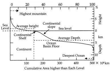
Question 15.
According to the graph, what is the average depth of the ocean? 1
(A) 11 km below the sea level
(B) 8 km below the sea level
(C) 4 km below the sea level
(D) 7 km below the sea level
Answer:
Option (C) is correct.
Explanation: According to the above-given graph, the average depth of the sea level is 4 km below the sea level.
Question 16.
According to the graph, what is the average height of the continent? 1
(A) 8 km above the sea level
(B) 1 km above the sea level
(C) 4 km above the sea level
(D) 3 km above the sea level
Answer:
Option (B) is correct.
Explanation: The average height of the continent is 1 km above sea level.
Question 17.
According to the graph, the deepest point of the ocean lies at: 1
(A) 11 km below the sea level
(B) 8 km below the sea level
(C) 4 km below the sea level
(D) 7 km below the sea level
Answer:
Option (A) is correct.
Explanation: The deepest point of the ocean lies at 11 km below the sea level.
Section – B
Question 18 & 19 are Source Based Questions.
Question 18.
Read the given Passage carefully and answer the questions that follow: 3
In mountainous areas, the decrease in temperature with increasing altitude leads to a corresponding change in natural vegetation. Mountain forests can be classified into two types, the northern mountain forests and . the southern mountain forests. The Himalayan ranges show a succession of vegetation from the tropical to the tundra, which changes with altitude. Deciduous forests are found in the foothills of the Himalayas. It is succeeded by the wet temperate type of forests between an altitude of 1,000-2,000 m. In the higher hill ranges of northeastern India, hilly areas of West Bengal and Uttaranchal, evergreen broad-leaf trees such as oak and chestnut are predominant. Between 1,500-1,750 m, pine forests are also well-developed in this zone, with Chir Pine as a very useful commercial tree. Deodar, a highly valued endemic species grows mainly in the western part of the Himalayan range.
Deodar is a durable wood mainly used in construction activities. Similarly, the Chinar and the walnut, which sustain the famous Kashmir handicrafts, belong to this zone. Blue pine and spruce appear at altitudes of 2,225-3,048 m. At many places in this zone, temperate grasslands are also found. But in the higher reaches, there is a transition to Alpine forests and pastures. Silver firs, junipers, pines, birchand rhododendrons, etc. occur between 3,000-4,000 m. However, these pastures are used extensively for transhumance by tribes like the Gujjars, the Bakarwals, the Bhotiyas and the Gaddis. The southern slopes of the Himalayas carry a thicker vegetation cover because of relatively higher precipitation than the drier north-facing slopes. At higher altitudes, mosses and lichens form part of the tundra vegetation. The southern mountain forests include the forests found in three distinct areas of Peninsular India viz; the Western Ghats, the Vindhyas and the Nilgiris. As they are closer to the tropics, and only 1,500 m above the sea level, vegetation is temperate in the higher regions, and subtropical on the lower regions of the Western Ghats, especially in Kerala, Tamil Nadu and Karnataka. The temperate forests are called Sholas in the Nilgiris, Anaimalai and Palani hills. Some of the other trees of this forest of economic.
a. Which type of forests are found in the foothills of the Himalayas?
b. Deodar, a highly valued endemic species grows mainly in which part of the Himalayan range?
c. In Nilgiris, Sholas is which type of forest?
Answer:
a. Deciduous Forests.
b. Western Part of the Himalayan Range.
c. Sholas are temperate forests in the Nilgiris.
Question 19.
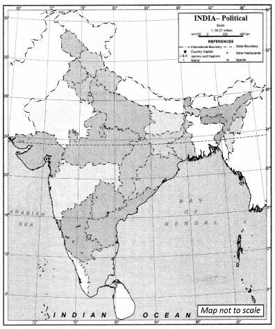
Observe the below-given Map of India and answer the following 3
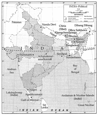
a. Which is the highest peak in India?
b. What is the hotspot of Andaman & Nicobar Islands?
c. Where does the Sundarbans located?
Answer:
a. Kanchenjunga is the highest peak in India
b. Great Nicobar
c. West Bengal
Section – C
Question numbers 20 to 23 are Short Answer Type Questions.
Question 20.
Name the experts who modified Nebular Hypothesis. 3
OR
How does the shadow zone emerge?
Answer:
In 1950, Otto Schmidt in Russia and Carl Weiz Scar in Germany revised the ‘Nebular Hypothesis’, though they differed in details. They were of the opinion that the sun was surrounded by solar nebula containing mostly hydrogen and helium along with what may be termed as dust.
The friction and collision of particles led to the formation of a disk-shaped cloud and the planets were formed through the process of accretion. However, scientists in later periods took up the problems of the origin of the universe rather than that of just the earth or the planets.
OR
Earthquake waves get recorded in Seismographs located at far-off locations. However, there exist some specific areas where the waves are not reported. Such a zone is called the shadow zone. The study of different events reveals that for each earthquake, there exists an altogether different shadow zone.
Question 21.
What is the significance of weathering? 3
Answer:
Significance of weathering:
- Weathering processes are responsible for breaking down the rocks into smaller fragments and preparing the way for the formation of not only regolith and soils but also erosion and mass movements.
- Biomes and biodiversity are basically a result of forests (vegetation) and forests depend upon the depth of weathering mantles.
- Weathering of rocks and deposits helps in the enrichment and concentrations of certain valuable ores of iron, manganese, aluminium, copper etc., which are of great importance for the national economy. Weathering is an important process in the formation of soils.
Question 22.
When was the Comprehensive Wildlife Act enacted and what are its objectives? 3
OR
Why do you think forests are important to us?
Answer:
The Comprehensive Wildlife Act was enacted in 1972. The main objectives of this Act are:
- To protect the endangered species listed in the schedule of the Act.
- To provide legal support to the conservation areas of the country classified as national parks, sanctuaries and closed areas.
- Making punishments more stringent and has also made provisions for the protection of specified plant species and conservation of endangered species of wild animals.
OR
Forests are important to us because:
- They provide numerous direct and indirect advantages to our economy and society.
- To a vast number of tribes, the forest is a home, a livelihood, and important base for their very existence. They provide people with materials that help them in building houses.
- They provide us with food, fodder, shelter, fruits, and plants of medicinal value and help in maintaining ecological balance by helping in the oxygen cycle.
Question 23.
Why ports and harbours are less on the East Coast? 3
Answer:
Ports and harbours are less on the East Coast because:
- Rivers flowing eastward into the Bay of Bengal include the deltas of Mahanadi, the Godavari, the Krishna and the Kaveri have well- developed deltas.
- Because of its emergent nature, it has less number of ports and harbours.
- The continental shelf extends up to 500 km into the sea, which makes it difficult for the development of good ports and harbours.
Section – D
Question numbers 24 to 28 are Long Answer Type Questions.
Question 24.
Explain the movement of the Indian Plate. 5
Answer:
Movement of the Indian Plate:
(i) The Indian plate includes Peninsular India and the Australian continental portions. India was a large island situated off the Australian coast, in a vast ocean. The Tethys Sea separated it from the Asian continent till about 225 million years ago.
(ii) India is supposed to have started her northward journey about 200 million years ago at the time when Pangaea broke. India collided with Asia about 40-50 million years ago causing rapid uplift of the Himalayas.
(iii) About 140 million years before the present, the subcontinent was located as south as 50oS. latitude. The two major plates were separated by the Tethys Sea and the Tibetan block was closer to the Asiatic landmass. During the movement of the Indian plate towards the Asiatic plate, a major event that occurred was the outpouring of lava and the formation of the Deccan Traps.
(iv) This started somewhere around 60 million years ago and continued for a long period of time. The subcontinent was still close to the equator.
(v) From 40 million years ago and thereafter, the event of the formation of the Himalayas took place. Scientists believe that the process is still continuing and the height of the Himalayas is rising even to this date.
Question 25.
How do the latitude and the tilt in the axis of rotation of the earth affect the amount of radiation received at the
earth’s surface? 5
Answer:
Effect of Latitude: The amount of insolation received by a place on the surface of earth depends upon the angle of inclination of the rays. The angle of inclination of the sun’s rays depends upon the latitude of a place. The higher the latitude, the less is the angle the rays make with the surface of the earth resulting in slant rays. The area covered by the vertical rays is always less than the slant rays. If more area is covered, the energy gets distributed and the net energy received per unit area decreases. Moreover, slant rays are required to pass through greater depths of the atmosphere resulting in more absorption, scattering and diffusion. Hence, the high latitude areas get less net insolation as compared to the low latitudinal areas.
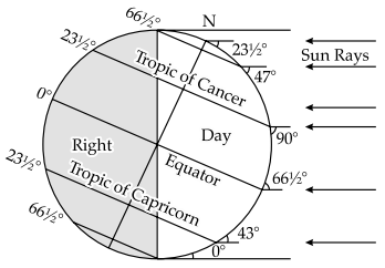
Effect of the tilt in the axis of rotation of the earth: If all the other conditions are favourable to a place on the earth’s surface then a longer duration of sunshine or a day of the length and shorter duration of night enable the place to receive more amount of insolation. The duration of sunshine or the length of the day varies at all places except at the equator due to the tilt in the inclination in the axis of rotation of the earth (661/2°) The length of a day is almost 12 hours on the equator because the light circle always divides the equator in two equal halves. The length of day increases pole wards with the northward march of the sun in the Northern Hemisphere while it decreases in the Southern Hemisphere at the time of summer solstice (21st June). In contrast, the length of day increases from the equator pole ward in the Southern Hemisphere but it decreases in the Northern Hemisphere at the time of winter solstice.
Question 26.
State the relationship between the gravitational forces and tides. 5
OR
Into how many categories can tides be classified on the basis of their height and frequency?
Answer:
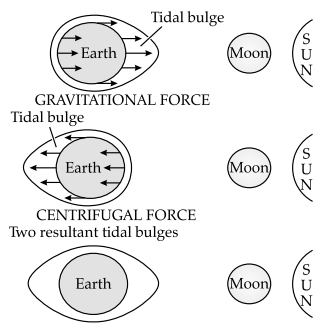
The moon’s gravitational pull to a great extent and to a lesser extent the sun’s gravitational pull, are the major causes for the occurrence of tides. Another factor is centrifugal force, which is the force that acts to counterbalance gravity. Together, the gravitational pull and the centrifugal force are responsible for creating the two major tidal bulges on the Earth.
On the side of the earth facing the moon, a tidal bulge occurs while on the opposite side though the gravitational attraction of the moon is less as it is farther away, the centrifugal force causes a tidal bulge on the other side. The ‘tide-generating’ force is the difference between these two forces; i.e. the gravitational attraction of the moon and the centrifugal force. On the surface of the earth, nearest the moon, the pull or the attractive force of the moon is greater than the centrifugal force and so there is a net force causing a bulge towards the moon.
On the opposite side of the earth, the attractive force is less, as it is farther away from the moon, the centrifugal force is dominant. Hence, there is a net force away from the moon. It creates a second bulge away from the moon. On the surface of the earth, the horizontal tide generating forces are more important than the vertical forces in generating the tidal bulges. The tidal bulges on wide continental shelves, have greater height. When tidal bulges hit the mid-oceanic islands they become low. The shape of bays and estuaries along a coastline can also magnify the intensity of tides.
OR
Tides may be grouped into various types based on their frequency of occurrence in one day or 24 hours or based on their height.
(a) Tides based on Frequency:
- Semi-diurnal tide: The most common tidal pattern, featuring two high tides and two low tides each day. The successive high or low tides are approximately of the same height.
- Diurnal tide: There is only one high tide and one low tide during each day. The successive high and low tides are approximately of the same height.
- Mixed tide: Tides having variations in height are known as mixed tides. These tides generally occur along the west coast of North America and on many islands of the Pacific Ocean.
(b) Tides based on the Sun, Moon and Earth Positions: The height of rising water (high tide) varies appreciably depending upon the position of the sun and moon with respect to the Earth. Spring tides and neap tides come under this category.
(i) Spring tides: The position of both the sun and the moon in relation to the earth has a direct bearing on tide height. When the sun, the moon and the earth are in a straight line, the height of the tide will be higher. These are called spring tides and they occur twice a month, one on the full moon period and another during new moon period.
(ii) Neap tides: Normally, there is a seven-day interval between the spring tides and neap tides. At this time the sun and moon are at right angles to each other and the forces of the sun and moon tend to counteract one another. The moon’s attraction, though more than twice as strong as the sun’s, is diminished by the counteracting force of the sun’s gravitational pull.
Question 27.
‘While the sun rises earlier in the east, say Nagaland and also sets earlier1, how do the watches at Kohima and
New Delhi show the same time? 5
OR
Write a note on the Islands of India.
Answer:
This is because India follows one standard time all over the country. There is a general understanding among the countries of the world to select the standard meridian in multiples of 7°30′ of longitude. That is why 82°30’ E has been selected as the ‘standard meridian’ of India. Indian Standard Time is ahead of Greenwich Mean Time by 5 hours and 30 minutes.
The actual local time of sunrise and sunset varies between Nagaland (Kohima) in the east and New Delhi in the west due to their east-west separation within the same time zone, the official time displayed on clocks in both places is the same because they both adhere to Indian Standard Time (IST).
Even though the sun rises and sets at different times in Nagaland and New Delhi, the clocks in both locations are synchronized to show the same time. This uniform timekeeping system across India is practical for coordinating activities, scheduling, and maintaining consistency in daily life and business operations throughout the country, despite the significant east-west extent of the country.
OR
India boasts two major island groups, one nestled in the Bay of Bengal and the other in the Arabian Sea. The Bay of Bengal group comprises approximately 572 islands and islets, sprawling across the latitudinal range of 6°N-14°N and the longitudinal range of 92°E-94°E. The principal subgroups are the Ritchie’s Archipelago and the Labyrinth Islands, divided into the Andaman in the north and the Nicobar in the south, separated by the Ten Degree Channel. These islands are considered elevated portions of submarine mountains, with some being of volcanic origin, including the lone active volcano, Barren Island, nestled in the Nicobar Islands.
The coastal areas feature coral deposits and picturesque beaches, while the islands experience convectional rainfall and host equatorial vegetation. On the other side, the Arabian Sea houses Lakshadweep and Minicoy, scattered between 8°N-12°N and 71°E-74°E, 280 km-480 km off the Kerala coast. These islands are primarily composed of coral deposits, with 36 islands in total, 11 of which are inhabited. Minicoy stands as the largest, spanning 453 sq. km. The archipelago is divided by the Ten Degree Channel, with Amini Island to the north and Cannanore Island to the south, showcasing unique storm beaches laden with unconsolidated pebbles, shingles, cobbles, and boulders along the eastern seaboard. These island groups are jewels in India’s geographical crown, offering diverse ecosystems and natural beauty.
Question 28.
What steps have been taken up to conserve forests? 5
OR
How can people’s participation be effective in conserving forests and wildlife?
Answer:
Steps that have been taken up to conserve forests are:
(i) Social forestry: It means the management and protection of forests and afforestation on barren lands with the purpose of helping in the environmental, social and rural development. The National Commission on Agriculture (1976) has classified social forestry into three categories:
(a) Urban forestry: It pertains to the raising and management of trees on public and privately owned lands in and around urban centres such as green belts, parks, roadside avenues, industrial and commercial green belts, etc.
(b) Rural forestry: It lays emphasis on promotion of agro-forestry and community- forestry.
(c) Agro-forestry: It is the raising of trees and agricultural crops on the same land inclusive of the waste patches. It combines forestry with agriculture, thus, altering the simultaneous production of food, fodder, fuel, timber and fruit.
(ii) Community forestry: It involves the raising of trees on public or community land such as the village pasture and temple land, roadside, canal bank, strips along railway lines and schools, etc. Community forestry programme aims at providing benefits to the community as a whole. Community forestry provides a means under which the people of landless classes can associate themselves in tree raising and thus, get those benefits that otherwise are restricted for landowners.
(iii) Farm forestry: It is a term applied to the process under which farmers grow trees for commercial and non-commercial purposes on their farmlands. Forest departments of various states distribute seedlings of trees free of cost to small and medium farmers. Several lands such as the margins of agricultural fields, grasslands and pastures, land around homes and cow sheds may be used for raising trees under non¬commercial farm forestry.
OR
People’s participation can be very effective in conserving forests and wildlife. It is the common people who harm and destroy the forests as well as the wildlife. They cut trees for shifting cultivation. They kill animals for entertainment. Therefore, in 1972, the Government of India passed the Wildlife Protection Act, whereby it is illegal to do hunting. Since then, the hunting and poaching cases have been reduced to a great extent. The two main objectives of the Act are: to provide protection to the endangered species listed in the schedule of the Act and to provide legal support to the conservation areas of the country classified as National parks, sanctuaries and closed areas.
This Act has been comprehensively amended in 1991, making punishments more stringent and has also made provisions for the protection of specified plant species and conservation of endangered species of wild animals. There are about 103 national parks and 535 wildlife sanctuaries covering an area of 15.67 million hectares in the country. These actions are taken by the government, but their implementation and maintenance depend on the participation and cooperation of the people.
Section – E
Question numbers 29 & 30 are Map based questions having 5 sub-parts each.
Question 29.
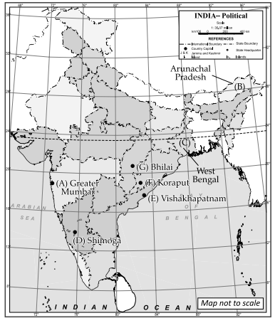
Identify and mark any five of the following features on the Political Outline map of India with the help of the given information: 5
(A) State with the highest level of urbanisation
(B) State with the lowest level of HDI
(C) Leading sugarcane-producing state
(D) A Software Technology Park
(E) An international airport
(F) An oil refinery
(G) City with an Important steel plant
Answer:
(A) Greater
(B) Arunachal Pradesh
(C) West Bengal
(D) Shimoga
(E) Vishakhapatnam
(F) Koraput
(G) Bhilai
Question 30.
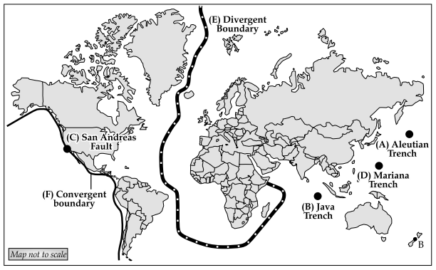
Below given are some of the major geographical features of the world. Locate and mark them based on the given information in the outline map of the world. Locate any five of the following. 5
(A) Aleutian trench
(B) Java trench
(C) San Andreas fault
(D) Mariana trench
(E) Draw one divergent boundary
(F) Draw one convergent boundary
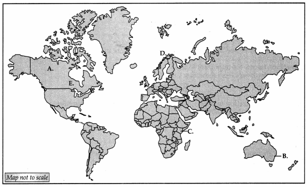
Answer: