Practicing Class 8 Social Science MCQ and Class 8 SST Part 2 Chapter 1 World Geography Some Glimpses MCQ Online Test with Answers daily helps in time management.
Class 8 World Geography Some Glimpses MCQ with Answers
MCQ on World Geography Some Glimpses Class 8
World Geography Some Glimpses MCQ Class 8
Question 1.
Which statement best explains why Earth appears predominantly blue when viewed from space?
(a) Most continents are covered with dense forests.
(b) Oceans cover about 71% of Earth’s surface and strongly influence its appearance.
(c) Earth’s atmosphere is naturally blue in color.
(d) Earth’s core reflects blue light.
Answer:
(b) Oceans cover about 71% of Earth’s surface and strongly influence its appearance.
Question 2.
In India, the Earth is personified as
(a) Terra
(b) Gaia
(c) Bhudevi or Vasudha
(d) Demeter
Answer:
(c) Bhudevi or Vasudha
Question 3.
The process of representing the Earth on a fiat surface is called
(a) Scale drawing
(b) Map projection
(c) Cartography
(d) Atlas making
Answer:
(b) Map projection
Question 4.
Which map projection keeps shapes and directions accurate but distorts size near the poles?
(a) Mercator Projection
(b) Robinson Projection
(c) Polar Projection
(d) Conical Projection
Answer:
(a) Mercator Projection
Question 5.
Which of the following ocean currents carry warm water from the equator toward the poles?
(a) Warm currents
(b) Cold currents
(c) SLow currents
(d) Deep currents
Answer:
(a) Warm currents

Question 6.
Which is the world’s largest coral reef system?
(a) Maldives Reef
(b) Caribbean Reef
(c) Great Barrier Reef
(d) Red Sea Reef
Answer:
(c) Great Barrier Reef
Question 7.
A narrow channel joining two seas or oceans is called:
(a) Bay
(b) Strait
(c) Gulf
(d) Canal
Answer:
(b) Strait
Question 8.
Which of the following ¡s the world’s highest and largest plateau?
(a) Deccan Plateau
(b) Colorado Plateau
(c) Tibetan Plateau
(d) Brazilian Plateau
Answer:
(c) Tibetan Plateau
Question 9.
The Gobi Desert is located In which of the following country?
(a) China and Mongolia
(b) Chile
(c) Australia
(d) Egypt
Answer:
(a) China and Mongolia
Question 10.
The Ural Mountains form the traditional natural boundary between which two continents?
(a) Asia and Africa
(b) Europe and Asia
(c) North America and South America
(d) Europe and Africa
Answer:
(b) Europe and Asia
Question 11.
The Andes Mountains have had a major influence on the development of South America mainly because they
(a) act as a major source of freshwater, minerals.
(b) form the natural boundary between Europe and Asia.
(c) receive the highest annual rainfall of any mountain range on Earth.
(d) consist entirely of extinct volcanic rocks with little economic importance.
Answer:
(b) form the natural boundary between Europe and Asia.
Question 12.
A prolonged reduction in the flow of the Nile River would most directly affect Egypt because the river
(a) is the country’s primary source of freshwater for irrigation, drinking water, and agriculture.
(b) provides access to the Pacific Ocean for international trade.
(c) supplies most of Africa’s mineral resources.
(d) forms the boundary between Africa and Asia.
Answer:
(a) is the country’s primary source of freshwater for irrigation, drinking water, and agriculture.
Question 13.
Scientists often use the Atacama Desert to test Instruments designed for Mars because it
(a) has extremely dry conditions and rocky terrain similar to parts of the Martian surface.
(b) experiences heavy snowfall throughout the year.
(c) contains the world’s largest tropical rainforest ecosystem.
(d) is covered by permanent glaciers and thick ice sheets.
Answer:
(a) has extremely dry conditions and rocky terrain similar to parts of the Martian surface.
Question 14.
Which scenario best demonstrates the economic importance of the Great Lakes to North America?
(a) serve as major shipping routes, provide drinking water to millions of people, and support trade, industry, and
commerce.
(b) Farmers depend on the Great Lakes to produce crude oil.
(c) The Great Lakes prevent volcanic eruptions across the continent.
(d) The lakes create the Sahara-like climate found in central North America.
Answer:
(a) serve as major shipping routes, provide drinking water to millions of people, and support trade, industry, and
commerce.
World Geography Some Glimpses Class 8 Assertion and Reason Questions
Question 1.
Assertion (A): The Mercator projection is useful for navigation and sea travel.
Reason (R): It accurately represents shapes and directions but distorts size near the poles.
Codes
(a) Both A and R are true, and R is the correct explanation of A.
(b) Both A and R are true, but R is not the correct explanation of A.
(c) A is true, but R is false.
(d) A is false, but R is true.
Answer:
(a) Both A and R are true, and R is the correct explanation of A.
Question 2.
Assertion (A): The Great Barrier Reef is called the rainforest of the sea.
Reason (R): Reefs provide only shelter for nearly one-quarter of all ocean species.
Codes
(a) Both A and R are true, and R is the correct explanation of A.
(b) Both A and R are true, but R is not the correct explanation of A.
(c) A is true, but R is false.
(d) A is false, but R is true.
Answer:
(c) A is true, but R is false.
Question 3.
Assertion (A): The European Plain has been the site of many historic battles.
Reason (R): Its flat land and fertile soil made it ideal for agriculture and settlements.
Codes
(a) Both A and R are true, and R is the correct explanation of A.
(b) Both A and R are true, but R is not the correct explanation of A.
(c) A is true, but R is false.
(d) A is false, but R is true.
Answer:
(b) Both A and R are true, but R is not the correct explanation of A.
Question 4.
Assertion (A): The Gobi Desert supports seasonal migration of herds.
Reason (R): Underground water helps plants grow in an otherwise harsh climate.
Codes
(a) Both A and R are true, and R is the correct explanation of A.
(b) Both A and R are true, but R is not the correct explanation of A.
(c) A is true, but R is false.
(d) A is false, but R is true.
Answer:
(b) Both A and R are true, but R is not the correct explanation of A.
Question 5.
Assertion (A): The Colorado Plateau is famous for the Grand Canyon.
Reason (R): It is mainly made of sedimentary rock uplifted by tectonic forces.
Codes
(a) Both A and R are true, and R is the correct explanation of A.
(b) Both A and R are true, but R is not the correct explanation of A.
(c) A is true, but R is false.
(d) A is false, but R is true.
Answer:
(a) Both A and R are true, and R is the correct explanation of A.
World Geography Some Glimpses Class 8 Fill in the Blanks
1. The seafloor has very deep, V-shaped valleys called ………………………. .
Answer:
ocean trenches
2. The deepest part of the Mariana Trench is called the ………………………. , which is over 11,000 metres below sea level.
Answer:
Challenger Deep
3. The world is generally divided into ……………………….. continents.
Answer:
Seven
4. Deserts receive less than …………………….. cm of rainfall each year.
Answer:
25
5. The ……………………… Steppes stretch for more than 8,000 kilometres from West to East and act as a global
carbon sink.
Answer:
Eurasian
6. The world’s largest coral reef system. located off northeastern Australia, is the ………………………. Reef.
Answer:
Great Barrier
7. The arid region in Australia inhabited by the Spinifex community is known as the ……………………….. Desert.
Answer:
Great Victoria
World Geography Some Glimpses Class 8 True or False
1. The Robinson Projection shows the correct shapes of countries but distorts their directions.
Answer:
False
2. The Suez Canal connects the Bay of Bengal with the Arabian Sea.
Answer:
False
3. The Gobi Desert experiences 8-9 months of sunshine but can have winters as cold as -30°C.
Answer:
True
4. The Alps are located in South America and are famous for skiing and alpine flowers like edelweiss.
Answer:
False
5. The Amazon River flows from the Andes to the Atlantic Ocean and supports almost 400 indigenous communities.
Answer:
True
6. The Colorado Plateau in North America is mainly composed of sedimentary rocks and is famous for the
Grand Canyon.
Answer:
True.
World Geography Some Glimpses Class 8 Match the Following
Question 1.
| List I (Oceans) | List II (Characteristics) |
| A. Atlantic Ocean | 1. It is the smallest and shallowest ocean and mostly covered with ice. |
| B. Indian Ocean | 2. It is the second-largest ocean and important for trade. |
| C. Arctic Ocean | 3. It has warm water and rich marine life. |
| D. Southern Ocean | 4. It is surrounded by Antarctica and is home to penguins and seals. |
Codes
A B C D
(a) 2 3 1 4
(b) 4 2 3 1
(c) 2 3 4 1
(d) 1 4 2 3
Answer:
(a) 2 3 1 4
| List I (Oceans) | List II (Characteristics) |
| A. Atlantic Ocean | 2. It is the second-largest ocean and important for trade. |
| B. Indian Ocean | 3. It has warm water and rich marine life. |
| C. Arctic Ocean | 1. It is the smallest and shallowest ocean and mostly covered with ice. |
| D. Southern Ocean | 4. It is surrounded by Antarctica and is home to penguins and seals. |
Question 2.
| List I (Types) | List II Examples |
| A. Bay | 1. Suez Canal |
| B. Strait | 2. Bay of Bengal |
| C. Canal | 3. Strait of Malacca |
| D. Gulf | 4. Persian Gulf |
Codes
A B C D
(a) 2 3 1 4
(b) 4 2 3 1
(c) 2 4 3 1
(d) 1 3 2 4
Answer:
(a) 2 3 1 4
| List I (Types) | List II Examples |
| A. Bay | 2. Bay of Bengal |
| B. Strait | 3. Strait of Malacca |
| C. Canal | 1. Suez Canal |
| D. Gulf | 4. Persian Gulf |
Question 3.
| List I (Landform) | List II (Characteristics) |
| A. Plateau | 1. High landform with narrow peaks |
| B. Mountain | 2. Large dry area with very little rainfall |
| C. Plain | 3. Elevated flat land, suitable for farming |
| D. Desert | 4. Extensive flat land ideal for agriculture |
Codes
A B C D
(a) 3 1 4 2
(b) 1 3 2 4
(c) 4 2 1 3
(d) 2 4 3 1
Answer:
(a) 3 1 4 2
| List I (Landform) | List II (Characteristics) |
| A. Plateau | 3. Elevated flat land, suitable for farming |
| B. Mountain | 1. High landform with narrow peaks |
| C. Plain | 4. Extensive flat land ideal for agriculture |
| D. Desert | 2. Large dry area with very little rainfall |
Question 4.
| List I (Continent) | List II (Feature) |
| A. South America | 1. Sahara Desert |
| B. North America | 2. Grand Canyon and Colorado Plateau |
| C. Africa | 3. Andes Mountains |
| D. Australia | 4. Great Victoria Desert |
Codes
A B C D
(a) 3 2 1 4
(b) 2 3 4 1
(c) 3 1 2 4
(d) 1 2 3 4
Answer:
(a) 3 2 1 4
| List I (Continent) | List II (Feature) |
| A. South America | 3. Andes Mountains |
| B. North America | 2. Grand Canyon and Colorado Plateau |
| C. Africa | 1. Sahara Desert |
| D. Australia | 4. Great Victoria Desert |
World Geography Some Glimpses Class 8 Picture based Questions
Question 1.
Observe the image showing a wide river surrounded by dense forest.
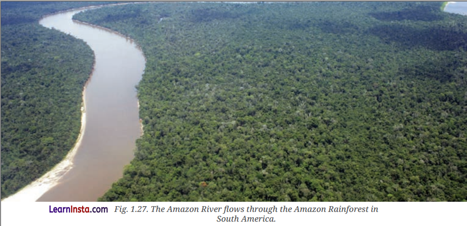
Which of the following conclusions can be drawn from the river and forest ecosystem shown?
(a) It is a river in a desert region with sparse vegetation.
(b) The river supports one of the world’s largest tropical rainforests with rich biodiversity.
(c) The river is located in North America and flows through a plateau.
(d) The river is highly seasonal and dries up for most of the year.
Answer:
(b) The river supports one of the world’s largest tropical rainforests with rich biodiversity.
Question 2.
Observe the image given below showing a high-altitude plateau with a deep canyon and a river flowing through it.
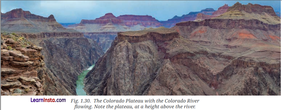
Based on the geographical features visible in the Image, which of the following conclusions can be most appropriately drawn?
(a) The river flows through a fertile delta suitable for agriculture.
(b) Tectonic uplift and erosion have created deep canyons in the plateau region.
(c) The area is primarily a desert with sparse vegetation.
(d) The river supports a dense tropical rainforest ecosystem.
Answer:
(b) Tectonic uplift and erosion have created deep canyons in the plateau region.
World Geography Some Glimpses Class 8 Case Based Questions
Question 1.
Read the passage given below and answer the following questions.
The Amazon River is the longest in South America and flows from the Andes Mountains in Peru and flows east
towards the Atlantic Ocean. The river basin, with all its tributaries, supports the Amazon Rainforest. Almost 400
indigenous communities reside ¡n the forest and play an important role in conserving the forest. Today, the Amazon is threatened by deforestation and climate change.
(i) The Amazon River flows East towards which ocean?
(a) Pacific Ocean
(b) Atlantic Ocean
(c) Indian Ocean
(d) Arctic Ocean
Answer:
(b) Atlantic Ocean
(ii) How does the Amazon River basin support the rainforest?
(a) By providing minerals for mining
(b) By supplying water and nutrients for the forest
(c) By preventing monsoon rains
(d) By forming deserts
Answer:
(b) By supplying water and nutrients for the forest
(iii) The Amazon Rainforest is home to approximately how many indigenous communities?
(a) 1oo
(b) 250
(c) 400
(d) 600
Answer:
(c) 400
Question 2.
Read the passage given below and answer the following questions.
The Atacama Desert is famous for stargazing, offering some of the clearest night skies, and its rocky, Mars-like landscape has even been used by NASA to test rovers. However, it has also become one of the world’s fastest-growing dumps for discarded clothes, caused by the rise of cheap fast fashion. The UN has called this waste problem ‘an environmental and social emergency’.
(i) Which situation best explains why a place known for scientific exploration is also facing a major environmental challenge?
(a) It receives heavy rainfall throughout the year.
(b) It has become a dumping ground for unwanted clothing due to fast fashion.
(c) It is losing tourists because of poor weather.
(d) It is covered by dense forests.
Answer:
(b) It has become a dumping ground for unwanted clothing due to fast fashion.
(ii) A researcher testing equipment in a landscape similar to another planet would most likely choose this desert because it is
(a) Filled with tropical vegetation.
(b) Surrounded by large rivers.
(c) Characterised by rocky terrain resembling Mars.
(d) Covered in permanent snow.
Answer:
(c) Characterised by rocky terrain resembling Mars.
(iii) Why has an international organisation described the clothing waste issue in this desert as an emergency?
(a) It has reduced the number of stars visible at night.
(b) It reflects serious environmental and social consequences linked to fast fashion.
(c) It has made the desert unsuitable for rover tesüng.
(d) It has increased rainfall in the region.
Answer:
(b) It reflects serious environmental and social consequences linked to fast fashion.