Teachers guide students to use Exploring Society India and Beyond Class 6 Solutions and Class 6 Social Science SST Chapter 1 Locating Places on the Earth Question Answer NCERT Solutions for quick learning.
Locating Places on the Earth Class 6 Question Answer Social Science Chapter 1
NCERT Class 6 Social Science SST Chapter 1 Locating Places on the Earth Questions and Answers Solutions
Locating Places on the Earth Class 6 Questions and Answers (In-Text)
The Big Questions (Page 7)
Question 1.
What is a map and how do we use it? What are its main components?
Answer:
Map is a representation or drawing of an area of the Earth on a fiat surface whether small or large – say of a district or village or very large area like India or even the world at a specific scale.
- One map contains many facts.
- Collection of maps is called an Atlas.
Maps can be used to represent details of areas and features of the Earth.
Examples:
- Physical Maps: Physical features of the Earth such as mountains, oceans, rivers, plains and plateaus
- Political Maps: Political division of the Earth – countries, states, boundaries, capital, cities, villages etc.
- Thematic Maps: Specific information like rainfall, forests, minerals, roads, industries, population density etc.
- The main components of maps are:
- Distance
- direction and
- symbols.
![]()
Question 2.
What are coordinates? How can latitude and longitude be used to mark any location on the Earth?
Answer:
- Coordinates are two numbers or sometimes a letter and a number (Example: Chess board) that locate a specific point on a grid.
- On a map latitudes and longitudes are referred to ’ as two coordinates of a place. They provide systematic network of lines (grid lines) upon which the position of various surface features of the Earth can be represented, located and identified.
- Latitudes are horizontal lines that measure distance North and South of the equator. Longitudes are vertical lines that measure East or West of the Prime Meridian. But there exists only one point where they intersect. By combining these two coordinates and identifying the point of intersection of latitudes and longitudes one can mark and locate any location on the earth.
Question 3.
How are local time and standard time related to longitude?
Answer:
Longitudes are related to local time and standard time as they help us to calculate time.
- Time is measured by the movement of the earth.
- The earth spins on its axis West to East making a full turn of 360° in 24 hours (rotation).
- This means 15° per hour (15° × 24 = 360°) or say 4 minutes for one degree of longitude.
- Accordingly the earth has been divided into 24 time zones of one hour each.
- Moving eastwards from the Prime Meridian we get 12 time zones, 15° apart example: 0°, 15°E, 30°E etc. and likewise westwards (example 0°, 15°W, 30°W).
- Each place has different time of sunrise and sunset.
- Places east of Prime Meridian/ Greenwich Meridian experience sunrise (day) earlier than places lying west of the Meridian.
Local time of a place is based on the longitude of that place i.e. local time varies when places are situated on different meridians.
- To solve confusion in a country every country fixes its central meridian, passing through them as the standard meridian. The standard times are organised in time zones of 15° or 7.5°.
- The local time of the meridian is considered standard for the whole country. It is called standard time.
- Example: In India the longitude of 82 ½° E is treated as the standard meridian. The local time of the Meridian is known as Indian Standard Time (IST).
- – Through an international, agreement, the local time of all places is linked to the Greenwich Mean Time. The IST is 5 hours 30 minutes ahead of GMT.
- Both local and standard time are related to longitude.
Local time refers to the time of a place as defined by the apparent motion of the Sun. Standard time is agreed time of places along the same meridian established by law in the same country.
While local time changes continuously as longitude changes, the standard time stays-the same for a specific nation.
Let’s Explore
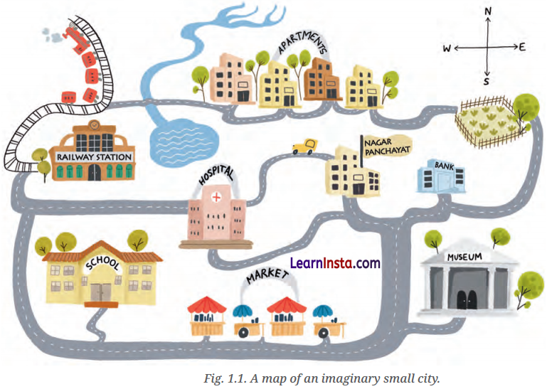
1. On the above map: (Page 9)
(i) Mark the hospital.
Answer:
Do it yourself.
(ii) What is the meaning of the blue-coloured areas?
Answer:
The blue-coloured areas on the map represents water.
(iii) Which is farther away from the railway station-the school, the Nagar Panchayat or the public garden?
Answer:
Do it yourself.
![]()
Question 2.
As a class activity, form groups of three or four students each. Let each group try to draw a map of your school and some of the streets or roads that lead to it, and a few neighbouring buildings. At the end, compare all the maps and discuss. (Page 9)
Answer:
Do it yourself.
Question 3.
Consider the map of the small city again. Identify the correct and incorrect statements in the list below.
(a) The market is North of the hospital.
Answer:
Incorrect
(b) The museum is South-East of the bank.
Answer:
Incorrect
(c) The railway station is North-West of the hospital.
Answer:
Correct
(d) The lake is North-West of the apartment blocks.
Answer:
Correct
(ii) The museum is southeast of the bank.
Answer:
Correct
(iii) The railway station is northwest of the hospital.
Answer:
Correct
(iv) The lake is northwest of the apartment blocks.
Answer:
Incorrect
![]()
Question 4.
Taking your school as the starting point, do you know approximately in which cardinal direction your home is located? Discuss with your teacher and your parents. (Page 11)
Answer:
Do it yourself.
Question 5.
Draw a simple map of a school’s playground. Let us assume it is a rectangle, 40 m in length and 30 m in width. Draw it precisely with your ruler on a scale of 1 cm = 10 m. (Page 10)
Answer:
Do it yourself.
Question 6.
Now measure the diagonal of the rectangle., How many centimetres do you get? Using the scale, calculate the real length of the playground’s diagonal, in metres. (Page 10)
Answer:
Do it yourself.
Question 7.
Draw a rough map of your locality or your village, including your home, school and a few other important landmarks. Show the cardinal directions and use a few of the symbols shown in Fig. 1.2 (on page 12) to mark some important features. (Page 11)
Answer:
Do it yourself.
Question 8.
Using the same terms (as given in page 13), write down your move if you play black and respond with the same move. (Page 13)
Answer:
Do it yourself.
![]()
Question 9.
If the globe or atlas in your class has wellmarked latitudes and longitudes, try to note down approximate values for the latitude and longitude of (page 18) (1) Mumbai, (2) Kolkata, (3) Singapore, (4) Paris. (Page 17)
Answer:
Here are the approximate values for the latitude and longitude of the specified locations:
(i) Mumbai, India
→ Latitude: 19.0760° N
→ Longitude: 72.8777° E
(ii) Kolkata, India
→ Latitude: 22.5726° N
→ Longitude: 88.3639° E
(iii) Singapore
→ Latitude: 1.3521° N
→ Longitude: 103.8198° E
(iv) Paris, France
→ Latitude: 48.8566° N
→ Longitude: 2.3522° E
Question 10.
Two friends, one sitting in Porbandar (Gujarat) and the other in Tinsukia (Assam), are speaking on the phone late afternoon. The latter remarks that the sun has set in Assam and it’s now dark. The former is surprised and says, “But it’s still full daylight here!” Explain why. And, as a class activity, calculate the difference in local time between those two cities. (Hint: for now, consider the difference in longitude between Porbandar and Tinsukia to be 30°; later, you can find out the precise value.) (Page 21)
Answer:
The difference in local time between Porbandar (Gujarat) and Tinsukia (Assam) is due to their different longitudes. As the Earth rotates from west to east, different locations experience sunrise and sunset at different times. When it is evening in one place, it can still be daytime in another location further west.
Since Tinsukia is east of Porbandar, the sun will set earlier in Tinsukia than in Porbandar. This is why Tinsukia is already dark while Porbandar still has daylight.
Calculation:
Difference in Longitude: The given difference in longitude between Porbandar and Tinsukia is 30°.
Time Differ ence Calculation: The Earth rotates 360° in 24 hours, so it rotates 15° per hour (360° ÷ 24 hours). The time differencecan be calculated by dividing the longitude difference by 15° per hour.
Time Difference = 15° per hour ÷ 30° = 2 hours So, the local time in Porbandar is 2 hours ahead of the local time in Tinsukia. When it’s dark in Tinsukia, it’s still daylight in Porbandar.
![]()
Question 11.
Return to the two friends sitting in Gujarat and Assam. Use this example to explain the difference between local time and standard time. (Page 21)
Answer:
The difference between local time and standard time are as follows:
Local time is the time based on the position of the
sun in a specific location. It changes with longitude because the Earth rotates 15° every hour, causing sunrise and sunset to occur at different times in different places.
Example with Porbandar and Tinsukia:
Longitude difference: 30°
Time difference: 2 hours (since 30° ÷ 15° per hour = 2 hours)
If it’s 6:00 PM in Tinsukia, it will be 8:00 PM in Porbandar due to the 2 hour time difference.
Standard time is a uniform time used across a larger region or country to make timekeeping consistent. Time zones are used to establish standard times that do not change with every degree of longitude within the zone.
Time Zones and Standard Time:
Porbandar and Tinsukia might be in different time zones, with Porbandar possibly following a standard time that is 2 hours ahead of Tinsukia’s time.
Standard time zones help avoid the confusion of local time differences by providing a consistent reference across large areas.
Class 6 SST Locating Places on The Earth Question Answer (Exercise)
Question 1.
Returning to page 10 and to Fig. 5.2 in Chapter 5 of this textbook, taking the scale to be 2.5 cm = 500 km , calculate the real distance from the estuary of the Narmada River to the estuary of the Ganga river. (Hint: round off your measurement on the map to an easy number.)
Answer:
To calculate the real distance from the estuary of the Narmada River to the estuary of the Ganga River using the given scale (2.5 cm = 500 km), follow these steps:
Use a ruler to measure the distance between the two points (Narmada River estuary and Ganga River estuary) on the map. Suppose the distance measures approximately 12 cm .
Given that 2.5 cm on the map represents 500 km in reality, you can set up a proportion to find the actual distance.
Distance on map (cm)= Real distance (km)
2.5 cm = 500 km
12 cm = x km
= 12 cm × \(\frac{500 \mathrm{~km}}{2.5 \mathrm{~cm}}\)
x = \(\frac{6000 \mathrm{~km}}{2.5 \mathrm{~cm}}\)
x = 2400 km
Therefore, the real distance from the estuary of the Narmada River to the estuary of the Ganga River is approximately 2400 km.
![]()
Question 2.
Why is it 5:30 pm in India when it is 12 pm or noon in London?
Answer:
India is 5 hours and 30 minutes ahead of London because of the difference in time zones. The Earth is divided into 24 time zones and each time zone is 1 hour apart from its neighbouring time zones. Since India is to the East of London, it is ahead of time. So, when it is 12:00 PM (noon) in London, it is already 5:30 PM in India.
Question 3.
Why do we need symbols and colours in the map?
Answer:
We use symbo/s and colours in the map due to following reasons:
It is not possible to draw, on a map, the actual shape and size of different features such as buildings, roads, bridges, trees, railway lines or a well. So, they are shown by using certain letters, shades, colours, pictures and lines. These symbols give a lot of information in a limited space.
Colours play an essential role in a map as they help to distinguish and identify different features, such as landforms, bodies of water, and political boundaries. For example, blue colour is used to depict water bodies, green is used to indicate forests or vegetation, and brown is used to show mountainous areas, etc.
Question 4.
Delhi’s and Bengaluru’s latitudes are 29° N and 13° N; their longitudes are almost the same, 77° E. How much will be the difference in local time between the two cities?
Answer:
There will be no difference in the local times of the two cities. The difference in time depends on the difference in longitudes. If Delhi and Bengaluru are almost on the same longitude there will be no difference in local time between the two cities.
![]()
Question 5.
Mark the following statements as true or false; explain your answers with a sentence or two.
(i) All parallels of latitude have the same length.
(ii) The length of a meridian of longitude is half of that of the Equator.
(iii) The South Pole has a latitude of 90° S.
(iv) In Assam, the local time and the IST are identical.
(v) Lines separating the time, zones are identical with meridians of longitude.
(vi) The Equator is also a parallel of latitude.
Answers:
(i) False (Explanation: Parallels of latitude vary in length. The Equator is the longest parallel, while those closer to the poles are shorter).
(ii) False (Explanation: The length of a meridian of longitude is the same as the length of the Equator. Both run from pole to pole and are equal in length).
(iii) True (Explanation: The South Pole is located at 90 degrees south of the Equator, making its latitude 90° S).
(iv) True (Explanation: Assam, like the rest of India, uses Indian Standard Time (IST), so the local time and IST are the same.)
(v) False (Explanation: While time zones are based on meridians of longitude, the lines separating them are not always straight and can be adjusted to follow country borders).
(vi) True (Explanation: The Equator is the most important parallel of latitude, located at 0° latitude).
Activities
1. Find out what you have in the eight directions from your home or school.
Answer:
Do it yourself
2. What is the difference between local time and standard time? Discuss it in groups, with each group writing an answer in 100 to 150 words. Compare the answers.
Answer:
Do it yourself.
3. Solve the crossword below.
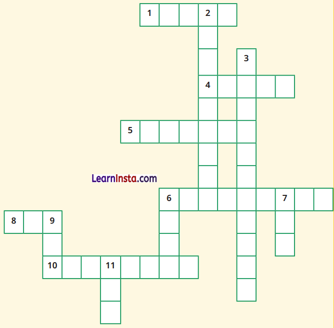
Across :
1. Let’s you squeeze a huge area into your map
4. A convenient sphere
5. The longest parallel of latitude
6. The place the Prime Meridian is attached to
8. So convenient to find your way
10. A measure of the distance from the Equator
Down :
2. A measure of the distance from the Prime Meridian
3. These two together allow us to locate a place
6. What latitudes and longitudes together create
7. The time we all follow in India
9. These two are poles apart
11. An abbreviation for a line across which the day and date change
Answers:
Across:
1. Scale
4. Globe
5. Equator
6. Greenwich
8. Map
10. Latitude
Down:
2. Longitude
3. Coordinates
6. Grid
7. IST
9. Poles
11. IDL