Students can access the CBSE Sample Papers for Class 12 Geography with Solutions and marking scheme Set 7 will help students in understanding the difficulty level of the exam.
CBSE Sample Papers for Class 12 Geography Set 7 with Solutions
Time : 3 Hours
Maximum Marks: 70
General Instructions :
- This question paper contains 30 questions. All questions are compulsory.
- This question paper is divided into five sections. Sections A, B, C, D, and E.
- Section A – Question number 1 to 17 are Multiple Choice type questions carrying 1 mark each.
- Section B – Question number 18 and 19 are Source-based questions carrying 3 marks each.
- Section C – Question number 20 to 23 are Short Answer type questions carrying 3 marks each. Answer to these questions shall be written in 80 to 100 words.
- Section D – Question number 24 to 28 are Long Answer type questions carrying 5 marks each. Answer to these questions shall be written in 120 to 150 words.
- Section E – Question number 29 and 30 are Map-based questions.
Section-A (17×1=17 Marks)
Multiple Choice Questions
Question 1.
Consider the following statements and choose the correct answer with the help of given options. [1]
1. Assertion: The development of railways in the nineteenth century, had a great impact on various sectors in the USA.
2. Reason: It opened up continental interiors for commercial grain farming, mining and manufacturing in the USA.
(a) Both the statements are true, statement 2 does not explain statement 1 correctly.
(b) Both the statements are true and statement 2 correctly explains the statement 1.
(c) Both statements 1 and 2 are wrong.
(d) Statement 1 is true and statement 2 is incorrect.
Answer:
(b) Both the statements are true and statement 2 correctly explains the statement 1.
Question 2.
Match Column I (Period) with Column II (Approaches) and choose the correct option with the help of given Codes. [1]
| Column I | Column II |
| I. Early Colonial period | 1. Areal differentiation |
| II. Later Colonial period | 2. Exploration and description |
| III. 1930s through the Inter-War period | 3. Spatial organisation |
| IV. Late 1950s to the late 1960s | 4. Regional analysis |
I II III IV
(a) 2 3 4 1
(b) 3 4 2 1
(c) 2 4 1 3
(d) 1 3 2 4
Answer:
(c) 2 4 1 3
Question 3.
Which of the following is not an approach in human geography? [1]
(a) Exploration and description
(b) Areal differentiation
(c) Spatial organisation
(d) Quantitative revolution
Answer:
(d) Quantitative revolution
![]()
Question 4.
Industries producing breads and biscuits, tea, soaps and toiletries, paper for writing, televisions, etc., are ___________. [1]
(a) secondary industries
(b) consumer based industries
(c) consumer
(d) traditional industries
Answer:
(b) consumer based industries
Question 5.
Arrange the following carriers of load from the earliest to the modern. [1]
i. Carts and wagons
ii. Palanquin
iii. Steam engine
iv. Humans
Choose the correct option.
(a) i, iv, iii, ii
(b) iv, ii, i, iii
(c) ii, iii, iv, i
(d) iii, i,iv,ii
Answer:
(b) iv, ii, i, iii
Question 6.
Which of the following is not correctly matched? [1]
| (a) Medical Geography | Epidemology |
| (b) Geography of Resources | Resource Economics |
| (c) Gender Geography | Women’s Studies |
| (d) Geography of Well-being | Political Studies |
| Answer: (d) Geography of well-being |
Political Studies |
Question 7.
Which one of the following is not a type of degraded land caused by natural as well as human factors? [1]
(a) Coastal sands
(b) Marshy areas
(c) Waterlogged areas
(d) Land affected by salinity
Answer:
(a) Coastal sands
Question 8.
Solid wastes cause health hazards through: [1]
(a) creation of obnoxious smell,
(b) harbouring of flies and rodents
(c) carriers of diseases like typhoid, diphtheria, diarrhoea, malaria and cholera
(d) All of the above
Answer:
(d) All of the above
Question 9.
Name the newly developed port of India which developed to revive Mumbai port: [1]
(a) Kandla
(b) Jawaharlal Nehru
(c) Chennai
(d) Kolkata
Answer:
(b) Jawaharlal Nehru
![]()
Question 10.
Which among the following is correct about the first Asia’s Cross country pipeline? [1]
(a) Assam to Baruni in Bihar
(b) Assam to Kanpur
(c) Baruni to Kanpur
(d) Ankleshwar to Koyali
Answer:
(a) Assam to Baruni in Bihar
Question 11.
“The assessment, efficient use and conservation of water are necessary to ensure development”. Identify the values enshrined in the statement. [1]
I. Sustainable development
II. Social awareness
III. Environmental destruction
(a) Only I
(b) Only II
(c) Only III
(d) Both I and II
Answer:
(d) Both I and II
Question 12.
Current follow land is land which left uncultivated for period of: [1]
(a) More than 5 years
(b) 3 to 5 years
(c) 2 to 5 years
(d) 1 or less than 1 year
Answer:
(d) 1 or less than 1 year
Question 13.
Which one of the following Railways is considered an engineering marvel? [1]
(a) Konkan Railway
(b) South Western Railway
(c) Central Railway
(d) North Eastern Railway
Answer:
(a) Konkan Railway
![]()
Question 14.
Which one of the following places is famous for production of railways coaches? [1]
(a) Nasik
(b) Kapurthala
(c) Kanpur
(d) Kochi
Answer:
(b) Kapurthala
Read the following case study and answer questions no. 15 to 17.
Cyberspace: Internet
Cyberspace is the world of electronic computerised space. It is encompassed by the Internet such as the World Wide Web (www). In simple words, it is the electronic digital world for communicating or accessing information over computer networks without physical movement of the sender and the receiver. It is also referred to as the Internet. Cyberspace exists everywhere. It may be in an office, sailing boat, flying plane and virtually anywhere. The speed at which this electronic network has spread is unprecedented in human history. There were less than 50 million Internet users in 1995, about 400 million in 2000 A.D. and over two billion in 2010. In the last few years there has been a shift among global users from USA to the developing countries. The percentage share of USA has dropped from 66 in 1995 to only 25 in 2005. Now the majority of the world’s
users are in USA., UK., Germany, Japan, China and India. As billions use the Internet each year, cyberspace will expand the contemporary economic and social space of humans through e-mail, e-commerce, e-leaming and e-govemance. Internet, together with fax, television and radio, will be accessible to more and more people cutting across place and time. It is these modem communication systems, more than transportation that has made the concept of global village a reality.
Question 15.
Which of these statements is/are true for cyberspace? [1]
(a) It is the world of electronic computerised space.
(b) It is encompassed by the Internet such as the World Wide Web (www).
(c) It is the electronic digital world for communicating or accessing information over computer networks.
(d) All of the above
Answer:
(d) All of the above
Question 16.
‘In the last few years there has been a shift among global users from U.S.A. to the developing countries.’ [1]
In which developed/developing countries do you now find majority of the world’s Internet users?
Choose the correct set of countries from the options below.
(a) USA, China, France, India, Bangladesh
(b) USA, UK, Germany, Japan, China and India
(c) UK, Germany, Japan, Pakistan and India
(d) USA, Germany, Japan, Bangladesh and India
Answer:
(b) USA, UK, Germany, Japan, China and India
![]()
Question 17.
How many Internet users were there by 2010, at the global level? [1]
(a) Less than 50 million users
(b) About 400 million users
(c) Around one billion
(d) Over two billion
Answer:
(d) Over two billion
Section-B (2×3=6 Marks)
Source-based questions
Question 18.
Read the Case Study given below carefully and answer the questions that follow: [3]
At Singareni, Canaries to miners’ rescue
Singareni collieries, the country’s premier coal production company, still uses canaries to detect the presence of deadly carbon monoxide in underground mines. Miners collapse and often die even if small quantities of the highly poisonous CO are present in the air. Though, miners speak lovingly of the canaries, the underground experience is not at all pleasant for the birds. When lowered into mines with CO presence, the birds show distress symptoms such as ruffling of feathers, pronounced chirping and loss of life. These reactions occur even if 0.15 per cent of CO is present in the air. If the content is 0.3 percent the bird shows immediate distress and falls off its perch in two to three minutes. A cage of birds is a good indicator in air containing more than 0.15 per cent CO, said a coal miner. The sophisticated hand held CO detectors introduced by the company can detect CO concentrations from as low as 10 ppm to as high as 1,000 ppm. But despite this, the miners trust the birds, who have saved the lives of several of their predecessors. (Deccan Chronicle, 26.08.2006)
(a) Which premier coal production company still uses canaries to detect the presence of deadly carbon monoxide in underground mines?
(b) Why the underground experience is not at all pleasant for the birds.
(c) What is the amount that sophisticated hand held CO detectors can measure CO concentrations?
Answer:
(a) Singareni collieries.
(b) When lowered into mines with CO presence, the birds show distress symptoms such as ruffling of feathers, pronounced chirping and loss of life.
(c) The sophisticated hand held CO detectors introduced by the company can detect CO concentrations from as low as 10 ppm to as high as 1,000 ppm.
![]()
Question 19.
Study the given data and answer the following questions: [3]
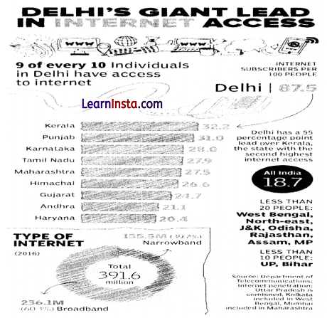
(a) Why does Delhi tops the list of internet users in India?
(c) What is ‘Digital India’?
(b) Where does India stand in the number of internet subscribers, globally?
Answer:
(a) Delhi is the home to the largest internet population in India because Delhi has the highest rate of urbanisation (in union territory) in India.
(b) India ranks at the 2nd position in the number of internet subscribers across the world with 833.71 million users, which are less than China only.
(c) Digital India is a flagship campaign launched by the Government of India with a wish to transform India into a digitally empowered economy by making electronically available and improved online infrastructure and internet connectivity.
Section-C (4×3=12 Marks)
Short Answer type questions
Question 20.
(A) Write a short note on pipelines. [3]
OR
(B) List the various steps for better urban transport solution.
Answer:
(A) Pipelines are used extensively to transport liquids and gases such as water, petroleum and natural gas for an uninterrupted flow. Water supplied through pipelines is familiar to all. Cooking gas or LPG is supplied through pipelines in many parts of the world. Pipelines can also be used to transport liquidities coal. In New Zealand, milk is being supplied through pipelines from farms to factories.
OR
(B) For better urban transport system, the following can be adopted:
- Mass rapid transit (MRT)
- Improved public bus service
- Expressways
- Carpool
- Higher parking fees
- Government measures like odd-even car system to regulate traffic flow.
![]()
Question 21.
What are three characteristics of last stage of Demographic Transition Theory? [3]
Answer:
In the last stage of demographic transition theory, both fertility and mortality decline considerably. Its characteristics features are as follows:
- It is the stage of stable population.
- It is also the indicator of slow population growth.
- It also indicates that humans are extremely flexible and are able to adjust their fertility.
Question 22.
(A) What factors are responsible for different types of rural settlements in India? [3]
OR
(B) Give two characteristics of urban settlements in India. How are cities connected to rural settlements?
Answer:
(A) Different types of rural settlements in India are caused by a variety of circumstances and environments.
They are as follows:
- Physical features- nature of terrain, altitude, climate and availability of water.
- Cultural and ethnic factors- social structure, caste and religion.
- Security factors- defence against thefts and robberies.
OR
(B) Urban settlements are often smaller and more compact, and they perform a wide range of nonagricultural, commercial, and administrative functions. Cities and the rural areas that surround them are functionally connected. The exchange of commodities and services for food and raw resources takes place either directly or through market towns and cities.
Question 23.
“The Mumbai High is one of the major causes of marine pollution in the Arabian Sea.” Examine with examples. [3]
Answer:
The Mumbai High, India’s top oil and gas producing field, located off the coast of Mumbai, is one of the main causes of marine pollution in the Arabian Sea. The oil and gas leaks from the field and the pipelines adversely affect the marine life of the sea. Accidents and devastating incidents of fire raise the temperature of the sea causing harm to the marine ecology.
Section-D (5×5=25 Marks)
Long Answer Type Questions
Question 24.
Define the term ‘mixed farming’. Explain any four characteristics of mixed farming practiced in the world. [5]
Answer:
Mixed farming is a type of agricultural farming in which farmers cultivate crops and also rear animals on the farm.
The four characteristics of mixed farming are as follows:
1. This kind of agriculture is practiced in developed parts of the world viz. North-Western Europe, Eastern-North America and parts of Eurasia.
2. Mixed farms are moderate in size and usually, the crops associated with it are wheat, barley, rye, maize, fodder and root crops. Fodder crops are an important component of mixed farming.
3. The rotation and inter-cropping play an important role in maintaining soil fertility, chemical fertilizers and green manures are used extensively to achieve more output.
4. Equal emphasis is laid on crop cultivation and animal husbandry so that farm animals like cattle, sheep, pigs, and poultry provide additional income along with crops.
![]()
Question 25.
(A) “International trade has shown detrimental effects on the under developed and developing economies”. Do you agree or not? Justify your stand. [5]
OR
(B) Categories the ports on the basis of the specialised functions they play.
Answer:
(A) International trade can prove to be detrimental to nations in the following ways:
- The underdeveloped and developing nation depends upon the developed nations because they specialisation in the production process.
- International trade makes the rich countries richer and leads to uneven global development.
- The third world countries commonly become the raw material supplier to feed the industries of developed nations. For e.g., colonies of European countries.
- The underdeveloped nations to complete the global trade, increases their production activities by extracting the natural resources unsustainability.
- Organisations in such countries are geared only towards profit making, and environmental and health concerns are not addressed, then it could lead to serious implications in the future.
OR
(B) Types of port on the basis of specialised functions:
- Oil Ports: These ports deal in the processing and shipping of oil. Some of these are tanker ports and some are refinery ports. Maracaibo in Venezuela, Esskhira in Tunisia, Tripoli in Lebanon are tanker ports. Abadan on the Gulf of Persia is a refinery port.
- Ports of Call: These are the ports which originally developed as calling points on main sea routes where ships used to anchor for refuelling, watering and taking food items. Later on, they developed into commercial ports. Aden, Honolulu and Singapore are good examples.
- Packet Station: These are also known as ferry ports. These packet stations are exclusively concerned with the transportation of passengers and mail across water bodies covering short distances. These stations occur in pairs located in such a way that they face each other across the water body, e.g. Dover in England and Calais in France across the English Channel.
- Entrepot Ports: These are collection centres where the goods are brought from different countries for export. Singapore is an entrepot for Asia. Rotterdam for Europe, and Copenhagen for the Baltic region.
- Naval Ports: These are ports which have only strategic importance. These ports serve warships and have repair workshops for them. Kochi and Karwar are examples of such ports in India.
Question 26.
(A) With respect to developed and developing notion, what do yo mean population change? [5]
OR
(B) Describe the basic concept which are given below:
(a) Growth of population
(b)Growth rate of population
(c) Natural growth of population
(d)Positive growth of population
(e) Negative growth of population
Answer:
(A) Difference in the birth, death and migration of an area between two points of time leads to the size of population thus resulting in population.
Population growth is low in developed countries than the developing countries. Population growth and economic developments are negatively correlated.
In a developing country with a large population, even a small annual growth rate will lead to a huge change in population. Even if the growth rate continues to decline, the total population increases every year.
Presently the population of the world is 7.033 billion and is increasing at an alarming rate with more than 8 cores being added every year.
Though the developed nations have stabilised their growth, the developing nations are yet to reach that target. The population in the developing nations is bound to increase in the coming years as the proportion of their youthful population is high.
OR
(B) Some basic differences among the above-mentioned terms may be enumerated as follows:
1. Growth of population: Change of population in particular area between two points of time is known as growth of population, i.e., difference is population on decadal basis in absolute number of population for an area/region/country.
2. Growth rate of population: This is the change of population expressed in percentage.
3. Natural growth of population: This is the population increased by difference between births and deaths in a particular region between two points of time i.e.
Natural growth = Births- Deaths.
Actual growth of population: this is Births- deaths + in migration- Out migration.
4. Positive growth of population: This happens when the birth rate is more than the death rate between two points of time or when people from other countries migrate percentage to a region.
5. Negative growth of population: If the population decreases between two points of time it is known as negative growth of population. It occurs when the birth rate falls below the death rate or people migrate to other countries.
![]()
Question 27.
(A) Why is the water quality in the plains the worst? [5]
OR
(B) The depleting water resources may lead to social conflicts and disputes. Elaborate it with suitable examples?
Answer:
(A) 1. Rapid urbanisation in plain areas is widening the gap, since infrastructure planning is not keeping as the pace with growth in housing.
2. There is poor infrastructure available in cities and towns located near rivers.
3. Discharge of toxic elements from industries and landfills and diffused sources of pollution like fertilisers and pesticides and their increased use over the years has resulted in high level of contamination of groundwater with the level of nitrate exceeding the permissible limit in more than 50% district’s of India.
4. Failure of several national programs runs by the Centre for river conservation, wet land preservation and water quality monitoring in plain areas.
5. Deforestation, unscientific methods of agriculture, lack of sanitation has also lead to pollution of groundwater, making it unfit for consumption
OR
(B) It can be said with some certainty that due to the depletion of water resources, societies will witness demographic transition, a geographical shift of population, technological advancement, degradation of the environment, and water scarcity. Water scarcity is possible to pose the greatest challenge on account of its increased demand ,coupled with shrinking supplies due to over utilisation and pollution.
Water is a cyclic resource with abundant supplies on the globe. Approximately, 71% of the earth’s surface is covered with it but freshwater constitutes only about 3% of the total water. In fact, a very small proportion of freshwater is effectively available for human use. The availability of freshwater varies over space and time. The tensions and disputes on sharing and control of this scarce resource are becoming contested issues among communities, regions, and states.
It is the scarcity of water that has caused longstanding disputes between the state of Karnataka and TamilNadu over sharing of waters of the Kaveri River. Sharing of water of Brahmaputra has always been a cause of conflict between India and Bangladesh. Much to India’s dislike and concern China is planning to build a dam on river Brahmaputra.
![]()
Question 28.
Discuss the four phases of population growth in India. [5]
Answer:
The four phases of population growth in India are as follows:
1. Period of Stagnant Phase of Population Growth: During the decades 1901-1921, very low and negative growth rate was recorded during 1911-1921, high birth and death rate in this period, poor health and medical services, illiteracy, inefficient distribution system of food and other basic necessities largely responsible.
2. Period of Steady of Population Growth: During the decades of 1921-1951, overall improvement in health and sanitation throughout the country brought down the mortality rate, better transport and communication system improved the distribution system, high crude birth rate.
3. Period of Population Explosion: During the decades 1951-1981, caused by a rapid fall in the mortality rate besides the high fertility rate of population, average annual growth rate as high as 2.2%, developmental activities through a centralized planning process and economy improved the living condition of people, a high natural increase and higher growth rate, increased international in-migration bringing in Tibetans, Bangladeshis, Nepalese and Pakistanis.
4. Period of High Population Growth with definite signs of slowing down: From 1981 to the present, growth rate has been slowing down gradually due to the downward trend of crude birth rate, increase in the mean age at marriage, improved quality of life, education of females in the country.
Section-E (2×5=10 Marks)
Map-based questions
Question 29.
On the given political map of the world, the following seven features are shown. Identify any five of these features and write their correct names on the lines marked near each feature. [5]
A. An important Iron and steel centre in Japan.
B. Hub for technology companies in USA.
C. An important Iron and steel centre in USA.
D. Identify the Sea in which Volga River drain and this river provide waterway upto 11,200 km.
E. Identify the region that connect interior part of USA through Mississippi-Ohio waterway.
F. Western terminal of Trans-Siberian railway.
G. Identify the city where the headquarter of EU is located
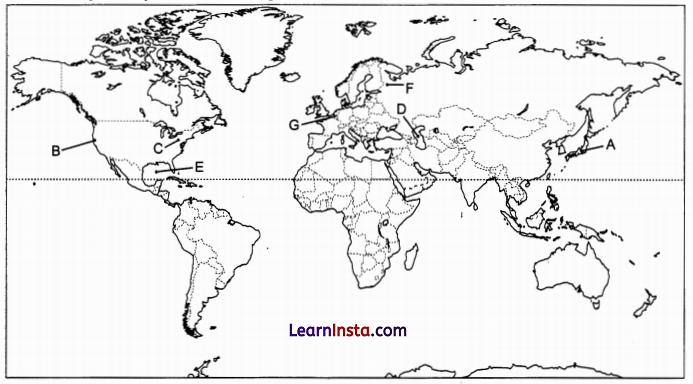
Answer:
A. Tokyo
B. Silicon valley
C. Pittsburgh
D. Caspian Sea
E. Gulf of Mexico
F. St. Petersburg
G. Brussels
![]()
Question 30.
On the given political map of India, locate and label any five of the following with appropriate symbols: [5]
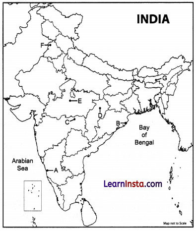
A. Iron mine in Karnataka.
B. Important iron ore exporting port in Odisha.
C. Important manganese field in Maharasthra.
D. Important coal mine in Chhattishgarh.
E. Identify oil refinery in Madhya Pradesh.
F. Identify the religious and cultural town in Punjab.
G. Important administrative town in Assam.
Answer:
A. Ratnagiri
B. Paradwip
C. Nagpur
D. Korba
E. Bina
F. Amritsar
G. Guwahat