Students can access the CBSE Sample Papers for Class 12 Geography with Solutions and marking scheme Set 6 will help students in understanding the difficulty level of the exam.
CBSE Sample Papers for Class 12 Geography Set 6 with Solutions
Time : 3 Hours
Maximum Marks: 70
General Instructions :
- This question paper contains 30 questions. All questions are compulsory.
- This question paper is divided into five sections. Sections A, B, C, D, and E.
- Section A – Question number 1 to 17 are Multiple Choice type questions carrying 1 mark each.
- Section B – Question number 18 and 19 are Source-based questions carrying 3 marks each.
- Section C – Question number 20 to 23 are Short Answer type questions carrying 3 marks each. Answer to these questions shall be written in 80 to 100 words.
- Section D – Question number 24 to 28 are Long Answer type questions carrying 5 marks each. Answer to these questions shall be written in 120 to 150 words.
- Section E – Question number 29 and 30 are Map-based questions.
Section-A (17×1=17 Marks)
Multiple Choice Questions
Question 1.
Consider the following statements and choose the correct answer with the help of given options. [1]
1. Assertion (A): Human beings do not depend on nature as they have introduced technology.
2. Reason (R): There is no direct dependence of human beings on nature for resources which sustain them.
(a) Both the statements are true, statement 2 does not explain statement1 correctly.
(b) Both the statements are true and statement 2 correctly explains the statement 1.
(c) Both statements 1 and 2 are wrong.
(d) Statement 1 is true and statement 2 is incorrect.
Answer:
(d) Statement 1 is true and statement 2 is incorrect.
Question 2.
Which of the following columns is not matched correctly? [1]
| Pollution | Pollutants Involved |
| (a) Air | Oxides of Sulphur |
| (b) Land | Nitrates and Nitrites |
| (c) Water | Sulphates and Sulphides |
| (d) Noise | Noise above tolerance levels |
| Answer: (b) Land |
Nitrates and Nitrites |
Question 3.
Arrange the following activities in a logical sequence. [1]
(i) Do a simple processing of the collected plants and parts.
(ii) Gatherers collect valuable plants or various parts of plants.
(iii) Sell the products in the market.
(iv) Do sorting of collected items.
Choose the correct option:
(a) (iv), (ii), (i), (iii)
(b) (i), (iv), (iii), (ii)
(c) (ii), (iii), (iv), (i)
(d) (ii), (iv), (i), (iii)
Answer:
(d) (ii), (iv), (i), (iii)
![]()
Question 4.
Which scholar gave this definition: Human geography is the study of “the changing relationship between the unresting man and the unstable earth”? [1]
(a) Ellen C. Semple
(b) Ratzel
(c) Paul Vidal de la Blache
(d) Griffith Taylor
Answer:
(a) Ellen C. Semple
Question 5.
In which season among the following the cultivation of watermelons, cucumbers, vegetables and fodder crops is done on irrigated lands? [1]
(a) Rabi
(b) Kharif
(c) Zaid
(d) Rainy
Answer:
(c) Zaid
Question 6.
In which type of societies is the physical environment looked upon as ‘Mother Nature’? [1]
(a) Traditional societies
(b) Primitive societies
(c) Developing societies
(d) Rural societies
Answer:
(b) Primitive societies
Question 7.
In which year among the following, General Agreement for Tariffs and Trade was transformed into the World Trade Organisation?
(a) 1st January 1990
(b) 1st January 1985
(c) 1st January 1995
(d) 2nd January 1995
Answer:
(c) 1st January 1995
Question 8.
Which of the following states has a very high percentage of rural population? [1]
(a) Bihar and Sikkim
(b) Goa and Maharashtra
(c) Karnataka and Kerala
(d) Tamil Nadu and Andhra Pradesh
Answer:
(a) Bihar and Sikkim
![]()
Question 9.
Match the following: [1]
| Column A | Column B |
| I. Low degree of urbanisation | 1. Andaman and Nicobar Island |
| II. Less population in comparison to plain area | 2. Mizoram |
| III. Union territory having the lowest density | 3. Remote and hilly areas |
(a) I-(2), II-(l), III-(3)
(b) I-(3), II-(l), III-(2)
(c) I-(l), II-(3), III-(2)
(d) I-(2), II-(3), III-(l)
Answer:
(d) I-(2), II-(3), III-(l)
Question 10.
Which of the following is NOT true about Marmagao Port? [1]
(a) It is an artificial harbour in Goa.
(b) Construction of Konkan railway has considerably extended the hinterland of this port.
(c) Karnataka, Goa, Southern Maharashtra constitute its hinterland.
(d) It gained significance after its remodelling in 1961 to handle iron-ore exports to Japan;
Answer:
(a) It is an artificial harbour in Goa.
Question 11.
What is the full form of SFDA? [1]
(a) Small Farmers Development Area
(b) Small Farmers Development Administration
(c) Small Farmers Development Authority
(d) Small Farmers Development Agency
Answer:
(d) Small Farmers Development Agency
Question 12.
Consider the following statements and choose the correct option from them: [1]
I. The use of transport and communication depends upon our need to move things from place of their availability to the place of their use.
II. Human beings use various methods to move goods, commodities, ideas from one place to another.
Options :
(a) Only statement I is correct
(b) Both I and II are correct
(c) Only II is correct
(d) Both are incorrect
Answer:
(b) Both I and II are correct
![]()
Question 13.
Which of the following is correct matched? [1]
| Ports | Types of cargo handled |
| (a) Oil port | Warships and repair workshops |
| (b) Naval Port | Processing and shipping of oil |
| (c) Port of Call | Commercial ports |
| (d) Packet Station | Ferry port |
| Answer: (d) Packet Station |
Ferry port |
Question 14.
Name the city which is the main polluter of the river Yamuna. [1]
(a) Delhi
(b) Prayagraj
(c) Agra
(d) Mathura
Answer:
(b) Delhi
Read the following case study and answer questions no. 15 to 17.
In ancient times, transporting goods over long distances was risky, hence trade was restricted to local markets. People then spent most of their resources on basic necessities- food and clothes. Only the rich people bought jewellery, costly dresses and this resulted in trade of luxury items. The Silk Route is an early example of long-distance trade connecting Rome to China- along the 6,000 km route. The traders transported Chinese silk, Roman wool and precious metals and many other high value commodities from intermediate points in India, Persia and Central Asia. After the disintegration of the Roman Empire, European commerce grew during twelfth and thirteenth century with the development of ocean-going warships trade between Europe and Asia grew and the Americas was discovered. Fifteenth century onwards, the European colonialism began and along with trade of exotic commodities, a new form of trade emerged which was called slave trade. The Portuguese, Dutch, Spaniards, and British captured African natives and forcefully transported them to the newly discovered Americas for their labour in the plantations. Slave trade was a lucrative business for more than two hundred years till it was abolished in Denmark in 1792, Great Britain in 1807 and United States in 1808.
Question 15.
In early times the biggest challenge for international trade was ___________. [1]
(a) Safety for long travel
(b) Local consumption of commodities
(c) Money in the hand of few people
(d) All of the above
Answer:
(a) Safety for long travel
Question 16.
Which of the present-day country does not fall on old silk route? [1]
(a) Iran
(b) India
(c) Greece
(d) Ethiopia
Answer:
(d) Ethiopia
![]()
Question 17.
The demand for trade slave was very high in __________. [1]
(a) Africa
(b) Europe
(c) South Asia
(d) Latin America
Answer:
(b) Europe
Section-B (2×3=6 Marks)
Source-based questions
Question 18.
Read the passage carefully and answer the questions that follow: [3]
The population growth or population change refers to the change in number of inhabitants of a territory during a specific period of time. This change may be positive as well as negative. It can be expressed either in terms of absolute numbers or in terms of percentage. Population change in an area is an important indicator of economic development, social upliftment and historical and cultural background of the region.
(a) Define population growth.
(c) What is the importance of population growth?
(b) Give one characteristic of population change.
Answer:
(a) The population growth or population change refers to the change in number of inhabitants of a territory during a specific period of time.
(b) This change may be positive as well as negative.
(c) Population change in an area is an important indicator of economic development, social upliftment and historical and cultural background of the region.
![]()
Question 19.
Study the following picture and answer the following questions: [3]
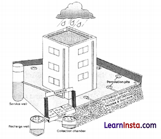
(a) Identify the conservational method depicted in the diagram.
(b) What do the cloud and water droplets represent in the diagram?
(c) Describe the method depicted in the diagram.
Answer:
(a) Rainwater Harvesting.
(b) It represents rainfall, which is being collected and stored for future use.
(c) Rainwater harvesting is a method to collect and store rainwater for various uses. It is a low-cost and eco-friendly technique for preserving every precious drop of water by guiding the rainwater to bore-well, pits, and wells.
Section-C (4×3=12 Marks)
Short Answer type questions
Question 20.
(A) In what ways, developed network of transportation and communication help international trade? [3]
OR
(B) Write three points on how can international trade be detrimental for countries.
Answer:
(A) 1. Developed transportation and communication network takes lesser time and makes the international trade feasible.
2. Better transportation network reduces the cost.
3. Transport and communication network open the new areas and markets for the countries to invest.
OR
(B) International trade can prove to be detrimental to nations in the following ways:
1. It leads to dependence of less developed countries on other more developed countries.
2. Resource get used faster than they can be replenished because composition to trade more, i.e., production rise up.
3. Global trade also results in uneven development level in countries. Critics believe it creates situation where rich countries go richer and poor countries go poorer.
Question 21.
What do you mean by urban agglomeration? [3]
Answer:
An urban agglomeration may consist of any one of the following three combinations:
1. A town and its adjoining urban outgrowths.
2. Two or more contiguous towns with or without their outgrowths.
3. A city and one or more adjoining towns form a contiguous spread with their outgrowths.
![]()
Question 22.
(A) Analyse any three causes for uneven spatial distribution of population in India. [3]
OR
(B) What is the ‘Girmit Act’?
Answer:
(A) The three factors are:
- Climate along with terrain and availability of water largely determines the distribution of the population distribution. Consequently, we observe that the North Indian Plains, deltas, and Coastal Plains have higher proportion of population than the interior districts of southern and central Indian States, Himalayas, some of the north eastern and the western states.
- Another reason is growth of industrialisation in specific region. Industrialisation attracts people (urbanisation), thus lead to uneven spatial distribution of population.
- The concentration of population remains high in cities like Banaras, Patna, Kolkata, Madurai etc because of an early history of human settlement and also development of transport network in these cities. Thus, the ancient cities of India have higher population distribution.
OR
(B) The Girmit Act, also known as the ‘Indian Emigration Act’ of 1859.
1. It passed during the British colonial period.
2. A time-bound contract which stipulated the terms and conditions of the services of the more than a million Indian indentured labourers.
3. Forced to work on the plantations in the British colonies across the globe, under poor living conditions in the 19th and early 20th century.
![]()
Question 23.
“Indiscriminate use of water by increasing population and industrial expansion has led to degradation of the quality of water considerably.” Evaluate the statement. [3]
Answer:
Indiscriminate use of water by an increasing population and industrial expansion has led to degradation of the quality of water considerably. This can be evaluated by the following points:
- Human beings pollute the water through industrial, agricultural and cultural activities.
- Among all, industries are the most significant waste contributor.
- Most of the industrial wastes are disposed off in running water or lakes. Consequently, poisonous elements reach the reservoirs, rivers and other water bodies, which destroy the bio-system of these waters.
Section-D (5×5=25 Marks)
Long Answer Type Questions
Question 24.
Discuss Industries based on Inputs or Raw Materials. [5]
Answer:
On the basis of the raw materials used, the industries are classified into these following categories:
1. Agro based Industries: These industries uses the raw material obtained from agricultural products, like agro processing industries. Major Agro processing industries are food processing, sugar, pickles, fruits juices, beverages (tea, coffee and cocoa), spices and oils fats and textiles (cotton, jute, and silk), rubber, etc.
2. Mineral based Industries: These industries use minerals as raw material. Some industries use ferrous metallic minerals which contain ferrous (iron), such as iron and steel industries, while others use non-ferrous metallic minerals, such as aluminum, copper and jeweller industries.
3. Chemical based Industries: Such industries use natural chemical minerals, e.g. mineral oil (petroleum) is used in petrochemical industry. Salts, sulphur and potash industries also use natural minerals. Chemical industries are also based on raw materials obtained from wood and coal. Synthetic fiber plastic, etc., industries are other examples of chemical based industries.
4. Forest based Raw Material using Industries: The forests provide many major and minor products which are used as raw material. Timber for furniture industry, wood, bamboo and grass for paper industry, lac for cosmetic industries come from forests.
5. Animal based Industries: This industry takes its raw material from animals. Leather for leather
industry and wool for woolen textiles are obtained from animals. Besides, ivory is also obtained
from elephant’s tusks.
Question 25.
(A) Write the economic significance of Panama Canal. [5]
OR
(B) Mention the major problems faced by global road transport in mountainous and hot desert areas.
Answer:
(A) Panama Canal has shortened the distance between eastern and western coasts of North America. This canal connects the Atlantic Ocean in the east to the Pacific Ocean in the west. Its economic significance:
- The canal is about 72 km long and involves a very deep cutting for a length of 12 km.
- It has a six-lock system and ships cross the different levels (26 m up and down) through these locks before entering the Gulf of Panama.
- It shortens the distance between New York and San Francisco by 13,000 km by sea.
- Likewise the distance between Western Europe and the West-coast of U.S.A.; and North-eastern and Central U.S.A. and East and South-east Asia is shortened.
- The economic significance of this Canal is relatively less than that of the Suez. However, it is vital to the economies of Latin America.
OR
(B) The major problems faced by global road transport in mountainous and hot desert areas are:
- The construction and maintenance of roads in the areas of extremely rugged terrains is difficult.
- The cost of construction is really very high due to transportation of material, labour, machinery, technology, etc.
- These roads get destructed easily due to natural calamities/ disasters like landslides, windstorms, earthquakes, etc.
- The construction of roads gets extended for longer period in hilly/desert areas compared to in plain flat lands due to availability and mobility of resources.
- The climatic conditions of mountainous and desert areas hinder the smooth construction and completion as the work gets halted during the period of heavy snowfall, sandstorms, etc.
![]()
Question 26.
(A) “Human progress is not directly proportional to the size of a territory or per capita income.” Give instances to back up your assertion. [5]
OR
(B) What is the definition of human development? Examine the four pillars of development.
Answer:
(A) “Human progress is not directly proportional to the size of a territory or per capita income.” The following instances illustrate this assertion:
- Human progress is not purely composite indicator of economic. Economic factors do not provide idea of human capital formation (education, training, health condition), gender equality and condition of human rights.
- Many minor countries and areas have progressed significantly in comparison to larger countries.
- Gross national product and per capita income are commonly used to measure economic growth and productivity.
- Certain comparatively impoverished nations have been ranked higher than many other countries in terms of the human development index.
- Poverty is reflected inalowstandard of living. Hundreds of thousands of people are malnourished, deprived, illiterate, and have a low degree of human development. It is irrespective of the size of the territory.
- Within India, Kerala performs much better that Punjab and Gujarat in human development index, despite having a lower per capita income.
- Despite having lower GDP, Bhutan, Sri Lanka perform better in human development index as compared to India according to the HDI report 2021 .
OR
(B) Human development is described as the sort of progress that broadens people’s choices and enhances their lives.
- Equity, sustainability, productivity, and empowerment are four ideas in human development. These ideas are known as pillars of human development and are based on human development.
- Equity: It refers to a person’s access to equal chances. There is no discrimination on the basis of gender, colour, income, or caste for the available opportunities. A good life is feasible if resources are made available based on the fact that all individuals are equal.
- Sustainability: It refers to the availability of possibilities in a constant manner. Human growth is feasible when a country’s present and future generations are given opportunities. It must be ensured that equal access to a resources should be available to the next generation.
- Productivity: Human labour productivity, often known as productivity in the context of human work, refers to human development productivity. A country should invest in its productive workforce by improving healthcare, education, and training opportunities. People who are healthy and educated can contribute more to the progress of a country than those who are unhealthy and uneducated.
- Empowerment: It refers to the ability to make decisions. The power and capacity to make a decision can be enhanced through freedom and capabilities. Through excellent administration and people-centered policies, the government may increase empowerment.
Question 27.
(A) Write the distribution of Iron Ore in India. [5]
OR
(B) Explain the importance of five non-conventional sources of energy in India with suitable examples.
Answer:
(A) India is endowed with fairly abundant resources of iron ore. It has the largest reserve of iron ore in Asia.
- The two main types of ore found in our country are hematite and magnetite.
- The total production of iron ore in Indian was around 200 million metric tons in the year 2020.
- About 95 percent of total reserves of iron ore is located in the States of Odisha, Jharkhand, Chhattisgarh, Karnataka, Goa, Telangana, Andhra Pradesh and Tamil Nadu.
- In Odisha, iron ore occurs in a series of hill ranges in Sundergarh, Mayurbhanj and Jhar.
- Similarly hill ranges of Jharkhand have some of the oldest iron ore mines and most of the iron and steel plants are located around them. Other iron ore mines are Noamundi and Guaare located in eastern and western Singhbhum districts. This belt further extends to Durg, Dantewada and Bailadila. Dalli, and Rajhara in Durg are the important mines of iron ore in the country.
- In Karnataka, iron ore deposits occur in Sandur-Hospet area of Ballari district, Baba Budan hills and Kudremukh in Chikkamagaluru district and parts of Shivamogga, Chitradurg and Tumakuru districts.
- The districts of Chandrapur, Bhandara and Ratnagiri in Maharashtra, Karimnagar and Warangal district of Telangana, Kumool, Cuddapah and Anantapur districts of Andhra Pradesh, Salem and Nilgiris districts of Tamil Nadu are other iron mining regions. Goa has also emerged as an
important producer of iron ore.
OR
(B) Non-conventional energy resources are only the renewable energy sources like solar, wind, hydrogeothermal and biomass. These energy sources are more equitably distributed and environmental friendly. The non-conventional energy sources will provide more sustained, eco-friendly cheaper energy after the initial cost is taken care of.
- Wind energy: Wind energy is absolutely pollution free, inexhaustible source of energy. India, already has started generating wind energy. It has an ambitious programme to install 250 wind-driven turbines with a total capacity of 45 megawatts, spread over 12 suitable locations, especially in coastal areas.
- Tidal energy: Large tidal waves are known to occur along the west coast of India. Hence, India has great potential for the development of tidal energy along the coasts but so far these have not yet been utilised.
- Geo-thermal energy: Geothermal energy is now considered to be one of the key energy sources which can be developed as an alternate source. The hot springs and geysers are being used since medieval period. In India, a geothermal energy plant has been commissioned at Manikaran in
Himachal Pradesh and Puga Valley in Ladakh. - Bio-energy: Bio-energy refers to energy derived from biological products which includes agricultural residues, municipal, industrial and other wastes. Bio-energy has a potential to convert waste and garbage into electrical energy. This will improve economic life of rural areas in developing countries, reduce environmental pollution, enhance self-reliance and reduce pressure on fuel wood. One such project converting municipal waste into energy is in Okhla in Delhi.
- Solar Energy: It is cost competitive, environment friendly and easy to construct. It is generally used more in appliances like heaters, crop dryers, cookers, etc. The western part of India has greater potential for the development of solar energy in Gujarat and Rajasthan. The prominent solar parks of India are in Jodhpur (Rajasthan), Tumakuru district (Karnataka) Kumool district (Andhra Pradesh), Rewa (Madhya Pradesh), Ramanathapuram district (Tamil Nadu).
![]()
Question 28.
“Indian ports continued to flourish after independence, despite the setback inflicted by partition.” Support the statement with examples. [5]
Answer:
India has a long history of seaport-based international trade. Following the arrival of European traders and the British colonial rule in of India, these ports became global trade hubs. Local markets were linked to regional markets, regional markets to national markets, and national markets to international markets through sea ports. This procedure was carried on until the country gained independence. However, India suffered a significant setback when the country’s division resulted in the loss of Karachi and Chittagong ports. Karachi port served Pakistan, whereas Chittagong port served East Pakistan (now Bangladesh).
Many additional ports were built to compensate for the loss. For example, on the river Hooghly, Kandala in the west and Diamond Harbour in the east near Kolkata. India was able to rebound from this setback and continue to expand its ports. These Indian ports now handle a substantial volume of local as well as international trade. In most Indian ports, modem infrastructure amenities are present. Many private enterprises have been asked to participate in the modernisation of the country’s ports. Indian ports’ cargo handling capacity has grown from 20 million tonnes in 1951 to over 586 million tonnes in 2008-09. There are now 12 major ports and 200 smaller or intermediate ports operating in India. Major ports handle a bigger portion of overall traffic.
Section-E (2×5=10 Marks)
Map-based questions
Question 29.
On the given political map of the world, the following seven features are shown. Identify any five of these features and write their correct names on the lines marked near each feature. [5]
A. Identify the country which has the highest railway density of1 km of railway for very 6.5 km2.
B. Identify the region is famous for its copper belt in Africa.
C. One of the important country where commercial livestock rearing is practices.
D. Countries that has the highest sex ratio in the world?
E. The country which has highest Human Development Report in 2020.
F. Which one of the following is a thickly populated region in Japan?
G. Identify the country that use Gross National Happiness.
Answer:
A. Belgium
B. Katanga Zambia
C. New Zealand
D. Latvia
E. Norway
F. Kobe – Osaka
G. Bhutan
![]()
Question 30.
On the given political map of India, locate and label any five of the following with appropriate symbols: [5]
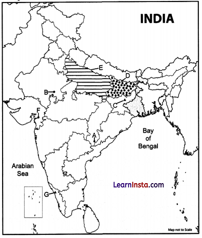
A. Iron mine in Chhattishgarh.
B. Nuclear power plant in Rajasthan.
C. Coal mine in Jharkhand.
D. Identify states that has the lowest female literacy rate.
E. Identify the state that has highest density of population.
F. Identify the mining town in Gujarat.
G. Identify the important transport city in Kerala.
Answer:
A. Bailadila
B. Rawatbhata
C. Bokaro
D. Bihar
E. Uttar Pradesh
F. Ankleshwar
G. Kozhikode