Students often revise Class 6 SST Extra Questions and Class 6th SST Chapter 1 Locating Places on the Earth Important Extra Question Answer before their exams for better preparation.
Locating Places on the Earth Class 6th Extra Question Answer
Class 6 Social Science SST Chapter 1 Locating Places on the Earth Class 6 Extra Questions and Answers
Locating Places on the Earth Class 6 Extra Questions Very Short Answer Type
Question 1.
What does a map represent?
Answer:
A map represents an area and shows how to get to different places.
Question 2.
Name the four cardinal directions.
Answer:
North, East, South, and West:
Question 3.
What is an atlas?
Answer:
An atlas is a book or collection of maps.
Question 4.
What is the scale on a map used for?
Answer:
The scale on a map is used to represent the distance on the ground.
![]()
Question 5.
hat is the Prime Meridian also known as?
Answer:
The Prime Meridian is also known as the Greenwich Meridian.
Question 6.
What is latitude?
Answer:
Latitude measures the distance from the Equator.
Question 7.
What are meridians of longitude?
Answer:
Meridians of longitude are imaginary lines running from the North Pole to the South Pole.
Question 8.
What is the Equator?
Ans.
The Equator is the line-of 0° latitude, halfway between the North Pole and the South Pole.
Question 9.
How many degrees is the Earth divided into for latitude?
Answer:
The Earth is divided into 90 degrees for latitude.
Question 10.
What is the International Date Line?
Answer:
The International Date Line is an imaginary line at approximately 180° longitude, marking the chiange of a day.
Question 11.
What is a pole?
Answer:
The two ends of the axis are called poles.
Question 12.
What is a grid?
Answer:
The network of lines formed by latitudes an longitudes (by bisecting each other) are called grids.
Question 13.
Define Equator.
Answer:
Equator is an imaginary line which divides the Earth almost into two equal parts.
Question 14.
What is Prime Meridian?
Answer:
The meridian which passes through veetw. where the British Royal Observatory is located is called the Prime Meridian. Its value is 0° longitude.
Question 15.
Where does the Temperate Zone lie?
Answer:
The Temperate Zone lies between the tropic of Cancer and Arctic Circle in the Northern Hemisphere and the Tropic of Capricorn and Antarctic Circle in the Southern Hemisphere.
Question 16.
Name the direction that lies at the top of a map.
Answer:
North direction.
Question 17.
Define conventional symbols.
Answer:
The symbols which are used with general agreement to make the map clear and easier to read are known as conventional symbols.
Question 18.
What is a map?
Answer:
A map is a representation of the earth’s surface or a part of it on a flat surface according to scale.
Locating Places on the Earth Class 6 Extra Questions Short Answer Type
Question 1.
Explain the difference between a political map and a physical map.
Answer:
A political map shows boundaries and cities, whereas a physical map shows natural features like mountains and rivers.
![]()
Question 2.
Why is the Equator considered the largest circle of latitude:
Answer:
The Equator is considered the largest circle of latitude because it is the line of 0° latitude and divides the Earth into Northern and Southern Hemispheres.
Question 3.
What are the main uses of a map?
Answer:
The main uses of a map are to represent areas, show locations, and provide directions.
Question 4.
Describe the importance of the Prime Meridian.
Ans.
The Prime Meridian is important as it is the reference point for measuring longitude and divides the Earth into Eastern and Western Hemispheres.
Question 5.
How do time zones relate to meridians of longitude?
Answer:
Time zones are based on meridians of longitude, with each zone representing a specific hour difference from Greenwich Mean Time (GMT).
Question 6.
Why do temperate zones experience moderate temperature?
OR
The temperature of the temperate zone is moderate. Why?
Answer:
Temperate zones experience moderate temperature because the rays of the Sun always strike at an angle in these regions, which reduces the eat.
Question 7.
Why is Greenwich time called Greenwich Mean Time?
Answer:
Greenwich time is called Greenwich Mean Time because GMT is the local time of the old Greenwich observatory, i.e., 0°. It is adopted uniformly by all the countries at the international level.
Question 8.
Name the two imaginary lines draw on the surface of the Earth.
Answer:
The two imaginary lines drawn on the surface of the Earth are:
(i) The lines on the axis, which form the North and South poles.
(ii) The Equator, which runs midway between the North and South Poles.
Question 9.
How can we draw the Greatest Circle on the Earth?
Answer:
Slowly rotate the globe on the N-S axis and mark a series of points near the middle of the globe from West to East. Join these points and a big circle around the globe is formed. This circle is the largest possible circle that can be drawn on the Earth. It is known as the Equator.
Question 10.
Why are the longitudes and latitudes drawn on globe?
Answer:
The Earth is spherical in shape and thus, it is impossible to locate the places on the Earth. To locate a place on the globe, latitudes and longitudes are drawn. The latitudes and longitudes point out the exact positions of places on the Earth’s surface.
Question 11.
What are Political Maps?
Answer:
When the boundaries of the continents, countries, states, districts, capital cities and towns are shown on a map, it is called a Political Map.
Question 12.
What do you know about Physical Maps?
Answer:
The maps which show mountains, plains, valleys, plateaus, rivers, lakes and contours, etc., are called Physical Maps. They are also known as Relief Maps.
Locating Places on the Earth Class 6 Extra Questions Long Answer Type
Question 1.
Discuss the significance of the Equator and the Prime Meridian in geography.
Answer:
The Equator and the Prime Meridian are significant in geography as they serve as the referchce lines for latitude and longitude, respectively. The Equator divides the Earth into the Northern and Southern Hemispheres, while the Prime Meridian divides it into the Eastern and Western Hemispheres. These lines help in determining locations, understanding climate zones, and measuring time differences. The Equator is also the largest circle of latitude, and the Prime Meridian is the starting point for measuring longitude.
![]()
Question 2.
Explain how maps and globes help in understanding the Earth’s geography.
Answer:
Maps and globes are essential tools for understanding the Earth’s geography. Maps provide a flat representation of the Earth’s surface, allowing for detailed views of specific areas, while globes offer a three-dimensional perspective, accurately depicting the shape and size of continents and oceans.
They help in visualizing geographical features, understanding spatial relationships, planning routes, and studying various aspects of the Earth’s surface. Maps can also be specialized to show political boundaries, physical landscapes, and thematic information, enhancing our knowledge of different regions.
Question 3.
How do latitude and longitude work together to pinpoint any location on Earth? Provide an example.
Answer:
Latitude and longitude work together to pinpoint any location on Earth by creating a grid system of coordinates. Latitude measures the distance north or south from the Equator, with the Equator at 0° latitude and the poles at 90° N (North Pole) and 90° S (South Pole). Longitude measures the distance east or west from the Prime Meridian, which is at 0° longitude and passes through Greenwich, England, with values ranging from 0° to 180° east or west.
By combining these two measurements, any location on Earth’s surface can be precisely identified with a pair of coordinates. For example, the coordinates for the city of New Delhi, India, are approximately 28.6139° N latitude and 77.2090° E longitude.
This means New Delhi is located 28.6139 degrees north of the Equator and 77.2090 degrees east of the Prime Meridian. This system allows for accurate navigation and mapping of locations around the world.
Question 4.
Which longitude is taken as the International Date Line and why?
Answer:
The International Date Line (IDL) is an imaginary line on the surface of the Earth opposite the Prime Meridian, where the date changes as one travels across the East or West. Roughly along 180° longitude, it almost corresponds to the time zone boundary separating -12 and +12 hours, Greenwich Mean Time (GMT). Crossing the IDL, travelling east results in a day or 24 hours being added and crossing west results in a day being subtracted. The exact number of hours depends on the time zones.
Question 5.
Explain the important parallels of latitudes.
Answer:
Besides the Equator (0°), the North Pole (90°N) and the South Pole (90° S) are four important parallels of latitude.
(i) Tropic of Cancer: It is at an angular distance of 23 ½, from the Equator. It is important because on 21st, June, the Sun is directly over it.
(ii) Tropic of Capricorn: It is at an angular distance of 23½° S from the Equator. On 22nd December, the Sun is over the latitude.
(iii) Arctic Circle: It is at a distance of 66½° N from the Equator. On 21st June there is 24 hours daylight on the parallel.
(iv) Antarctic Circle: It is at a distance of 66½° S of the Equator. On 22nd December, there is 24 hours daylight on this parallel.
Question 6.
Why do we need to understand maps?
Answer:
We need to understand maps because of the following reasons:
- To find our way around a city.
- To find the location of specific places in a new city.
- To find the shortest route to a specific spot.
- To find out locations of petrol pumps, police stations and rest houses on highways.
- In case of emergency, it helps to find the nearest hospital or medical aid.
Question 7.
What do the following colours represent on map?
Answer:
- Blue—Lakes, rivers, streams, oceans, reservoirs, etc.
- Red—Major highways, roads, urban areas, airports, special interest sites, military sites, place names, buildings, borders.
- Yellow—Built-up or urban areas.
- Green—Parks, golf courses, forest, orchards, highways.
- Brown—Deserts, historical sites, national parks, military reservations or bases, contour (elevation) lines.
- Black—Railways, highways, bridges, place names, buildings, borders.
Question 8.
Distinguish between parallels of latitudes and meridians of longitudes.
Answer:
The difference between parallels of latitudes and meridians of longitudes are given below:
- Parallels of Latitudes: All parallel circles from the Equator up to the poles are called parallels of latitude. In total, there are 180° latitudes that is 90° North and 90° South.
- Meridians of Longitudes: All semi-circles running from North Pole to South pole are called meridians of longitude. In total, there are 360° longitudes, that is, 180° East and 180° West.
Question 9.
Why is it necessary to have standard time? Also define Indian Standard Time (IST).
Answer:
It is necessary to have a standard time because:
(i) Different meridians have different time, which makes it difficult to prepare a time table for trains and flights.
(ii) It helps to maintain uniformity of time througnou the country. Indian Standard Time: In India, the longitude 82½°’E is treated as the standard mendian and local time at this meridian is taken as the stands time for the whole country. It is known as Indi Standard Time (IST).
Locating Places on the Earth Class 6 Source-based Questions
Read the below passage and answer the following questions:
A map is a representation or a drawing of an area. It shows us how to get to different places. There are different kinds of maps, such as political, physical, thematic, and road maps. Political maps show countries and cities, while physical maps show natural features like mountains and rivers. Thematic maps provide specific kinds of information, such as population density or climate.
Road maps are used for navigation, showing roads, highways, and important landmarks. Maps have various elements, including symbols, scales, and directions, which help in understanding the represented area. The Prime Meridian and the Equator are important reference lines in geography, dividing the Earth into hemispheres and helping in determining locations.
Question 1.
What is the main purpose of a map?
Answer:
The main purpose of a map is to represent an area and show how to get to different places.
Question 2.
Name two types of maps mentioned in the passage and their features.
Answer:Two types of maps mentioned are political maps, which show countries and cities, and physical maps, which show natural features like mountains and rivers.
![]()
Question 3.
What elements are commonly found in maps?
Answer:
Common elements found in maps include symbols, scales, and directions.
Locating Places on the Earth Class 6 Picture-based Questions
Observe the picture and answer the following questions:
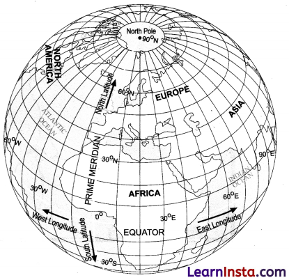
Question 1.
Which direction represents latitude?
Answer:
Latitude measures the distance north or south of the equator.
Question 2.
What is measured by longitude?
Answer:
Longitude measures the distance east or west from the Prime Meridian.
![]()
Question 3.
What are the divisions created by the Equator and the Prime Meridian called?
Answer:
The divisions created by the Equator and the Prime Meridian are called hemispheres. The Equator divides the Earth into the Northern and Southern Hemispheres, while the Prime Meridian divides it into the Eastern and Western Hemispheres.
Locating Places on the Earth Class 6 Map Skill Questions
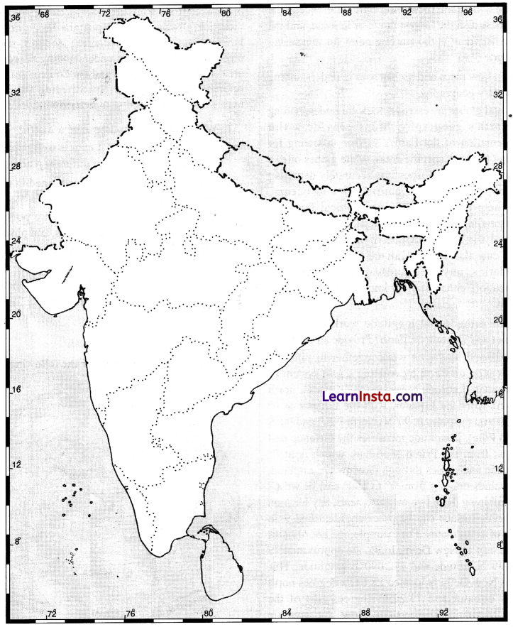
On the outline map of India, mark the Ujjaini Prime Meridian.