Students can access the CBSE Sample Papers for Class 11 Geography with Solutions and marking scheme Set 1 will help students in understanding the difficulty level of the exam.
CBSE Sample Papers for Class 11 Geography Set 1 with Solutions
Time : 3 Hours
Maximum Marks : 70
General Instructions:
- This question paper contains 30 questions. All questions are compulsory.
- This question paper is divided into five sections. Sections-A, B, C, D and E.
- Section A – Question number 1 to 17 are Multiple Choice Type Questions carrying 1 mark each.
- Section B – Question number 18 and 19 are Source Based Questions carrying 3 marks each.
- Section C – Question numbers 20 to 23 are Short Answer Type Questions carrying 3 marks each. Answer to these questions shall be written in 80 to 100 words.
- Section D – Question number 24 to 28 are Long Answer Type Questions carrying 5 marks each. Answer to these questions shall be written in 120 to 150 words.
- Section E – Question number 29 and 30 are Map based questions.
Section – A
Question 1.
There are two statements marked as Assertion (A) and Reason (R). Mark your answer as per the codes provided
below. 1
Assertion: The five Planets (Jupiter, Saturn, Uranus, Neptune, and Pluto) are known as Jovian Planets.
Reason: They are similar to Jupiter.
Options:
(A) Both (A) and (R) are true but (R) is not the correct explanation of (A).
(B) Both (A) and (R) are true and (R) is the correct explanation of (A).
(C) Both (A) and (R) are incorrect.
(D) (A) is correct but (R) is incorrect.
Answer:
Option (C) is correct.
Explanation: Only Jupiter, Saturn, Uranus, and Neptune are called Jovian Plants(Gas Giants) as they all are similar to Jupiter.
Question 2.
Consider the following and choose the correct answer with the help of the given codes: 1
| Column I | Column II |
| i. Aphelion | 1. 147 million km |
| ii. Perihelion | 2. Albedo |
| iii. Heat budget | 3. Normal lapse rate |
| iv. Altitude | 4. 152 million km |
Options:
Answer:
Option (C) is correct.
Explanation:
- Aphelion refers to the point in the Earth’s orbit when it is farthest away from the Sun, and the distance at this point is approximately 152 million kilometres.
- Perihelion refers to the point in the Earth’s orbit when it is closest to the Sun, and the distance at this point is approximately 147 million kilometres.
- Albedo is the reflectivity of a surface that determines the absorption of solar energy and heat budget.
- Decreasing temperature with increasing altitude is known as Normal lapse rate.
Question 3.
What causes rainfall in the coastal areas of Tamil Nadu at the beginning of winter? 1
(A) South-West monsoon
(B) Temperate cyclones
(C) North-Eastern monsoon
(D) Local air circulation
Answer:
Option (C) is correct.
Explanation: This winter rainfall is caused when the northeast wind takes a round in the Bay of Bengal and becomes moist to cause rainfall.
Question 4.
Consider the following statements and choose the correct answer with the help of the given options: 1
I. Water vapour decreases with altitude.
II. In warm and wet tropics, it may account for 4 per cent of the air by volume while in polar regions it may be less than one per cent of the air.
Options:
(A) Both statements are true
(B) Only statement I is true
(C) Only statement II is true
(D) Both statements are wrong
Answer:
Option (A) is correct.
Explanation: Water vapour decreases from the equator towards the poles.
Question 5.
Given below is a list of different climatic features and their characteristics, identify which of the following pair is not correctly matched. 1
| Descriptor | Characteristics |
| (A) Isotherm | Parallel to latitudes |
| (B) Convection | Horizontal heating |
| (C) Loo | Advection process |
| (D) Earth’s axis | The angle of 661/2 degrees with the plane of orbit |
Answer:
Option (B) is correct.
Explanation: Convection is due to vertical heating of air in the form of air current.
Question 6.
The earth’s surface is continuously subjected to external forces induced basically by: 1
(A) sunlight
(B) wind
(C) water
(D) power
Answer:
Option (A) is correct.
Explanation: Sunlight is a source of energy that drives various processes on Earth’s surface, including heating, evaporation, and weathering.
Question 7.
The chemical addition of water is called as: 1
(A) hydration
(B) dehydration
(C) reduction
(D) oxidation
Answer:
Option (A) is correct.
Explanation: Hydration refers to the process of adding water to a substance, resulting in a chemical reaction that usually involves the formation of a hydrated compound.
Question 8.
Which one of the following processes is a gradational process: 1
(A) Deposition
(C) Volcanism
(B) Diastrophism
(D) Erosion
Answer:
Option (D) is correct.
Explanation: Erosion is a gradual process that involves the wearing away and transportation of rock and soil by natural agents like water, wind, and ice. It leads to the reshaping of the Earth’s surface over time.
Question 9.
The only active volcano of India is the: 1
(A) Narcondam Island
(B) Barren Island
(C) Heaven Island
(D) Halo Island
Answer:
Option (B) is correct.
Explanation: Barren Island, is the only active volcano in India and is situated in the Nicobar Islands.
Question 10.
Consider the following statements and choose the correct answer with the help of given options: 1
Statement I: Waves travel because winds push the water body in its course while gravity pulls the crest of the waves downward.
Statement II: The actual motion of the water beneath the waves is circular.
(A) Only statement I is correct
(B) Only statement II is correct
(C) Both the statements are correct, and statement II correctly explains statement I
(D) Both the statements are true but not related with each other
Answer:
Option (C) is correct.
Explanation: The falling water pushes the former trough upward, and the waves move to a new position.
Question 11.
Arrange the following rivers from South to North direction: 1
(i) Mahanadi
(ii) Godavari
(iii) Cauvery
(iv) Krishna
Options:
(A) i, ii, iv, iii
(B) iii, iv, ii, i
(C) iii, iv, i, ii
(D) iii, i, ii, iv
Answer:
Option (B) is correct.
Explanation: From South to North, given rivers can be arranged as Cauvery, Krishna, Godavari, and Mahanadi.
Question 12.
Which branch of the jet stream does exercise a significant influence on the winter weather in India? 1
(A) northern
(B) southern
(C) eastern
(D) western
Answer:
Option (B) is correct.
Explanation: This southern jet stream blows to the south of the Himalayan ranges along 25° north latitude.
Question 13.
The Western cyclonic disturbances originate over the: 1
(A) Arabian Sea
(B) Mediterranean Sea
(C) Bay of Bengal
(D) Caspian Sea
Answer:
Option (B) is correct.
Explanation: These disturbances are weather phenomena of the winter months brought in by the westerly flow from the Mediterranean region.
Question 14.
A high-pressure centre in the region lying to the north of the Himalayas develops during: 1
(A) summer
(B) winter
(C) autumn
(D) monsoon
Answer:
Option (B) is correct.
Explanation: During winters, high-pressure centre develops in the region lying to the north of the Himalayas.
Study the following graph and answer questions no 15 to 17.
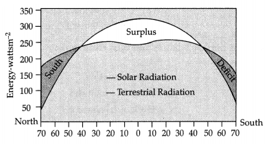
Question 15.
As per the graph, there is a deficit of net radiation balance beyond which of the following latitudes. 1
(A) 40
(B) 30
(C) 50
(D) 45
Answer:
Option (A) is correct.
Explanation: Net radiation is downward at low latitudes and upward at high latitudes.
Question 16.
According to the graph, what is the measurement of solar radiation in energy-watts m~2 at 0 degree latitude? 1
(A) 300
(B) 200
(C) 100
(D) 50
Answer:
Option (A) is correct.
Explanation: The measurement of solar radiation in energy-watts m-2 at 0 degree latitude is 300.
Question 17.
According to the graph, the surplus of solar radiation is found around the: 1
(A) South pole
(B) North pole
(C) Equator
(D) Greenwich meantime
Answer:
Option (C) is correct.
Explanation: At the equator solar energy received is maximum.
Section – B
Question 18 & 19 are Source Based Questions.
Question 18.
Read the given Passage carefully and answer the questions that follow: 3
All the branches of physical geography have an interface with natural sciences. Traditional physical geography is linked with geology, meteorology, hydrology and pedology; thus, geomorphology, climatology, oceanography and soil geography, respectively, have very close links with the natural sciences as they derive their data from these sciences. Biogeography is closely related to botany and zoology as well as ecology as human beings are located in different locational niches. A geographer should have some proficiency in mathematics and art, particularly in drawing maps.
Geography is very much linked with the study of astronomical locations and deals with latitudes and longitudes. The shape of the earth is the geoid, but the basic tool of a geographer is a map that is a two-dimensional representation of the earth. The problem of converting geoids into two dimensions can be tackled by projections constructed graphically or mathematically. The cartographic and quantitative techniques require sufficient proficiency in mathematics, statistics and econometrics. Maps are prepared through artistic imagination. Making sketches, mental maps and cartographic work requires proficiency in arts.
a. All branches of physical geography have an interface with?
b. Which science is closely related to botany and zoology as well as ecology?
c. The problem of converting geoids into two dimensions can be tackled by projections constructed:
Answer:
a. Natural sciences
b. Biogeography
c. Constructed graphically and mathematically
Question 19.
Observe the below given image and answer the following. 3
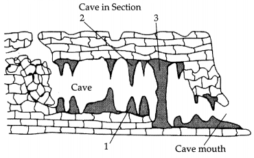
a. Which type of landform is shown in the figure (by 1,2 & 3)?
b. Specify the name of 1,2 & 3.
c. These landforms are generally found in which type of topography?
Answer:
a. 1, 2, & 3 are denoting Depositional Landforms
b. 1- Stalagmite, 2- stalactite, 3- pillar
c. These types of landforms are usually found in Karst topography.
Section – C
Question numbers 20 to 23 are Short Answer Type Questions.
Question 20.
How did the atmosphere originate? 3
OR
How did the earth develop its different layers?
Answer:
- Gases were released from the earth’s interior such as water vapour and other gases.
- These were water vapour, nitrogen, carbon dioxide, methane, ammonia and little free oxygen.
- The process of outpouring the gases from the interior of the earth is called degassing. The process of differentiation created the present atmosphere.
OR
During the formation of the moon, due to the giant impact, the earth was further heated up. It is through the process of differentiation that the earth-forming material got separated into different layers.
Starting from the surface to the central parts, we have layers like the crust, mantle, outer core and inner core.
The density of the material increases from the crust to the core.
Question 21.
What are the primary forces that influence the currents? 3
Answer:
The primary forces that influence the currents are:
- Heating by solar energy: It causes the water to expand. That is why, near the equator, the ocean water is about 8 cm higher in level than in the middle latitudes. This causes a very slight gradient and water tends to flow down the slope.
- Wind: Wind blowing on the surface of the ocean pushes the water to move. Friction between the wind and the water’s surface affects the movement of the water body in its course.
- Gravity: Gravity tends to pull the water down the pile and create gradient variation.
- The Coriolis force: It intervenes and causes the water to move to the right in the Northern Hemisphere and to the left in the Southern Hemisphere
Question 22.
What do you know about the size of India with reference to the world? Which countries are more significant than
India in terms of size? What do you know about India’s location on the globe? 3
OR
What are the implications of India having a long coastline?
Answer:
India with its area of 3.28 million sq. km accounts for 2.4 per cent of the world’s land surface area and stands as the seventh largest country in the world. Russia, China, Canada, Brazil and Australia are larger than India in terms of size. India lies in the Northern Hemisphere. The mainland of India extends from Kashmir in the north to Kanyakumari in the south and Arunachal Pradesh in the East to Gujarat in the West. India’s territorial limit further extends towards the sea up to 12 nautical miles (about 21.9 km) from the coast. It extends between latitudes 8°4’N (Kanyakumari, Cape Caverian) and 37°6’N (Indira Point, J&K) and longitudes 68°7’E (Dwarka, Gujarat) and 97°25’E (Arunachal Pradesh).
OR
The implications of India having a long coastline is that it helps India establish close contacts with West Asia Africa and Europe from the western coast and with Southeast Asia and East Asia from the Eastern coast. The coastline also provides a strategic central location to India. It also ensures good trade relations with other countries. It provides access to marine resources. It provides economic opportunities such as fishing, ports, wind power, tidal energy, sea salt, etc. Number of jobs are generated due to the long coastline.
Question 23.
Differentiate between conduction and convection. 3
Answer:
| S.no | Conduction | Convection |
| 1. | The air in contact with the land gets heated slowly and the upper layers in contact with the lower layers also get heated. This process is called conduction. | The process of vertical heating of the atmosphere is known as convection. |
| 2. | The Earth after being heated by insolation transmits the heat to the atmospheric layers near the Earth in a long waveform. | The air in contact with the earth rises vertically on heating in the form of currents and further transmits the heat of the atmosphere. |
| 3. | Conduction takes place when two bodies of unequal temperature are in contact with each other, there is the flow of energy from the warmer to the cooler body. | The convection transfer of energy is confined only to the troposphere. |
Section – D
Question numbers 24 to 28 are Long Answer Type Questions.
Question 24.
Explain in detail the different types of earthquakes. 5
Answer:
The different types of earthquakes are:
- Tectonic earthquake: The most common ones are tectonic earthquakes. These are generated due to the sliding of rocks along a fault plane.
- Volcanic earthquake: A special class of tectonic earthquake is sometimes recognised as a volcanic earthquake. However, these are confined to areas of active volcanoes.
- Collapse earthquake: In areas of intense mining activity, sometimes the roofs of underground mines collapse causing minor tremors. These are called collapse earthquakes.
- Explosion earthquake: Ground shaking may also occur due to the explosion of chemical or nuclear devices. Such tremors are called explosion earthquakes.
- Reservoir-induced earthquakes: The earth¬quakes that occur in the areas of large reservoirs are referred to as reservoir-induced earthquakes.
Question 25.
Explain the factors that control the temperature distribution of any place. 5
Answer:
The temperature of the air at any place is influenced by (i) the latitude of the place; (ii) the altitude of the place; (iii) the distance from the sea, the air-mass circulation; (iv) the presence of warm and cold ocean currents; (v) local aspects
(i) Latitude: The temperature of a place depends on the insolation received. The insolation varies according to the latitude; hence, the temperature also varies accordingly.
(ii) Altitude: The atmosphere is indirectly heated by terrestrial radiation from below. Therefore, the places near the sea level record higher temperatures than the places situated at higher elevations. In other words, the temperature generally decreases with increasing height.
(iii) Distance from the sea: Compared to land, the sea gets heated slowly and loses heat slowly. Land heats up and cools down quickly. Therefore, the variation in temperature over the sea is less compared to land. The places situated near the sea come under the moderating influence of the sea and land breezes which moderate the temperature.
(iv) Air mass: An air mass is a volume of air defined by its temperature and water vapour content. Air masses may cover many hundreds or thousands of square miles and adapt to the characteristics of the surface below them. Like the land and the sea breezes, the passage of air masses also affects the temperature. The places, which come under the influence of warm air masses experience higher temperatures and the places that come under the influence of cold air masses experience low temperatures.
(v) Ocean currents: An ocean current is a seasonal directed movement of seawater generated by forces acting upon this mean flow, such as breaking waves, wind, the Coriolis effect, temperature and salinity differences, while tides are caused by the gravitational pull of the sun and the moon. the places located on the coast where the warm ocean currents flow record higher temperatures than the places located on the coast where the cold currents flow.
Question 26.
What are the characteristics of monsoonal rainfall? 5
OR
What is global warming? What are the effects of global warming?
Answer:
Characteristics of monsoonal rainfall are:
(i) Rainfall received from the southwest monsoons is seasonal in character and occurs between June and September.
(ii) Monsoonal rainfall is largely governed by relief or topography. For instance, the windward side of the Western Ghats registers a rainfall of over 250 cm. Again, the heavy rainfall in the northeastern states can be attributed to their hill ranges and the Eastern Himalayas.
(iii) The monsoon rainfall has a declining trend with increasing distance from the sea. Kolkata receives 119 cm of rain during the southwest monsoon period, Patna 105 cm, Allahabad 76 cm and Delhi 56 cm.
(iv) The monsoon rains occur in wet spells of a few days duration at a time. The wet spells are interspersed with rain-less intervals known as ‘breaks’. These breaks in rainfall are related to the cyclonic depressions mainly formed at the head of the Bay of Bengal and their crossing into the mainland. Besides the frequency and intensity of these depressions, the passage followed by them determines the spatial distribution of rainfall.
(v) The summer rainfall comes in a heavy downpour leading to considerable runoff and soil erosion. Monsoons play a pivotal role in the agrarian economy of India because over three-fourths of the total rain in the country is received during the southwest monsoon season.
(vi) Its spatial distribution is also uneven which ranges from 12 cm to more than 250 cm. The beginning of the rains sometimes is considerably delayed over the whole or a part of the country.
(vii) The rains sometimes end considerably earlier than usual, causing great damage to standing crops and making the sowing of winter crops difficult. (Any five)
OR
Global warming, also referred to as climatic change, is the observed century-scale rise in the average temperature of the Earth’s climate system and its related effects. Effects of global warming:
(i) The temperature of the world is significantly increasing. Carbon dioxide produced by human activities is a major source of concern. This gas, released to the atmosphere in large quantities by burning of fossil fuel, is increasing gradually.
(ii) Other gases like methane, chlorofluorocarbons and nitrous oxide which are present in much smaller concentrations in the atmosphere, together with carbon dioxide are known as greenhouse gases. These gases are better absorbers of long wave radiations than carbon dioxide and so, are more effective at enhancing the greenhouse effect.
(iii) Global warming has led to the rise in the sea level and melting of glaciers and sea ice due to warming. According to the current prediction, on average, the sea level will rise 48 cm by the end of the twenty-first century. This would increase the incidence of annual flooding.
(iv) Climatic change would promote insect-borne diseases like malaria and lead to a shift in climatic boundaries, making some regions wetter and others drier.
(v) Agricultural patterns would shift and the human population as well as the ecosystem would experience change.
Question 27.
What are the important geomorphological features found in the river valley plains? 5
OR
Make a comparison of the island groups of the Arabian Sea and the Bay of Bengal.
Answer:
Alluvial fans are formed when streams flowing from higher levels break into foot slope plains of low gradient. Normally very coarse load is carried by streams glowing over mountain slopes. This load becomes too heavy for the streams to be carried over gentler gradients and gets dumped and spread as a broad low to high cone-shaped deposit called an alluvial fan. Usually, the streams which flow over fans are not confined to their original channels for long and shift their position across the fan forming many channels called distributaries. Alluvial fans in humid areas show normally low cones with gentle slopes form as low cones.
Delta is like alluvial fans but develop at a different location. The load carried by the rivers is dumped and spread into the sea. If this load is not carried far away into the sea or distributed along the coast, it spreads and accumulates. Such areas over flood plains build up by abandoned or cut-off channels contain coarse deposits. The flood deposits of spilt waters carry relatively finer materials like silt and clay. The flood plains in a delta are called delta plains.
Floodplain is a major landform of river deposition. Large-sized materials are deposited first when the stream channel breaks into a gentle slope. Thus, normally, fine-sized materials like sand, silt and clay are carried by relatively slow-moving waters in gentler channels usually found in the plains and deposited over the bed and when the waters spill over the banks during flooding above the bed. These river valley plains have a fertile alluvial soil cover which supports a variety of crops like wheat, rice, sugarcane and jute, and hence, supports a large population.
OR
| S.no | Andaman and Nicobar Islands | Lakshadweep Islands |
| 1. | It lies 1200 km away from the Indian mainland in the Bay of Bengal | It lies opposite to the coast of Kerala in the Arabian Sea at a distance of 280-480km. |
| 2. | Port Blair is the capital. | Kavarati is the capital. |
| 3. | They are approx. 572 islands. | They are approx. 36 islands. |
| 4. | They have two volcanic islands: Barren Island-active volcano and Norkandom Island, an extinct Island. | Minicoy is the largest island and is a major tourist hub. |
| 5. | The water body separating the Andaman and Nicobar Islands is called the 10 Degree Channel. | The water body separating the Lakshadweep Islands is called the eleventh-degree channel |
Question 28.
Why are the rivers in India considered important? 5
OR
Write a note on the river system of the peninsular drainage.
Answer:
Rivers in India are of paramount importance, with their significance deeply rooted in the country’s economic, cultural, and ecological realms.
(i) Irrigation: Rivers in India play a pivotal role in agriculture by providing a reliable source of water for irrigation. Rivers like the Ganges, Yamuna, and Godavari are lifelines for agriculture. For instance, the Ganges Basin supports the cultivation of rice, wheat, and sugarcane across multiple states, ensuring food security for millions of people.
(ii) Transportation: Historically, rivers have served as natural trade routes facilitating the movement of goods and people. The Brahmaputra River serves as a vital trade route in Northeast India for transportation. The port city of Kolkata, situated on the Hooghly River, remains a key hub for maritime trade.
(iii) Cultural Significance: Rivers are deeply ingrained in Indian culture and spirituality. The Yamuna River is intrinsically tied to Indian culture and spirituality, with Mathura and Vrindavan along its banks being important pilgrimage sites associated with Lord Krishna.
(iv) Biodiversity and Ecosystems: Rivers sustain a rich diversity of aquatic life, including various fish species and other organisms. The Western Ghats’ numerous rivers, including the river Cauvery, host diverse aquatic life and sustain rich ecosystems. The Brahmaputra floodplains in Assam provide crucial habitat for the endangered Indian rhinoceros.
(v) Hydropower Generation: India harnesses the energy potential of rivers through hydropower projects. These projects contribute significantly to the country’s electricity generation, reducing dependency on fossil fuels and promoting clean energy sources. The Sutlej River in Himachal Pradesh powers several hydroelectric plants, contributing significantly to the state’s electricity generation.
(vi) Natural Reservoirs: Rivers serve as natural reservoirs, helping to store and regulate water resources. The Bhakra-Nangal Dam on the Sutlej River and the Hirakud Dam on the Mahanadi River serve as essential water reservoirs, helping regulate water supply for irrigation, industries, and domestic use.
(any five points)
OR
There are a large number of river systems in the Peninsular drainage. A brief account of the major Peninsular River systems is given below:
(i) The Mahanadi: It rises near Sihawa in the Raipur district of Chhattisgarh and runs through Odisha to discharge its water into the Bay of Bengal. It is 851 km long and its catchment area spreads over 1.42 lakh sq. km. Some navigation is carried on in the lower course of this river. Fifty-three per cent of the drainage basin of this river lies in Madhya Pradesh and Chhattisgarh, while 47 per cent lies in Orissa.
(ii) The Godavari: It is the largest Peninsular River system. It is also called the Dakshin Ganga. It rises in the Nasik district of Maharashtra and discharges its water into the Bay of Bengal. Its tributaries run through the states of Maharashtra, Madhya Pradesh, Chhattisgarh, Odisha and Andhra Pradesh. It is 1,465 km long with a catchment area spreading over 3.13 lakh sq. km 49 per cent of this, lies in Maharashtra, 20 per cent in Madhya Pradesh and Chhattisgarh, and the rest in Andhra Pradesh.
(iii) The Krishna: It is the second largest east¬flowing Peninsular River which rises near Mahabaleshwar in Sahyadri. Its total length is 1,401 km. The Koyna, the Tungabhadra and the Bhima are its major tributaries Of the total catchment area of the Krishna, 27 per cent lies in Maharashtra, 44 per cent in Karnataka and 29 per cent in Andhra Pradesh.
(iv) The Kaveri: It rises in Brahma Giri hills (1,341m) of Kogadu district in Karnataka. Its length is 800 km and it drains an area of 81,155 sq. km. Since the upper catchment area receives rainfall during the southwest monsoon season (summer) and the lower part during the northeast monsoon season (winter), the river carries water throughout the year with comparatively less fluctuation than the other Peninsular rivers.
(v) The Narmada: It originates on the western flank of the Amarkantak plateau at a height of about 1,057 m. Flowing in a rift valley between the Satpura in the south and the Vindhyan range in the north, it forms a picturesque gorge in marble rocks and the Dhuandhar waterfall near Jabalpur. After flowing a distance of about 1,312 km, it meets the Arabian Sea south of Bharuch, forming a broad 27 km long estuary. Its catchment area is about 98,796 sq. km.
(vi) The Tapi: It is the other important westward¬flowing river. It originates from Multai in the Betul district of Madhya Pradesh. It is 724 km long and drains an area of 65,145 sq. km. Nearly 79 per cent of its basin lies in Maharashtra, 15 per cent in Madhya Pradesh and the remaining 6 per cent in Gujarat.
(vii) Luni: It is the largest river system of Rajasthan, west of Aravali. It originates near Pushkar in two branches, i.e., the Saraswati and the Sabarmati, which join with each other at Govindgarh. From here, the river comes out of Aravali and is known as Luni. It flows towards the west till Telwara and then takes a southwest direction to join the Rann of Kuchchh.
Section – E
Question numbers 29 & 30 are Map based
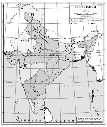
Question 29.
Locate and label any five of the following geographical help of the given information:
(A) The river is known as the ‘Sorrow of Bihar’.
(B)The highest mountain range of Maharashtra.
(C) The famous national park of Gujarat.
(D) A famous pass of Western Ghat in Maharashtra.
(E) A Right Bank tributary of Ganga.
(F) A freshwater lake of Jammu and Kashmir.
(G) Desert Area in India.
Answer:
(A) Kosi river
(B) Kalsubai Peak
(C) Gir national Park
(D) Palghat Gap
(E) Yamuna river
(F) Wular lake
(G) Thar Desert (Any five)
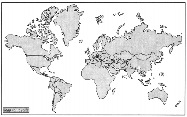
Question 30.
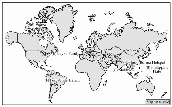
On the given political map of the World, six geographical features have been marked as A, B, C, D, E and F. Identify any five with the help of the following information and write their correct names in the map. 5
(A) Important Canal
(B) Minor Plate
(C) Island Nation
(D) Ecological Hotspot
(E) Tidal Energy
(F) Longest Trench
Answer: